
Papoose Peeping from the South
There are a whole host of ways to see Papoose Lake from the south. (Actually, it’s much more than a host, more like a shitload, but you get the point.) These fine viewing sites are provided courtesy of the Spring Mountain range, running from Mt. Charleston, just north of Las Vegas, all the way to it’s northwesterly end at Mt. Stirling. These mountains are high; Mt. Charleston is around 11,900′. That’s high enough to see across the long distances involved here. What it comes down to then is simply finding an nice spot with an elevation of 8,000′ or more, then have a look. Of course, the necessary elevation varies somewhat depending just precisely where your sight line is. What I’ll do here is mention three possible locations I’ve been to, and can vouch for. There are many others, however, so feel free to explore.
Oh yeah, before I get into the usual locations, don’t forget the airlines. Any of the flights between Las Vegas and Reno, Sacramento and other points north will give excellent views of Papoose (and usually Groom) from the east side of the plane. All of these flights tend to follow Hwy. 95 along the west edge of the NTS, at altitudes high enough to easily see what you wanna see. So, sit back, relax, and ask the attendant for a beer as you as make a complete fool out of yourself peering out the window with binoculars.
Mt. Charleston
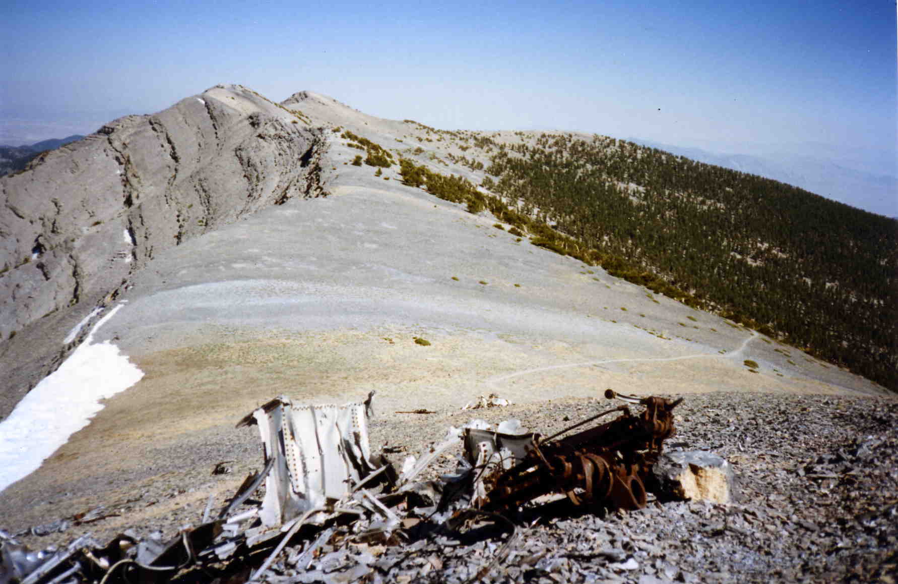
I’ll say right up front that you really don’t want to do this one! It involves a butt-busting hike of over 8 miles each way, and an elevation gain of over 4,000′. Nasty, nasty, nasty! You gotta wonder if the damn discs and aliens are worth it. Still, the view from the top of Mt. Charleston is a breathtaking 360 degree panorama, and, off in the distance is Papoose and Groom. A double treat.
A triple treat (and link to Groom) is the presence of a C-54 plane wreck right at the side of the trail, about a half mile before reaching the peak. The crash dates from November 17, 1955, when all 14 aboard were killed on their way to Groom to work on the U-2 program. The wreckage pile is quite impressive.
To reach the trail head, take Highway 95 north, about 16 miles from its intersection with I-15 in Las Vegas. Turn west on Highway 157, Kyle Canyon Road. The road climbs high into the mountains, and the community of Mt. Charleston is reached. You’ll pass a Ranger Station on the left, and it’s a good spot to get info and maps. About 19 miles from Highway 95, the road turns left and climbs up the south side of the canyon. The trail head is at an elevation of around 7,300′ and may be found hidden in the picnic area just before you come to Charleston Lodge. The trail is the South Loop trail. There is another trail that goes to Mt. Charleston called the North Loop trail. Do not mistakenly take the North Loop trail! It will also go to the peak, but is 2 miles longer. The trail head for the North Loop trail is on the opposite side of Kyle Canyon from the South Loop trail.
For anyone interested in acquiring maps of the area showing the trail, the USGS 7-1/2 minute maps are Charleston Peak and also Griffith Peak. The Toiyabe National Forest also has a map showing the trail, although in less detail than the USGS quad. It’s the “Las Vegas Ranger District” map.
But since the sight line from Mt. Charleston is 58 miles to Papoose and 70 miles to Groom, you really didn’t want to waste your energy for this one, did you?
Wheeler Pass
This is the couch potato trip. To get to Wheeler Pass, you simply drive east from Hwy 160 out of downtown Pahrump up Wheeler Pass Road, until you get to the pass (elevation 7,683′), roughly 18 miles or so. Park your vehicle, then walk about 200 yards up the spine on the south. Ta-dah!! There’s Papoose out there a mere 54 miles away (notice we’re getting closer?).
I’m not going to give specific directions, because when I did it, I didn’t bother to record mileages (Do I have to do everything for you??) Get the USFS Toiyabe National Forest map, and it will tell you pretty much what you need to know. Wheeler Pass Road east out of Pahrump. Stop when you get to the pass. Can’t miss it if you don’t make a false turn onto the many side roads coming off Wheeler Pass Road. If you can’t find it on your own, then maybe you shouldn’t be this far out in the boonies.
The route to the pass from Pahrump was fine for all but the lowest passenger cars when I did the trip. However, unless you have a 4wd and enjoy substantial 4 wheeling, don’t continue on east Wheeler Pass Road beyond the pass, down toward Hwy 95 via Cold Creek. It’s pretty gnarley.
About a 15 minute walk up the spine to the south are some fine flat ledges, suitable for plopping a sleeping bag or whatever. Be warned that this being a pass, things can get a mite windy. I speak from experience….
Mt. Stirling
This is one of my favorite spots as it also provides a nice view of the Test Site. If the day is hazy, blow it off, as you’ll be wasting your time. Also, forget about those months where there is snow up there. Access will be difficult. Not too bad on hot summer days due to the higher elevations.
Special Considerations:
You need a 4wd for this trip. The dirt road seems pretty good at first, but steadily deteriorates the further you get from the pavement. At 9.2 miles, the right wheel track becomes a major ravine, stopping all but the most crazed (i.e., stupid!) 4 wheelers. A small wheelbase Jeep C-J type vehicle might be able to get beyond this point with some road work and cut out some hiking, but it’s risky.
You’ll be looking through 46 miles of atmosphere, normally not much of a problem in the clear desert air. However if it’s a hazy day, you’ll just be wasting your time. Also, bring the best optics you can. Binoculars do only a fair job at these distances, and magnifications in the range of 15 to 30 power are more useful. If you use a higher power spotting scope, consider a tripod to cut down the shakes you will undoubtedly experience upon seeing the legendary Papoose Lake!
If you want detailed maps of the area, the most useful is probably the 7 1/2 minute USGS Mt. Stirling quadrangle. For a larger scale perspective, the 1:100,000 USGS Las Vegas and Indian Springs maps are helpful.
There is a slim chance you might encounter a lock on the access gate. In late 1994, the Nevada Highway Department upgraded many of the existing barbed wire gates along Hwy 95 to chain link gates. While this may have been a good thing, they also added shiny new locks and chains for reasons unknown.
The land on the westerly side of Hwy 95 is all BLM land (i.e., public!) up to the base of the mountains, where it becomes US National Forest. The BLM was not too happy about this, and for a time, would send out a ranger with bolt cutters if requested. Things seem to have stabilized now, and the commonly used access points remain open. The Mt. Stirling access has only been observed to have been locked once, just after the locks appeared. No one has reported any problems since, but be aware of the possibility.
If the gate is locked, for whatever reason, you have two choices. The first is to find an open access on the same side of the road within a few miles. You will note the presence of a powerline running parallel to Hwy 95 about a mile west. There is a service road under this powerline which you can access from any other dirt road coming off Hwy 95, and take the powerline road back to the main Mt. Stirling access. Your other choice is to travel, as I do, with a set of bolt cutters for those “special occasions”.
Getting There:
Mt. Stirling itself is roughly 48 miles directly northwest of Las Vegas. Access is from a dirt road that intersects Hwy 95 at milepost CL 131.1, approximately 55 miles north of I-15.
If you’re heading north from Las Vegas, you’ll reach this milepost about 11 miles after passing the Indian Springs Auxiliary Airfield. Be observant, it’s easy to miss. The median has a paved drive-across here to allow left turns onto the dirt road.
If you’re coming from the north, you’ll reach the intersection with the dirt road on the right about 8 miles after passing the Mercury turnoff and 1 mile after passing the Nye/Clark County
line.
Start up the dirt road running off to the southwest using the following as a guide (Note that they may have changed considerably over the years!):
| Mileage | Comments |
|---|---|
| 0.00 | Hwy 95, Milepost CL 131.1 |
| 0.02 | Pass through chain link gate, close it behind you. |
| 0.8 | Intersection with powerline and its service road. Continue straight. |
| 5.15 | Toiyabe National Forest boundary and sign. |
| 5.3 | 4wd trace intersects on left. Continue straight. |
| 5.9 | 4wd intersects on left. Continue straight. |
| 6.0 | Road forks at a “Prevent Forest Fires” sign. Keep right. Road gets progressively worse from here. A good place to leave passenger cars. |
| 6.85 | 4wd trace intersects on left. Continue straight. |
| 7.0 | 4wd trace intersects on right. Continue straight. |
| 7.15 | Road forks. Keep left. |
| 7.8 | Road splits, but comes back together in .1 miles. Either way, take your pick. |
| 8.0 | 4wd intersects on right. Continue straight. |
| 8.45 | 4wd intersects on right. Continue straight. |
| 8.6 | 4wd intersects on right. Continue straight. |
| 9.0 | 4wd intersects on right. Continue straight. |
| 9.2 | Road goes to hell. Parking available on right side of road. Elevation here is about 1880 meters (6166′). |
The Hike:
The object is to reach an elevation of at least 2100 meters (6888′). This is the elevation at which Papoose Lake becomes visible, generally speaking, in this neck of the woods. While there are a number of ways this can be accomplished from this location, the following seems the easiest. Feel free to improvise, however.
Continue walking up the 4wd path up the canyon, beyond where it went to hell. After about 0.4 miles there is an easy to miss 4wd path coming in from the right. Turn right onto this path and start climbing. After another 0.75 miles on this path, you’ll reach a high point, an old mining site, beyond which the 4wd path drops down and ends. Stop at this high point and have a look around.
At this location you’ve reached an elevation of about 2100 meters (6888′) and Papoose Lake is just barely visible if you know right where to look (See the viewing directions below). In reality, it helps to do a little upward scrambling to get a better view.
The simplest, although strenuous, way is to start scrambling up the spine of the ridge immediately behind (south). After a bit (Hah, a good, solid hour is more like it!) of climbing, you’ll reach a rounded summit at an elevation of 2427 meters (7960′). While this is not Mt. Stirling (it’s another 0.75 miles southeast along the crest to Mt. Stirling itself at an elevation of 2505 meters (8216′)), it will serve its purpose.
The view here is outstanding, with Pahrump visible to the southeast, the brothels of Crystal to the southwest (along with the lakes of Ash Meadows), and the Armagosa Valley to the west. A good place to hang out.
This is the first possible campsite (i.e., lots of flat spots) after leaving the high point of the 4wd path. There are a few ledges along the way part way up, where it’s possible to throw a sleeping bag and have a scenic but uncomfortable night. Nothing big and flat enough for a tent until you get near the top. A nice compromise is to set up camp at the 2100 meter spot and simply hike up the slope for 10 or 15 minutes with the optics of your choice.
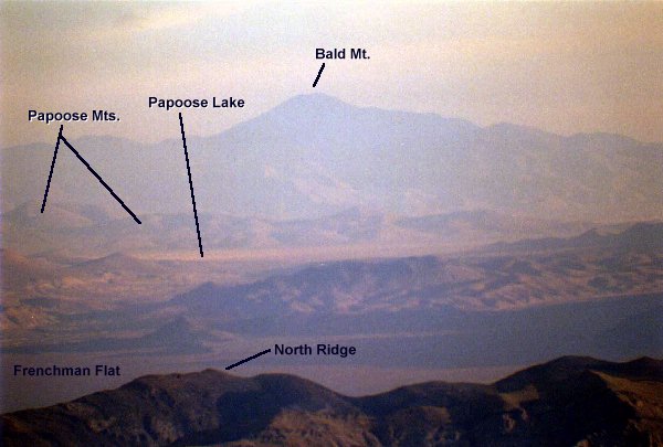
To locate Papoose Dry Lake, it helps to first find Bald Mountain. To orient yourself (What? You didn’t bring a compass??) look toward Hwy 95 and remember it runs approximately east/west here. Next look off into the distance, about due north. You should be able to see a pronounced peak that has a conical shape, but with a wide base. This is Bald Mountain. Just below Bald Mountain, the hills blocking the view of its base are the Papoose Range. Further dropping your gaze, the lake bed visible at the base of the Papoose Range is (Drum roll please…) Papoose Dry Lake. Another reference point is a small, very dark set of hills blocking part of the view of Papoose. These hills are usually pretty easy to spot.
Annotated photo of Papoose Lake from Mt. Stirling.
If there are saucer hangars built into the side of the Papoose Range, you’re looking right into where they have been claimed to be. Personally speaking, I hope you have more luck than me in seeing anything.
For more precise locating, the following is a listing of the magnetic bearings to a number of selected locations from the vicinity of the high point on the 4wd path:
| Magnetic Bearing | Distance (Miles) | Site |
|---|---|---|
| 331 | 52 | Rainier Mesa, site of many underground tunnel nuclear tests |
| 338 | 13.5 | Mercury, the “company town” of the Nevada Test Site, where most support comes from. |
| 338 | 20.5 | CP-1, the large collection of buildings located in the saddle of the ridge dividing Yucca and Frenchman Flats, is the control center for operations at NTS. |
| 341 | 34 | Yucca Dry Lake. Just beyond the lake, if the air is very clear, numerous craters from the underground tests are visible. |
| 348 | 50 | Groom Pass, where Mercury Highway crosses from the NTS to Groom Lake. |
| 351 | 23 | Frenchman Dry Lake. Site of numerous airburst tests during the testing program. This site is visible only at the higher elevations of Mt. Stirling. |
| 356 | 46 | Papoose Dry Lake. A good view right up the center of the lake to the base of the Papoose Range. This is why you’re here, eh? |
| 357 | 69 | Bald Mountain. An easily recognized landmark just north of Groom Lake, and from this viewpoint, immediately above the Papoose Range and Papoose Dry Lake. |
| 16 | 71 | Badger and Tikaboo Peaks. In spite of the distance, they are usually visible due to the clarity of the air. They’re on the east side of Tikaboo Valley, just south of the Black Mailbox. You’re lookin’ a looong way here. |
| 49 | 18 | Indian Springs Auxiliary Airfield. |
Return to Papoose Lake page