OK, this is a slightly atypical thing to post on my site, but it was too cool not to. I know there’s some who will find this really useful. Below I’ll burn some electrons to provide a context of why it’s a neat thing to me, but for those of you smarter folks who’d prefer to bypass my ramblings, just pop down to the bottom of the page for the pic. You won’t hurt my feelings.
Ahem….Let’s begin..
When I was a kid, I loved any sort of lost mine or treasure story. Practically speaking, I never had the chance to go look for anything good, but I enjoyed at least reading about the subject.
Keeping this personality defect in mind, while in college I ended up working with an older guy who told me a pretty good story. When he was young, he’d gone hiking up the East Fork of the San Gabriel River, in the San Gabriel Mountains with members of his family. One time, he related, far up the river they came upon an old cabin. He said it was in excellent condition, like the owner just left. There were still furnishings and stuff hanging on the walls. But it was definitely abandoned.
Now this definitely got my attention, even though at the time I had no idea exactly where the East Fork of the San Gabriel River was. I peppered him with questions, and due to the number of years since that hike, his memory was a bit vague. He thought it was up as far as Fish Fork, but maybe between Iron Fork and Fish Fork (I’m offering these local landmarks only for those familiar with the region….everyone else can ignore them.)
This, combined with a fascinating story of a lost mine “somewhere in the vicinity of Mount Baldy” published at the time, launched me on a multi-year exploration of the area. Several trips pushing up as far as Fish Fork, about 7 miles upstream, and finding nada, indicated this might end up being more of a challenge than I expected. A blueprint for my later life.
Keep in mind that there was no GPS system in the mid-1970s. Best you could do was a good topo map, and possibly a compass. But I got good enough with topo maps I seldom bothered with compasses. And so much more awful than that, there was no Internet. If you wanted to do research, you had to go to assorted libraries, and it was HARD. I think it involved walking through snow to get there, also.
During this exploration period I first became aware of the writings of John W. Robinson, a historian of the San Gabriel Mountains. In his book on the San Gabriel Mountains he had a section on the East Fork region I was exploring (and later he did an entire book on it), so this was just dumping gas on the fire for me.
Well, hey! My topo maps showed many of the mines Robinson mentioned, some high above the very stream I had been exploring. In particular, I locked on the Stanley-Miller Mine, which appeared to be located disturbingly high above the canyon bottom near Iron Fork, an area I knew all too well. How ’bout I just pop back up the East Fork, find some of these old trails shown on my USGS topo maps, and visit the Stanley-Miller? Thus launched what turned out to be a two year saga of misery to find the damn bastard.
My primary failing in this effort was thinking I could locate and use one of the very old trails shown on my topos to access the mine. I knew the trails might still be there as I used one on the opposite canyon wall to return from one of my Iron Fork/Fish Fork explorations, worth a minor digression.
I had become sick of all the stream crossings required for travel in the canyon bottom, so I thought I’d try an old, high trail shown on my maps that started at Iron Fork and headed downstream. Unfortunately, I quickly found the trail, and while overgrown, seemed doable, so off I went.
This all seemed pretty good to me until I reached a washed out portion of the trail, with the East Fork looming hundreds of feet below. I could see the trail continued beyond the washout, and only offering up the excuse of my youth, thought it would be just fine to work my way across it.
So I’m about halfway across, pretty much spread-eagled with a view between my legs of the East Fork far below, when it occurred to me this might not have been a wise choice. In the past, in situations where I could have done myself real damage, I really wasn’t concerned. However I was now somewhat of a newlywed, and for the first time it hit me that someone else might have some big concerns over my stupid activities. Those sort of thoughts floating around in my head certainly didn’t help with my anxiety level, but I took a deep breath and made it to the other side. (In hindsight I realize it was just the first pangs of what’s called “maturity”, but at the time it was annoying as hell. I am a very late bloomer.) Eventually I was able to descend downstream of the bridge to nowhere and kissed the ground. But because of that misadventure I knew the old trails might still exist.
I became rather fixated on hooking up with these old trails heading toward the Stanley-Miller and made a number of fruitless trips. That was how I first stumbled upon the Allison Mine, from which a trail at one time continued on to the Stanley-Miller. I really didn’t care about the Allison though….I wanted the Stanley-Miller!
Skunked at every attempt, as a last resort in 1975 I finally just decided to do the 6 mile hike up the East Fork and attempt to scale the slopes for a thousand feet or more. I’d been hesitant to try this previously as the slope looked pretty damn steep, and this newlywed-maturity bullshit was cramping my style.
In a bit of irony, the morning of that hike I ran into a ranger at the trailhead and took the opportunity to quiz him about the mine. “Oh, the Stanley-Miller? There’s nothing there anymore. That’s long gone”. Well, crap.
As an aside, the ranger did suggest an interesting alternative. He related that at one time there were plans to build some sort of power generation facility, possibly a dam, high in the canyons westerly of the Narrows, and that if you found the right spot there were still old boxes of insulators stashed. I dismissed it as the terrain was really nasty and I generally found it an uninteresting target, but in later years did come upon land records identifying several full sections identified as a “power line withdrawal”. The withdrawal was later rescinded and the land returned to the forest service. But enough of these digressions.
I charged up East Fork and reached Iron Fork with minimal effort. Sadly, I was getting good at this. I picked the most likely line up a scree slope on the east slope and just started climbing. It turned out not nearly as bad as I had expected, not that it was easy.
What did creep me out on my ascent, for a couple reasons, was the herd of about 8 bighorn sheep I rousted. They stayed about 50 feet above me for much of the climb, giving me a pretty extreme stinkeye. With them having lambs present, I was worried about these rather big suckers charging. Also, given the relative rarity of bighorn sheep at that time, to me it was always a good indicator that I was in the middle of bumfuck nowhere and subject to getting myself into deep crap should anything go wrong. Wunnerful.
But after 45 minutes of climbing, none of that mattered. I came upon a rusted can! Since junk usually heads downhill, it was the first sign in two years that I might be getting close. This was underscored as the junk started showing up more often.
I saw a few trees above me and angled in that direction. All of a sudden I crested on to a flat pad with rock walls and a chimney! Finally made it.
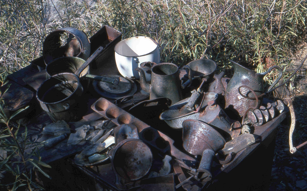
Looking around the cabin area there were just piles and piles of interesting “stuff”. Clearly a few others had been there before me as things had been placed on rock walls, perhaps for pictures. But there was plenty to be found (I suspect today, with the mine’s considerable footprint on the Internet, anything carryable is gone)..

At the Stanley-Miller Mine in 1975. Yes, I still look exactly like that. Note high tech green water bottle. I have no idea why I loved it so, it always tasted of plastic.
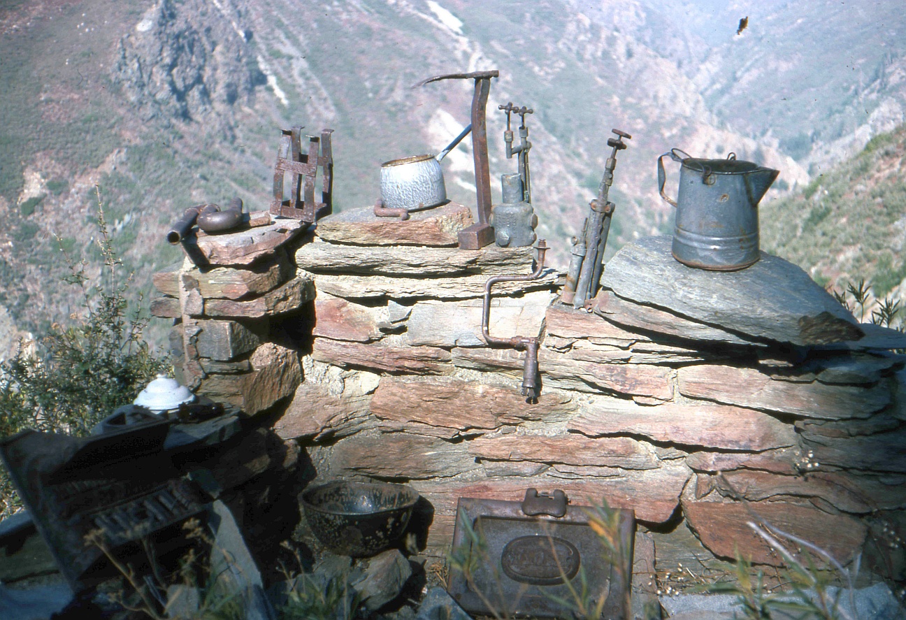
A small sample of all the stuff at the cabin. I didn’t place these there, someone earlier did.
Even more stuff on a wood burning stove. Knowing human nature, I’d bet this is all gone, except maybe the stove. Hell, maybe even that!
I probably stayed for less than 30 minutes before heading back down. I had got a late start and wanted to be back at the car by nightfall, with along hike ahead. It was also one of the remotest areas I had been into solo, at that point, and with the creepiness of the ascent I wanted the hell outta there. I’m a bit embarrassed to admit I managed to completely miss the mine and all its equipment, located several hundred feet away. It didn’t occur to me to look beyond the close proximity of the cabin. Duh!
After that, I had no burning desire to return to the Stanley-Miller, but then a couple years later a foolish friend thought it would be “fun” and we did it. We finally found the very cool mine and all the neat machinery. There was a large diameter iron pipe, running down the slope that apparently brought water to run the milling equipment. We followed it a bit, but that damn thing just kept heading up the slope out of sight. Since we were doing this as a day trip, we didn’t have the energy to spare to chase the pipe up the hill.
The pipe mystery was solved a few years later with a couple of friends. It was clear doing it as a day hike left little time or energy to explore it properly, so we decided to overnight at the bottom, near Iron Fork, and do the climb to the mine fresh in the morning. This time we did follow the pipe up, and that sucker went a full thousand feet higher! They had some serious water pressure. At the top of the pipe’s upper end, it joined a rock flume we followed a few hundred yards until it stopped at a ravine, apparently the mine’s water source. Looked in surprisingly good shape at the time. Oh, and the reason I know the height the pipe gained is that if you know just where to look, you can see it in Google Earth. Google Earth spoils so many mysteries…..
I think my last trip to the Stanley-Miller was a day trip with a friend in 1987, and that’s been it. I learn from my mistakes.
So with all that contextual nonsense out of the way, let’s return to the present, shall we?
I’ve been working on a number of projects lately requiring the use of old aerial photos, and I stumbled upon a new, unfamiliar source, the UC Santa Barbara library. I found some very useful images from 1928 for what I was interested in, and then I started to look around at their other holdings, looking up my old haunts.
Poking around up East Fork there clearly were what appeared to be structures in the vicinity of the Stanley-Miller, but they seemed to be too close horizontally to the canyon bottom. However, once I had a chance to look at the site in Google Earth, I remembered just how steep the slope was. Those were indeed the Stanley-Miller structures.
The image also shows the many trails that provided access to the mine, the object of my old, fruitless quests. Further, I could trace the “high trail” that ran to the Allison Mine. Turning to Google Earth, it was possible to see that at least some portions of this mysterious route still exist. While I admit to twitching a bit, that high trail is some serious shit and not something I’d risk today. You know…..maturity and all.
Anyway, my apologies to those of you that have waded through all this preamble. Here’s the pic of the Stanley-Miller Mine area in 1928:

Aerial photo of the East Fork of the San Gabriel River showing the Stanley-Miller Mine in 1928. Note all the old trails are visible. (Courtesy of the UC Santa Barbara Library)