(Note: A blanket prohibition by the National Park Service in late 2014 outlawed operation of “drones” or RC aircraft inside National Parks. The flights described in this writeup occurred in early 2013, well before the prohibition went into effect)
I had been doing more studying on using drones for mapping/photography purposes and I was eager to try it again after my less than satisfactory attempt at the Pejunkwa ruins. I had managed to decrease the interval rate on my Canon A2200 from 5 seconds per image to 3 seconds giving me more images per flight. BTW, one of the reasons I really like this camera (other than it’s cheap and light at 133 grams!) is that it doesn’t have image stabilization. This might seem counterintuitive, as image stabilization usually works rather well….if you’re hand holding the camera. But in many cases the vibrations present on a multirotor can totally swamp a camera’s stabilization abilities and result in blurred images. If the camera’s stabilization is turned off, or it doesn’t have it, shooting above 1,000th of a second usually results in a good image. But I digress….
One of the places I have passed many times while searching for Bill Ewasko is (are?) Samuelson’s Rocks in Joshua Tree National Park. It’s something of a landmark about two miles in from the paved road consisting of a low, rocky hill, maybe 50′ high running about 550′ north-south and about 330′ east-west. It’s primarily known for the eight inscriptions carved into the rocks around the site by a (slightly crazy) guy named Samuelson in the late 1920s, through the early 1930s. Anyway, this struck me as a good target to see what sort of aerials I could create and anything more.
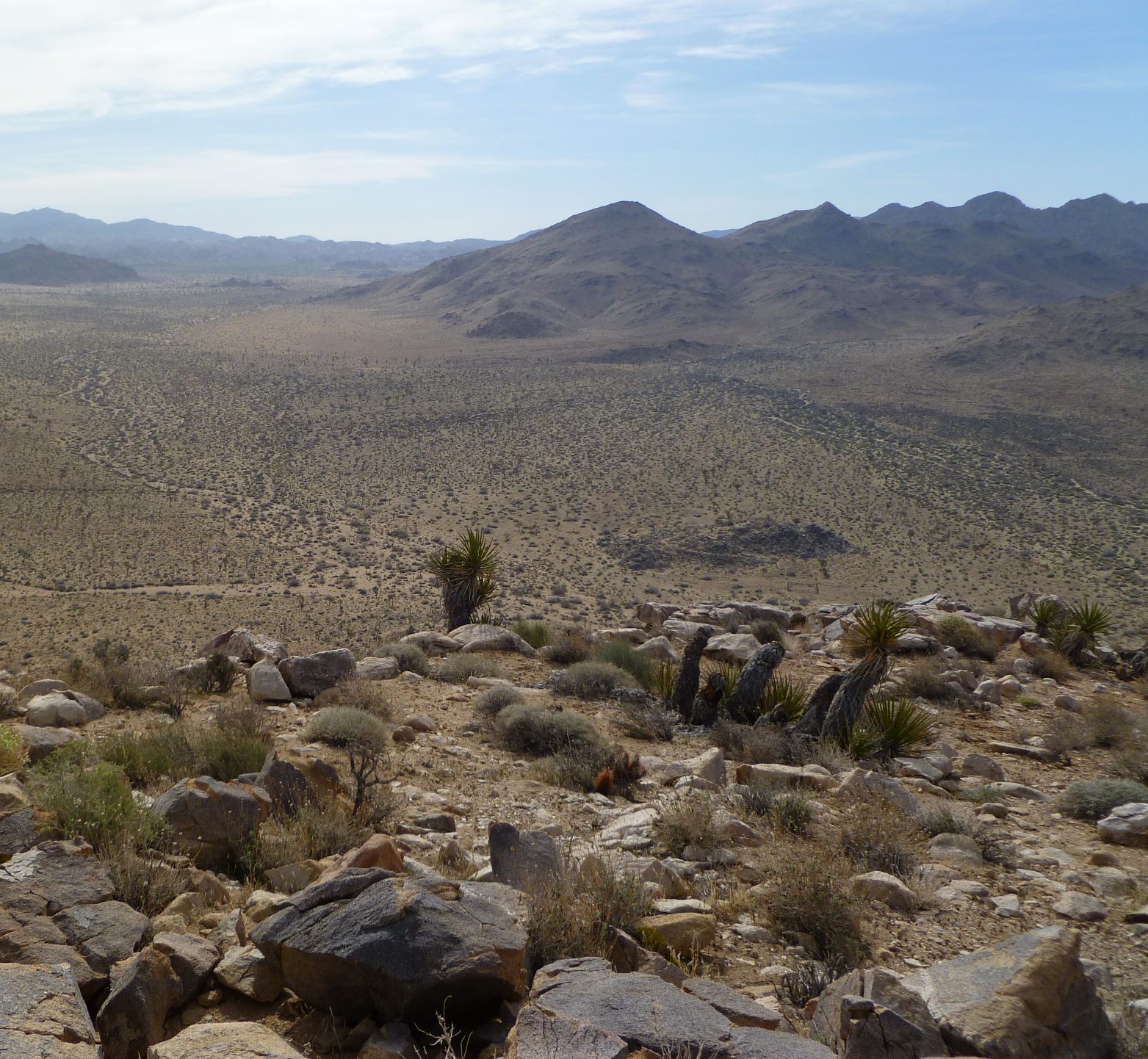
On a previous trip, looking southeasterly towards Samuelson’s Rocks from the adjacent hills. They are the rockpile in the middle of the image just right of the yucca plant.

This is a close up of Samuelson’s Rocks looking toward the southeast from some nearby hills.
So (very) early one morning found me lugging my quad the two miles in to Samuelson’s. I brought batteries for two flights in case something didn’t go quite right on one of them. From earlier experiments I determined a 250′ altitude should give me good resolution so I launched and put the flight controller on altitude hold when it reached that altitude. My flight controller, an APM 2.5, uses a very sensitive barometer to sense height and typically holds it to within a meter. There was a very light breeze but learning from past bitter experience, I choose a day when conditions were generally calm. I was able to make the two 8 minute flights without incident, obtaining 153 images on the first flight and 152 images on the second flight. I was there maybe 30 minutes max. Left nothing but footprints, took nothing but pictures.
Back home I went through the images and tossed those which were blurred or off-angle (not looking straight down). I then fed those remaining 124 images into Autopano Giga and let it do its thing. This excellent software doesn’t care how the images are rotated, it manages to find matches, slices and dices them in magical ways I don’t understand and spits out a huge panorama. What’s “huge” you ask? Well, it ended up as a 600 meg jpg file. In my world, that’s huge. Looked pretty damn good, too.
Here’s a version I cropped and resampled down to 2.9 megs. It lost some resolution in the further compression but you get the idea. North is at the top and there’s the remains of an old corral plainly visible on the left.
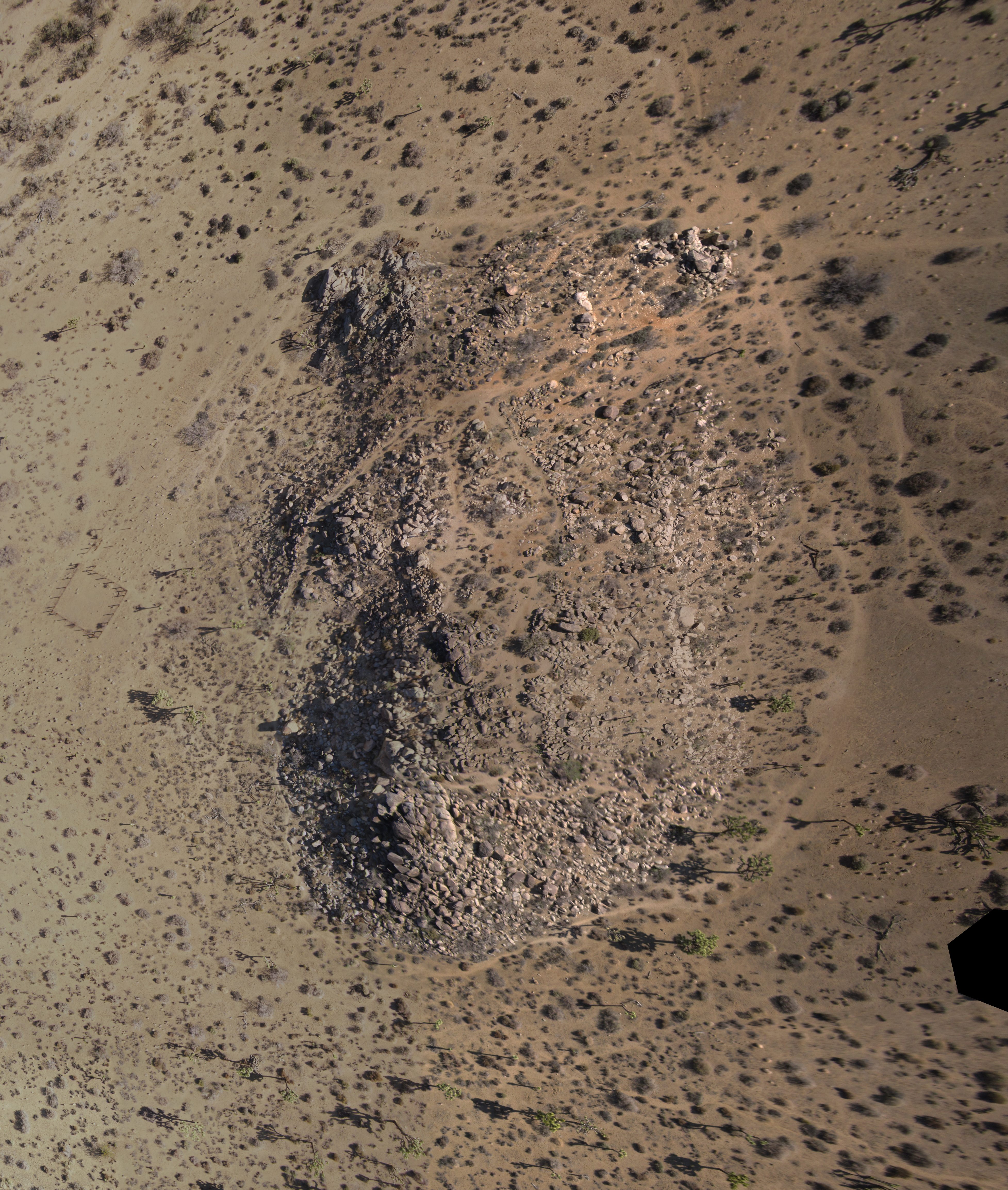
This is a cropped composite of 124 individual images. North is at the top.
So just how good is the resolution in the original? Well, since you asked (you didn’t but I’m telling you anyway), here’s an example. There is a rusty old bedframe up in Samuelson’s Rocks, presumably Mr. Samuelson’s. It tends to get moved around by hikers but it’s always up there somewhere (There’s a picture of it at the bottom of this webpage). If you’ll look at the partial image below I circled the location of the bedframe the day I took the images. If you go back to the big image and look in that same spot you’ll see the bedframe. But I also went through the original full-resolution single images and found one that happened to be centered on the bedframe, which I’ve cropped out and also added below. The maximum width of the bedframe frame is only about 1 1/2 inches. Yet this dimension is plainly visibly. That’s pretty neat!

The location of the mentioned bedframe is in the center of the red circle.

This is a crop of one of the original 14 megapixel images showing the bedframe at full resolution. The members are about 1 1/2 inches wide.
Had I stopped there I would have been very satisfied. I am well on my way to developing the ability to create high resolution aerial photos of whatever I like. But then in my readings I came across something called “Structure From Motion” (SFM). This is a technique, only a few years old, which can create a 3D model of an object from a series of individual photographs taken by a camera with known settings. In essence, it uses serious computer horsepower to look at craploads of images, finds common markers in the images, and looks at how these markers change with respect to each other as the camera viewpoint changes and creates a 3D model from this. It turns a camera into a poor man’s laser scanner. I don’t pretend to understand how it works, but I suspect it was reverse engineered from alien Roswell technology.
A few things make this a fantastically attractive proposition. The first is there’s free open source software to do this, VisualSFM. The second is that it doesn’t require high precision (expensive) photogrammetric cameras. Cheap point and shoots like my Canon A2200 will work quite fine. And finally, while it was originally conceived to make 3D representations of objects, it will also work well when used on terrain features. This.Could.Be.Interesting!
So I selected the 124 Samuelson images and dumped them into VisualSFM without really knowing what I was doing (Read the manual??! Why??). About 30 minutes of computer chomping later, out pops a pretty cool 3D surface. Now just doing a screen grab of the surface really wouldn’t give a good representation of its scrumptious 3Dness, so below is a short video clip of the Samuelson’s Rocks model being rotated around. I think the holes in the surface are due to areas of shadow. I deliberately took early morning shots when the Sun was low to enhance features and bring out the terrain in the images. Turns out this is not what you want when doing a SFM model. High Noon with full lighting is better. Go figure.
So considering this was done with a cheapo Canon with no ground control whatsoever, I think it’s a pretty impressive result. If I add the known scaling of a few points in the model I can then create a scaled 3D model and wrap the aerial photo over the surface. But I’m still figuring that out.