Despite all my trips to Joshua Tree, I had never got around to visiting Cary’s Castle, an obscure site in the southeast part of the park. Since this wasn’t another trip hunting for Bill Ewasko, I was able to talk Patrick McCurdy and Pete Carlson along. They enjoy dumb hikes, but even they have their limits (I think…I’m not certain). Patrick had been to the Castle once before, but Pete and I hadn’t. (Here’s Patrick’s Rashomon version of the adventure. You should believe me though)
Cary’s Castle is a somewhat sensitive spot receiving increasing visitation. The Park Service tries to keep it low profile in an effort to keep out the idiots. As far as I know, they won’t tell you where it is. Your tax dollars at work. There is no trail, just a route up a series of washes and a bit of rock scrambling. Some hikers place cairns to mark the way and other hikers knock them down. So it goes. If you don’t know which fork of the various washes to take, it’s easy to get lost or otherwise messed up. It was amusing to see the footprints in the sand from previous hikers headed up the wrong forks. The topography is such that if you don’t know the right route you WILL take the wrong turn.
Although some would like to consider the location of Cary’s Castle “secret”, Cary’s Mine shown on USGS topo maps and various mapping software products such as Garmin’s. And there are Googleable (if that’s a word) GPS tracks to the place on the Internet. It is easy to find the location. Because of this I haven’t bothered to cloak our route to and from the Castle in this writeup.
Beyond a visit to the Castle, there were some…..other things we wanted to look for in the general area. Just what those things were, well….you don’t need to know. But if there’s weird shit to be found in the desert, well we’re on it.
So just who was this Cary guy?
When you read what sparse documentation has been written up on Cary’s Castle it usually starts along the lines of, “While little is known of the “Cary” behind Cary’s Castle, blah, blah, blah”. This is just, well…..lazy. There is a LOT of information available, one just has to look for it. Sometimes it’s not on the Innerwebs, but might require an actual visit to a government office and dealing with government employees (you know, old school research). What follows is a compilation I prepared from a variety of sources, including Federal census records, Riverside County records, a brief visit to Ancestry.com, and even the good ol’ Mormons and their familysearch.org website.
Arthur Loyd Cary was born in Bogue, Kansas on July 18, 1914 to a farming family. By the time he was five, he and his family had moved to Colorado, a bit west of Lamar, eventually settling in Granada, Colorado. There he went to high school and met his future wife Eleanor Fern Grisham (also spelled Grishom and Gresham).
By 1935 Cary had moved to the Coachella Valley in California, residing in El Centro, and by 1940 he was living just north of Holtville, still in the Coachella Valley. During this period he and his wife had a son, Harold D. Cary, born November 5, 1939.
The Federal census records for 1940 show Cary, his wife Eleanor and son living with his father and mother in-law, Tom and Ollie Grisham. Cary was employed as a vegetable truck driver making $1,820 annually (about $30,000 in 2012 dollars). Tom Grisham was employed as a ranch foreman but as we’ll soon see, it appears the whole Cary/Grisham clan had an interest in mining.
Voter registration records indicate Cary lived in Holtville for many years, at least until the 1960s, working as a mechanic and tractor operator. Oh, and he and his wife were Democrats for those who keep track of such things. Eventually he relocated to Nevada, near Las Vegas, and died April 8, 1976 in Henderson.
And what was he doing out there?
Cary was involved in the filing of four claims at the end of the 1930s decade, easterly of Eagle Peak. They were “Beacon #7”, “Beacon #8” and “Welcome Stranger”, all in 1938, and “Duffie No. 1” in 1940. In some cases the filings were jointly done with his father in law and other members of the Grisham family. Apparently small scale mining was an interest of the Grishams. Also note that Cary wasn’t the old grizzled desert prospector we normally would think of, he was only about 24 or 25 years old.
The Beacon #7 claim was located on February 21, 1938. In addition to Arthur Cary the other locator was listed as “Allie” Grisham (probably Ollie Grisham, his mother in law, there are lots of typos in old Recorder records). Witnesses were listed as Fern Grisham and Sam Grisham. This was a lode mining claim, about 600′ x 1,500′, generally running east/west, located in the SW 1/4 of the SE 1/4 of Section 34, T5S, R12E.
The Beacon #8 claim was also located on February 21, 1938, with the same locators and witnesses listed. The description suggests it’s adjacent or very near the Beacon #7 claim.
The Welcome Stranger Claim, which today is generally called “Cary’s mine” was located on November 12, 1938. In this instance Cary was the sole locator. Since the location wasn’t within a surveyed portion of the Township/Range system, Cary estimated the location of his claim to be “…about 4 3/4 miles in an E/S direction from….summit of Eagle Mountain”. Apparently Cary wasn’t too great estimating distances over rough terrain and USGS topo maps for the area wouldn’t arrive for a few more years. As a result he overestimated the distance by about 1 3/4 miles.
The final claim Cary was involved in, Duffie No. 1, was located January 24, 1940. This was an interesting record for the number of names listed as locators. There was Mr. & Mrs. Burke Duff, 31%, Mr. & Mrs. Tom Grisham, 30%, Mr. & Mrs. A. Cary, 29% and Mr. Buster Beach, 10%. Other names listed as locators, but no percentage given, included Miss Betty M. Duff, Mrs. Wilson Duff and “Jr. D. Cary”. I believe the last name refers to Cary’s son Harold. Not too shabby for a two month old kid! The location given was Section 23, apx., T5N, R12E. Given that there’s a “Duffie No. 2” mine located at the toe of the Eagle Mountain range, just under 3 miles northerly of Chiriaco Summit, I believe the Duffie No. 1 claim is in that vicinity and not up where Cary’s Castle is.
And we now return you to our hike already in progress…
We reached the trailhead and started up the canyons about 8:20 AM. We made good time and managed the 4 miles to the Castle in less than two hours. Since we had Patrick’s previous GPS track, finding the various sites in the Castle vicinity was easy.

The obligatory shot of the doorway into Cary’s Castle.
The Castle was still in pretty good shape and lacking and significant vandalism. Inside the Castle, on the rock ceiling were some reddish petroglyphs. There apparently was Indian usage of this area in the past, as not far away I found a chunk of quartz that looked like it had been flaked into a sharpened tool that fit comfortably into the palm of my hand. It looked like it was some sort of chopping device. After a quick visit to the mine shaft, we started our exploring of the area.

Some of what was left inside of the Castle.

Looking out from the inside of Cary’s Castle. The register is in the ammo box on the shelf.

A couple of the pictographs on the rock ceiling inside Cary’s Castle.
In our wanderings near the Castle we came upon what we called “Cary’s Dam”. This was something unexpected having never heard of the existence of such a feature in anything I’ve ever read about Cary’s. It was a low concrete structure, perhaps eight feet across a narrow point of one of the many rocky ravines that cover the landscape up there. It looked like the builder tried to stretch the use of concrete by using 55 gallon drums as filler material for the dam. Although the area behind the damn was all silted up, at one time it would have held back easily thousands of gallons of water after a rain in the solid rock ravine.

Patrick standing on top of Cary’s Dam. Although now silted in, at one time it would have trapped thousands of gallons of water after a rain.
One of the more stupid members of our little group had the bright idea to take an “alternate” route back down out of the Cary’s Castle area. It didn’t look that bad on Google Earth and it was only about 1.6 miles….How hard could it be? We found out.
What looked like a reasonable route on Google Earth and topo maps turned out to be a rocky, Acacia choked nightmare of a canyon. When we weren’t carefully climbing down rock slopes we were getting torn at by thorny Acacia shrubs in the canyon bottom. It took us a full hour to make it only one mile….all downhill. To give it perspective, Pete thought it was “fun”. When Pete thinks something is fun, the rest of us usually run the other way. But in this case we couldn’t, we were stuck in the damn canyon.

Me and Pete studying our alternate return route. Looks easy, doesn’t it? Hah! It took an hour to descend the next mile.

Pete and I descending the alternate return route. When there weren’t rock faces to descend there was flesh tearing Acacia bushes. Kids don’t try this at home.
Eventually we reached the relatively flat wash that constitutes the normal route to Cary’s a relaxed a bit. We were then able to pretty much triple our speed and were back out at the trailhead by 4 PM. We covered between 12 and 13 miles on this trip. Someone paying attention might observe that a round trip to Cary’s is only about 8 miles. And they would be right…..

Our GPS tracks for Cary’s Castle. The left part of the lop is the standard route. The right part of the loop is our ill-advised alternate route back down.
But is the Welcome Stranger claim really Cary’s Mine?
In a word, yes. The exhibit below shows a map I prepared from the metes and bounds legal description contained in Cary’s filed claim. The three gray circles at each end of the claim (six total) are rock cairns placed to locate the boundaries of the claim and referenced in the claim document. On a subsequent trip to Cary’s we were able to locate all six of these cairns within a few feet of where they were supposed to be when viewed in Google Earth. What was odd was that the discovery shaft, which is the anchor point upon which the claim is laid out, seemed off by about 190′. By that I mean the existing shaft was about 640′ from the north-center cairn instead of the 450′ Cary listed in his claim document. But it was still in the center line of the claim. However in our explorations we came upon a small tailings pile at the 450′ point. We initially thought it was just more dumping from the existing shaft, but then realized it may have been the remains of a small discovery shaft, upon which the claim was based. So the evidence overwhelmingly suggests Cary’s Mine is really the Welcome Stranger Mine.
The recorded claim date of November 12, 1938 provides a way to determine the age of the operation. This date is further supported by online images of a California license plate with a year of 1938 on it, found in the Castle. It’s unlikely the mine operated past late 1940 or early 1941 for two reasons. First, there is no record that Cary filed any of the annual “proof of labor” documentation required to keep his claim active. These are statements, filed with the County Recorder, that the claimant has performed at least $100 worth of labor or improvements on the claim within the previous year. Since this was never done, the claim would have become invalid by around the start of 1940. Secondly, the beginning of World War II shut down all non-essential mining operations in 1942 (Order L-208).
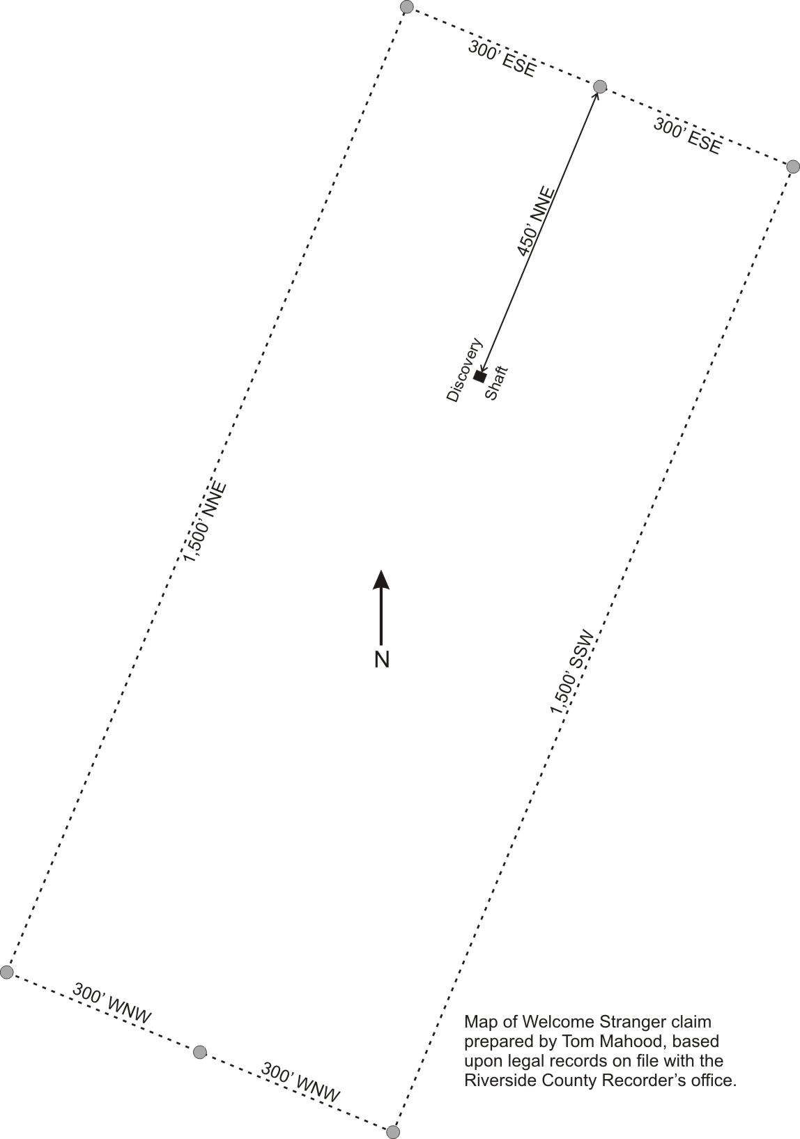
The “Welcome Stranger” claim, filed by Arthur L. Cary, located on November 12, 1938. Today, this is known as “Cary’s Mine, located a short distance to the west of Cary’s Castle.