Ummmm, what, why and how???
I choose to blame Patrick again. While he was poking around for information on the Captain Jenks Mine for that hike we did, he came upon a document titled, “Historic Resource Study, a History of Land Use in Joshua Tree National Monument“, September, 1983 by Linda Greene. It contained all sorts of interesting background data concerning early mining activities in the park. And there was brief mention of something called the “Ruby Lee Mine”. Huh?
Now some may be familiar with the Ruby Lee Mill Site, and it’s a popular hike in the southeast portion of the park. And while the mill site was associated with the mine, the mine was nowhere near the mill site, it was much further west. But where?
Greene didn’t have a lot to say on the subject of the Ruby Lee mine. This is the extent:
Well, that sounded interesting, especially the unvisited part. A quick Internet search failed to turn up anything else regarding the site, and especially no trip reports. This was quickly getting much more appealing.
But where exactly was this sucker? Greene’s description put it in the center of Section 2, a Section being a full square mile. That’s a lot of territory to begin with, compounded by the fact she hadn’t actually visited the site. So it was off to Google Earth, the friend of every adventurer.
Sure enough, GE showed what looked like an old road scar heading north into that general area out of Porcupine Wash. It was almost impossible to see and tracing it required using the time slider to view older aerials as well as peering at things in perspective view with my eyes slightly crossed. I find that helps a lot. As does wishful thinking.
So, it appeared something might be there. Time to ramp up the research. Most of this was done at the Riverside County Recorder’s office looking through old mining claim records. But I also ended up getting some history of the players involved from Ancestry.com, enough so that I created a separate page for the history of the Ruby Lee Mine, as well as Ruby Lee herself. She was an unusual woman to say the least.
The February, 1936 claim documents filed for the Ruby Lee failed to narrow things down much. They only specified the Section number (although Greene reported it located in the center of the Section). But it turned out there was another claim filed in that Section, the Broken Hill claim, made by Charles Landford and Chester Pinkham. It was filed a year before the Ruby Lee, in January of 1935.
I drew up the two claims and they were very similar, aligned North-South. Miners laid out their claims so that they follow where the ore vein is estimated to run. Going back to GE, I saw that the center of Section 2 matched very nicely with a prominent North/South ridge spine. About 1,400 feet to the east there was another North/South spine, which is where the possible road scar seemed to end. On this basis I figured the Ruby Lee claim was on the west, in the center of Section 2, and the Broken Hill claim was on the east, with the road.

The layout of filed corner markers for the two Section 2 claims. The dots are supposed to be rock cairns locatable in the field.
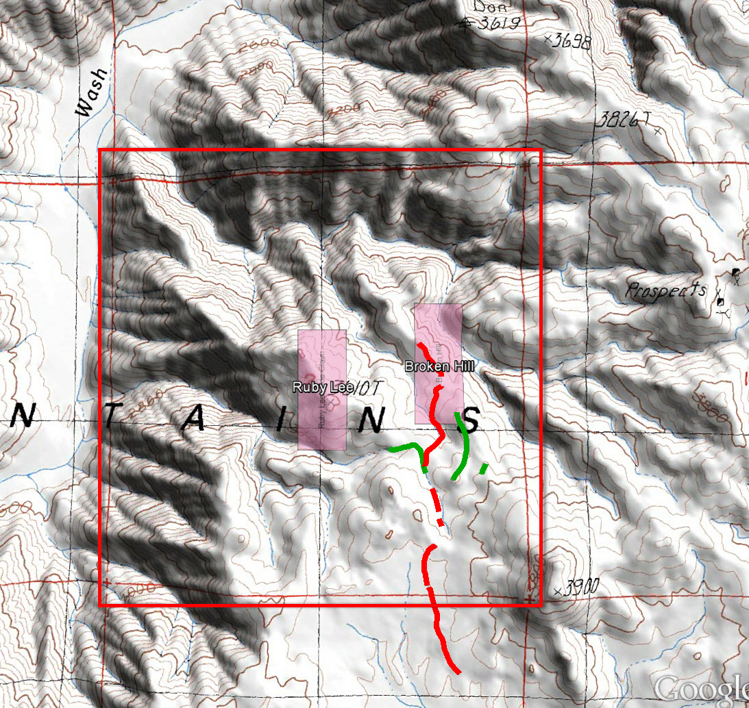
My original assessment of the claim layout in Section 2. The boundaries of Section 2 are the red square, the red lines are probable road segments and the green lines possible road segments. The prospects on the far right side are the Jenks Mine.
So, how to get there and check it out? This was one crazy-ass, remote place. There was no obvious good way to get to it, only less bad ways. The idea of making it an overnight hike was kicked around, perhaps via the original Porcupine Wash access route. However at this point in my life I only sleep on the ground if there’s a really good reason to do so. A “good reason” being a crashed alien spacecraft or better. I wasn’t satisfied this couldn’t be done as a day hike. I’m dumb like that.
On our earlier exploration of the Captain Jenks Mine, Patrick and I had used a “non-traditional” approach (“non-traditional” being a euphemism for stupid and ugly), coming off the main park road and heading southwest into the mountains via a wash. While at the Jenks Mine we had looked down to the northwest and observed the massive Washington Wash, which passed by the Ruby Lee area. But it was a loooong way down and the Ruby Lee was around the same elevation as the Jenks Mine area. That could be a nasty climb coming up from that wash.
So after considerable planning, I was able to come up with route leaving the paved Park Road, traveling southwesterly up Washington Wash, then climbing up a spine to the Ruby Lee area. The “spine climb” turned out to be only 1,200′ up, which wasn’t as bad as many more stupid things we’ve done. And the total planned initial distance was about 12 miles, suitable for a long day trip. This being the lower part of JTNP, if done during a cool time of year, say early March, it could be a perfectly agreeable hike. That was the plan anyway. These things always sound so reasonable when described to me by the voices in my head.
So we set the date for March 6. At the last minute Patrick had some schedule issues and couldn’t make it (or perhaps he was having Jenks Mine trip flashbacks) but Pete Carlson was more than happy to do stupid things. Which is why at 8 AM on March 6, Pete and I were standing at some seemingly random spot on the road in Joshua Tree, looking off to a mountain range a couple of miles away and going, “Huh?”
Remember the “cool time of year” aspect? The forecast was for 81 degrees at the truck, pretty damn warm for early March, but doable (In fact it was hotter, up to 86 degrees when we finally got back). Pete had 4 liters of water and I had 4 3/4 liters and off we went.

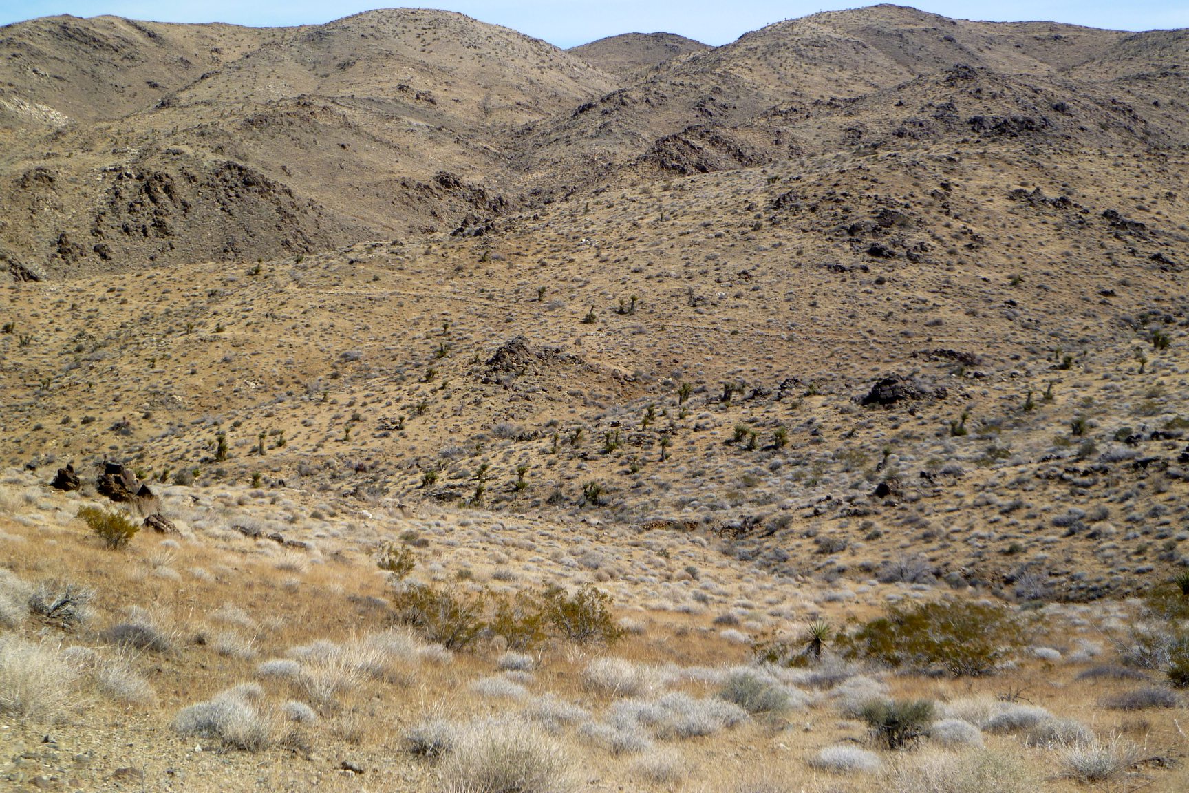
So it begins…..About to head off to the low point in the distance. The start of those hills is two miles away.
We were just sort of following the drainages up onto the alluvial fan formed by Washington Wash, knowing it would bring us into the canyon. So how were we able to find the one little washlet that went into a side canyon, parallel to Washington? I don’t know, but we did, but after only a little confusion we climbed over into Washington Wash where we should have been.
Travelling up Washington was a dream. There had been a little bit of rain a week earlier and it left the sandy bottom hard packed. We kept referring to it as the sidewalk. In only two hours we had reached the base of our ascent route.

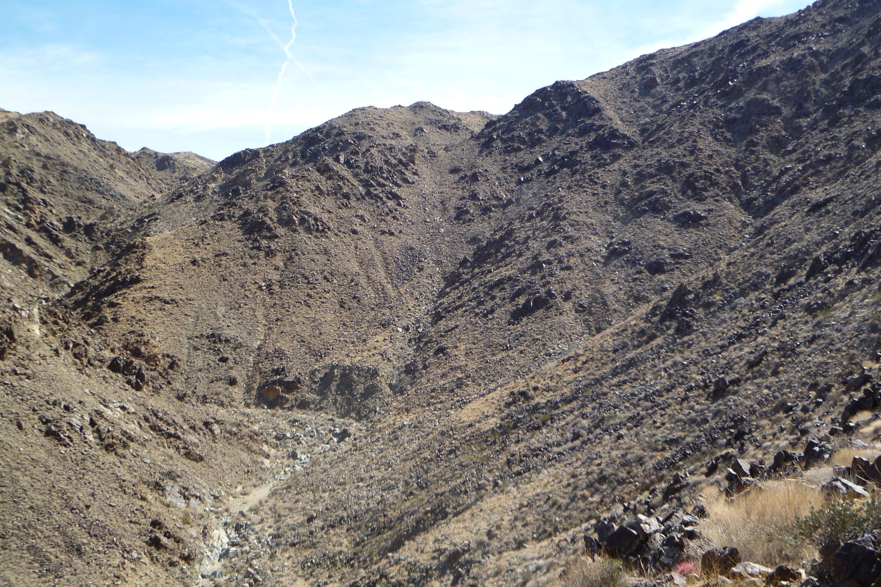
Our ascent route is up the spine towards the upper left part of the picture.
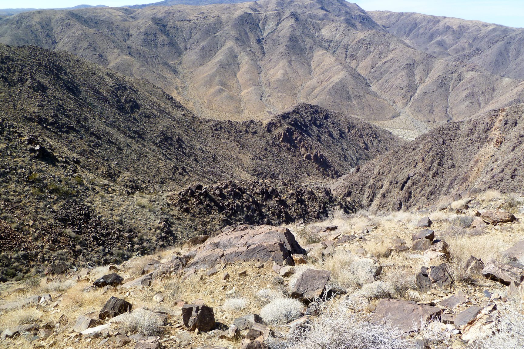
The climb really wasn’t that bad. Steep, but good, solid footing. On the way up we were able to look across a canyon and eyeball our proposed descent route. To maximize our coverage of the Ruby Lee area, I had us going up one spine (where I guessed the Ruby Lee claim to be) and back down via the spine with the road scar (where I thought the Broken Hill claim was). The descent off that spine looked possible, if not wunnerful, but not something I’d want to go up. And in an hour, we were on the top of the route we had chosen.
Our descent route, as viewed from our climb up. The descent is down that debris field in the center of the picture, ending at the bend in the wash. How bad could it be?
The view, looking up from Washington Wash, was of very rough and jumbled terrain. But once on top it was relatively flat and rolling. Moving along the top of the spine, we quickly noticed the old road scar on the spine to our east. That was our exit route. At the high point of our ascent spine, we came upon a rock cairn. As this was in the center of where I had plotted the location of the Ruby Lee claim, I guessed it to be the discovery monument (which in hindsight I was probably wrong about). We looked around for other corner markers but didn’t see anything.
Looking easterly towards the road scar.
We eventually joined up with the old road and had a close look at it. It was very hard to see, and often I had to refer to the segments I plotted on my GPS to follow it. Other times it was more visible, with rocks lining its edges. We followed it a bit southbound toward Porcupine Wash but eventually had to stop as it was going in the wrong direction from where we needed to go. More adventuring to be had!
Turning back north, we traced the old road on its way to the other spine. When doing my GE searching I had noticed some things that were possibly road scars but wasn’t sure. On our way back we had a look at these and they turned out to be natural features. Nothing interesting.
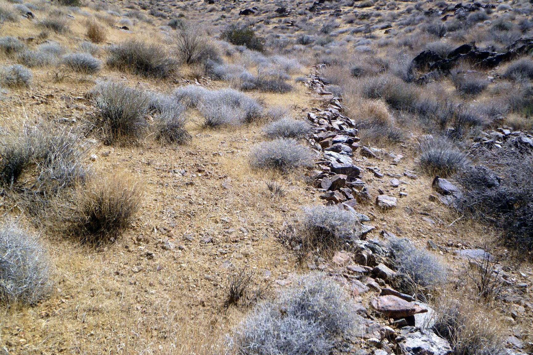
One of the more defined road segments.
Heading out on to the spine, the road eventually came to an end. Just below that point was a small open cut or prospect tunnel, clearly mining workings. Next to it was a decent sized cairn which sort of looked like a discovery monument. But searching around the area failed to turn up any trash or other human debris. In fact, other than the road scar and a few cairn, we saw no evidence of human presence at all. No rusted cans, wood, broken glass or pieces of wire. This seemed somewhat odd for a site supposedly worked from the 1930s up to at least the 1950s.

A prospect at the Ruby Lee site. That cairn of rocks just above it may be the discovery monument for the claim.
Continuing beyond the prospect, we came upon a couple more cairns and noted their locations for later study. Then came time to descend.
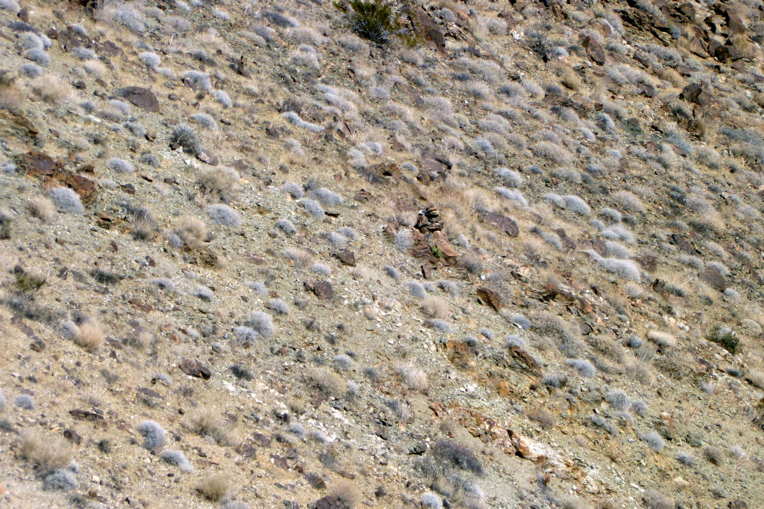
A typical corner marker photographed with zoom. If wasn’t worth climbing down for a closer look.
The first part was a small descent of several hundred feet to a small saddle, which was sort of a pain. I had brought only one hiking pole and I’d consider it a two pole descent. Pete, OTOH, didn’t bring any poles and had only trail shoes on. This was quite a handicap for him, to the point where I could almost keep up with him. But not quite.
Looking down, about to start our descent. First stop is that vague, small saddle in the left foreground. Then over the edge into the abyss.
The second big drop was sketchy due to the looseness of the terrain. We were both getting rubbery legs. In my case I suspect I also wasn’t quite hydrated enough as I finished my first 3 liters on this descent and it was getting warmer dropping into the canyon. We thought that getting to the canyon’s bottom would leave us home free, but it was a bit jumbled until we broke out onto the wonderful flat, openness of Washington Wash. We crashed here a while to rest and I downed another full liter of water, over-hydrating a bit and adhering to the “better in me than on me” philosophy. That left me 3/4 liter for the 5 mile trip out. It didn’t seem like a lot but it was all downhill on a good surface. We finally reached the truck, around 4 PM, having covered 14.0 miles. We were pretty beat.
A few things in hindsight (which is just another way of looking out of your ass)….
I think I initially had the two claim locations transposed. I put too much weight on Greene’s description of the Ruby Lee being in the center of Section 2. After analyzing what we observed, and plotting out the few corner markers we came across, I now believe the scar we saw on the second spine was that of the Ruby Lee claim and the cairn its discovery monument. This is also consistent with it being a worked site. The cairn we came to on our ascent route was most likely for the Broken Hill claim which has no record of it ever being worked. Based upon this, here’s the way I think the claims actually lay out in Section 2.

After visiting the area, what I believe the claim layout to be. The blue line is our GPS tracks.
Also, I don’t think this is really a “hard” hike. The distance and climb is very similar to an ascent of Quail Mountain from the Juniper Flats trailhead. Of course the Quail Mountain hike has a defined trail for much of the approach, which makes for easy, mindless walking. And a trip to the Ruby Lee does require good route finding skills as it’s all wilderness. This is further complicated by its lower elevation location, limiting access to essentially the cooler months of the year.
I think what made this trip harder for us was the descent route we used (I use the word “we” even though I picked it….Pete’s stupid to listen to me anyway). It made sense on paper not to backtrack to the route we used to ascend into the area. But again, with that looking out of my ass view, the descent would have been so much easier via that route it would have been worth the backtrack.
Beyond saying that, I can’t recommend it as a hike. First, you really have to know your stuff to be travelling around such a remote area. Do something stupid and you could die. And secondly there’s nothing to see there. That was the real surprise and disappointment to me. There are many very interesting mining sites in JTNP. Unfortunately, this isn’t one of them.
But hey, that itch was scratched.
Oh….yeah…..just one more thing. Now that you’ve read the book, see the movie. I did up a modest video of the hike below. Notice what a bastard I am, making you read all those stinkin’ words before I tell you can just sit on your fat ass and watch a video instead? I’m sneaky that way.