Well, one of them anyway.
Anyone who does Googling around for aircraft wreck sites eventually comes across purported databases of crash sites. And anyone who has ever actually been out looking for these listed sites knows to take such database info with a substantial portions of salt (I heard salt is no longer bad for you too!)
If wreck site locations are in these databases (often broken up by states) they are at best only given to the nearest minute of latitude and longitude in location, so not too precise. And there’s really no indication of the quality of the data, or even where it originally came from. Newer civilian crash sites can often be looked up in NTSB databases, but older ones are much less available there.
So it was with a jaundiced eye that I came across a listing in the southern part of Joshua Tree National Park for an aircraft wreck that occurred February 4, 1983. It was a two engine Beechcraft, N1586W, which crashed killing both occupants. The coordinates given, 33 54N, 116 09W, put it in a remote southern part of the park. Hmmmmm….This could be interesting. But there’s no way I’m headed off chasing geese or Beechcrafts based solely upon this database.
So hopping over to the NTSB, I found a little bit more. Not the usual lengthy report, but a few paragraphs of info, which seemed a bit skimpy for an incident where two people died. Here’s the bulk of the info (the NTSB report contained no coordinates or other locating data):
THE PLT & PASSENGER HAD FLOWN FROM BERMUDA DUNES TO YUCCA VALLEY, CA ON A BUSINESS FLT. REPORTEDLY, THEY TERMINATED THEIR BUSINESS EARLY BECAUSE WX WAS BUILDING OVER THE MOUNTAINS BETWEEN YUCCA VALLEY & BERMUDA DUNES. WHILE ON THE RETURN TRIP, THE PLT REPORTED THAT HE HAD PROCEEDED TO A POINT WHERE HE HAD BERUMDA DUNES IN SIGHT, BUT ELECTED TO DIVERT BACK TO THE HIGH DESERT ARPT (NEAR YUCCA VALLEY) TO OBTAIN FUEL. AT APRX 1420 PST, THE PLT & PASSENGER TOOK OFF AGAIN FOR BERMUDA DUNES.
SUBSEQUENTLY, THE ACFT IMPACTED RESING TERRAIN NEAR THE TOP OF A MOUNTAIN RIDGE ALONG THE EXPECTED ROUTE. SEVERAL SOURCES REPORTED THAT THE WX HAD DETERIORATED IN THE VICINITY OF THE CRASH SITE. THE OWNER OF THE HIGH DESERT ARPT STATED THAT WHEN THE ACFT DEPARTED AFTER REFUELING, THE WX TOWARDS PALM SPRINGS WAS IFR. THE OWNER OF A HELICOPTER AG OPERATION NEAR DESERT HOT SPRINGS, STATED THAT THE WX BUILD-UP OVER THE MOUNTAINS WAS NOT CONDUCIVE TO VFR FLT OPERATIONS.
Looking at the coordinates in Google Earth showed the listed impact site to be on a ridge above a feature listed on topo maps as “The Blue Cut”. I had seen this before and wondered about it. A little more research showed it was named for a distinctive blue coloration on one side of the canyon, caused by the existence of a significant fault. Aside from this location being of interest to geology dweebs, there really wasn’t an attraction there. No mining that I could find, not even any old roads. But I was a little curious to see it for myself.
I studied the terrain knowing that the pilot was attempting to get from Yucca Valley to his home field of Bermuda Dunes while trying to avoid cloud buildups. The Blue Cut made a lot of sense (if you are into what they call “scud running”). The crest of the Blue Cut forms sort of a pass between Joshua Tree NP and the lower desert to the south. Someone familiar with the area’s terrain might be tempted to use it as a sneaky way to get in under the weather. And the accident report’s description of impacting into rising terrain near the top of a mountain ridge was certainly consistent with this terrain. So…..Time for a hike!
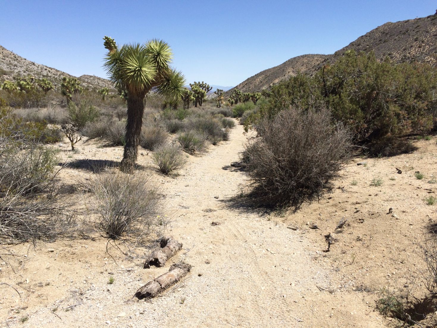
It looked like a cross country jaunt off of Geology Tour Road in Pleasant Valley would be a fairly easy access to the area. So much so that I was able to talk Jeri into coming along. She usually displays enough wisdom to avoid such trips with me, but I must have been especially convincing that it was easy. It helps that I truly believe this nonsense when I spout it. I also may have said something about “wildflowers”. Don’t remember. So early one morning, there we were in Pleasant Valley, staring off to the southwest at the Blue Cut.

Looking at the Blue Cut from the start of the hike in Pleasant Valley. It’s the low point in the mountain range in the center of the image.
It actually was a pretty easy hike. We just followed the drainage wash that flowed out of the Blue Cut. The wash surface was nicely packed down, almost to that of a sidewalk.
As we got closer to the Blue Cut we were surprised to see a couple of sets of dirt bike tires in the sand, no more than a few days old. This marked the passing of what I take to be local assholes on dirtbikes, who came up from outside the park, through the Blue Cut, then back down to the south via Berdoo Canyon. A pretty serious violation but since everybody wants nice parks but they don’t want to pay for them, we can’t afford to have rangers doing back country patrols. It was pretty annoying to have to look at the tracks for much of our route.
Anyway, that grumbling aside we eventually entered the Blue Cut and it was rather nice. It was easy to see how the fault split the canyon and produced two different colors on each side.
At the saddle of the Blue Cut, looking back toward Pleasant Valley. Pretty mellow terrain.
As we neared the saddle of the Blue Cut it was time to climb the ridge spine to the south. This was the point Jeri started to see the error of her decision, so I stayed out of reach, saying encouraging things. Reaching the top of the ridge, everything was again wunnerful (i.e., pretty much flat), and we started westerly toward the coordinate location. Great views of the low desert, Indio and the Salton Sea.

The view of the low desert from the ridgeline. That’s Indio and Bermuda Dunes just to the left of center. Mount San Jacinto is visible at the far right. Excellent View!
As we neared the coordinates Jeri thought it would be as good a place as any for her to flake out and admire the view so she sent me on to frolic along the ridge unhindered (in her defense, I was wearing boots and she had on only trail shoes, and this ridge was challenging terrain).

Jeri on the ridge, thinking it would be a great idea to get off this damn thing. Note pointy thing in her right hand, which is why I’m taking the picture from a distance.
I ended up doing a loop around the listed coordinates, scanning the area visually and with binoculars. Well…..crap, nothing at all to be seen. And it’s not like there was an abundance of hidden terrain. It was mostly quite open. But there was no debris to be seen, and not a single reflection beyond the occasional Mylar balloon. Overall, the area did make sense as a potential impact site for an aircraft attempting to sneak through the Blue Cut. But no trace was to be seen. And at crash sites there is ALWAYS something there.
Thoroughly skunked, we retraced out path back out, this time being very careful to watch for any debris in the wash. Nothing to be seen. Except a snake.
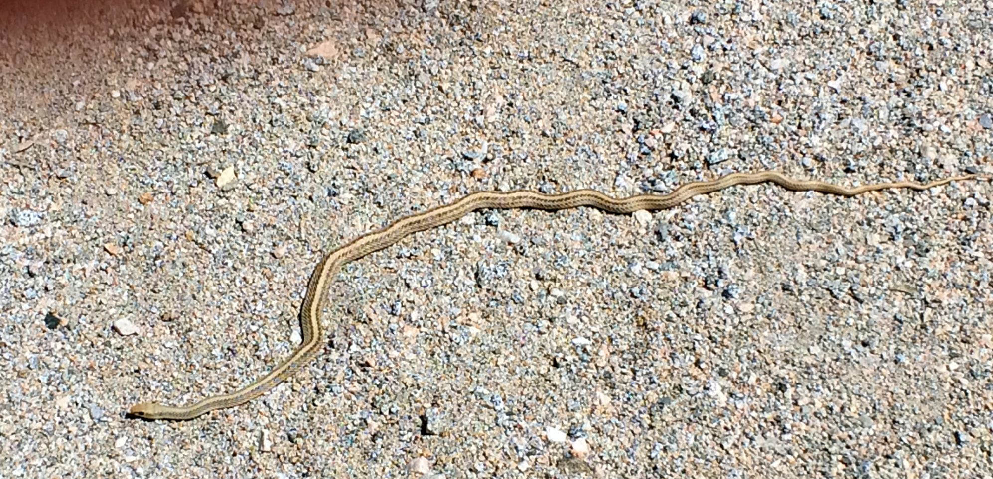
Snakes! One of two we spotted. I think this was a Coachwhip, as it suddenly moved so fats it scraed the crap out of us. The other was a Rosy Boa we saw on the ridgeline. A good snake day.
So, no plane crash but still a nice hike, about 10 miles overall. There are some other approaches I’m taking in an attempt to refine the location of N1586W, but they will take a little time to run through. But I suspect I’ll be out there again. Gotta have some sort of excuse.
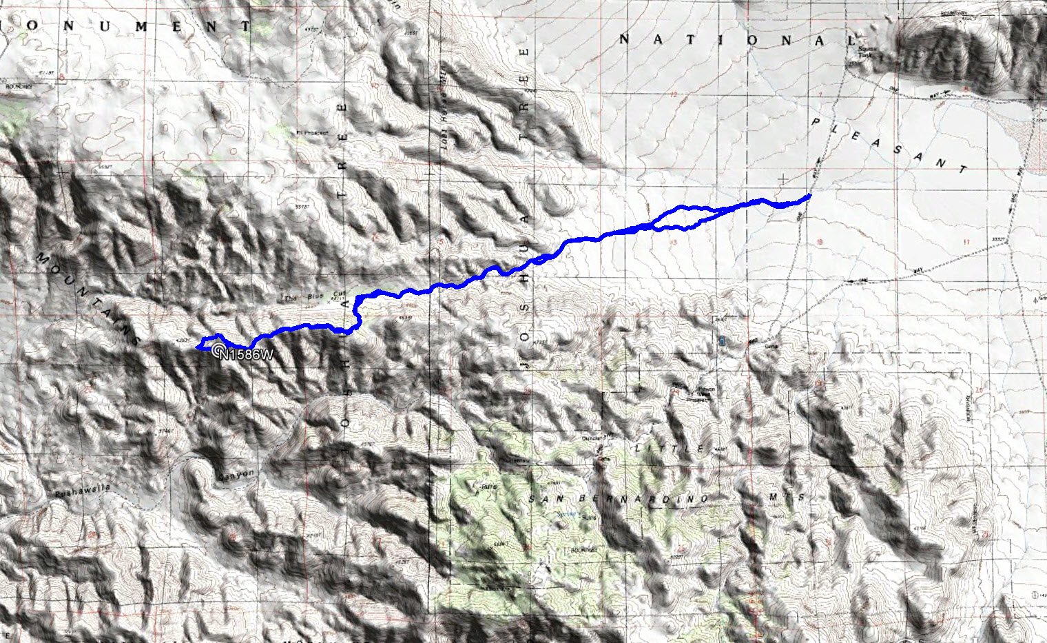
Our overall hiking route to the alleged crash site from Pleasant Valley.
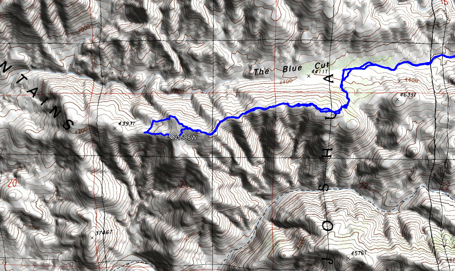
A detailed view of our hiking route near the coordinates.