Note from Tom: This search trip and writeup is brought to you courtesy of Adam Marsland. It’s his second trip. Do 10 and you get a free, used water bottle.
Date: 4/06/2013
Participants: Adam Marsland, Teresa Cowles
General search area: North side of Smith Water Canyon east and north of Covington Trailhead area.
Rationale for searching this area:
Previously unsearched area close to the cell phone ping range.
Since my first search of the area another possibility had occurred to me about Ewasko’s possible plans that could give him a reason to be on the largely ignored north side of Smith Water Canyon. From a cell phone ping standpoint, it’s one of the last unsearched areas that falls near the 10.6 mile radius.
Impressions of area and findings:
The approach that we took to climbing the north slope of Smith Water was difficult, but conceivable without hiking sticks (which Bill didn’t have but we did, and blessed repeatedly). When we tried to get back down at a point further up the canyon, the terrain was so steep and rugged we gave up on it. There may be easier approaches further up the canyon, but I didn’t see any on this trip nor my previous one.
Up at the top of the canyon, it’s a completely different story. The terrain is not terribly uneven nor overgrown for fairly large stretches, visibility is far (you can see Joshua Tree village clearly from this vantage point), and extensive ground can be covered fairly easily. It’s even scenic (there is, however, little cover from the sun). If Bill did somehow get up to this point, with the terrain this vast and easy, it would have been tempting to try to walk out to the north (as per Tom’s theory in the notes for JT37).
With Ewasko still not found, there has been more and more speculation that he just walked out of the search area completely, perhaps disoriented from dehydration. If he somehow got up here, perhaps from further up Covington Flat Road where the approach is less steep, the amount of places he could have wound up are nearly endless.
Coverage level:
Only fair. There were two of us, and we split up quite a bit and covered a lot of ground. That said, we did not get as far north as we had thought/hoped and were both acutely aware that, as said above, if Bill did blunder into this area, he could be about anywhere.
Comments:
The north side of Smith Water, with a couple of exceptions, has not been searched at all, and for good reason: it’s very hard to think of any reason for Bill to make the ascent. But there is cell phone coverage on the north side at nearly the 10.6 mile radius point, and after thinking through the case again, I thought I had two (non mutually exclusive) theories that could conceivably put him in the area. If nothing else, we would further narrow the unsearched area (though, because we were further south than we realized, not as much as we had hoped).
The starting point to these ideas was the question: why was Bill at Juniper Flats trailhead in the first place? Given his late arrival relative to his morning cell phone calls, and his stated desire to visit Cary’s Castle, it seems likely that it was not his first choice of destinations. Looking at the map, and thinking through my own experiences as a drop-in hiker/tourist, I thought it was suggestive that there was a range of interesting destinations within theoretical range of the Juniper Flats trailhead…Juniper Flats itself, Quail Mountain, Stubbe Spring and lastly, Smith Water Canyon. Quail Mountain and Smith Water were each on different lists of possible locations for Bill to investigate. My instinct was (and even after today, still is) that Bill likely chose Juniper Flats because, with the day getting on, it offered him the most “bang for his buck” to see multiple things during his limited time in Joshua Tree.
With that in mind, it seemed very possible to me that he had not settled on an actual destination when he set out from the car, and that he was going to play it by ear. So what if he had gotten as far as Juniper Flats and then not gone up Quail at all (or only ventured a short way and decided against it)? The California Riding and Hiking Trail offered (relatively) easy terrain and a potential second destination, Smith Water, with a place to refill Ewasko’s dwindling water bottles. More or less the same as Tom Mahood’s theory, but without Ewasko having gone up Quail in the first place.
I e-mailed this idea to Tom Mahood and he immediately shot down the idea of Smith Water as a primary destination: it was a 10 mile hike at the height of summer and there were two MUCH easier entries to Smith Water Canyon; at Covington Trailhead and at Park Road north of Quail Spring. True, I responded; but the road to the former was clear on the other end of the park, requiring an exit and re-entry. No way was that going to happen on a limited time frame. And the Park Road entrance, while not as far, offered no secondary destinations other than Samuelson’s Rock, and a pretty uninspiring slog to Quail Spring (there’s also no official trailhead there).
Be all that as it may, Tom convinced me that there’s no way Bill would have set out for Smith Water as his set destination from the outset…but it still seemed conceivable to me that he might have struck out for it in a “we’ll see how far we get” way from the Juniper Flats area and, as I have frequently done, underestimated the time remaining to get there in proportion to the amount of time already invested in the trail. And there was another, perhaps more likely, possibility as theory number two…if Bill had started to suffer sunstroke and disorientation, it was easy enough to imagine him just wandering down California Riding and Hiking Trail — the path of least resistance (well, the only path) — without necessarily having a conscious plan.
Be that as it may, once at Smith Water, a coherent Bill would be expected to strike out to refill his water supplies. At that point, he could conceivably have climbed the north slope (a) to take a picture of the canyon in the presumably fading light (he was an amateur photographer), (b) for orienteering purposes, or (c) to get a cell call out for help, since at that point he may have been 10 miles out from the car. A serious injury at that point could possibly have left him in a situation where he could only crawl up, to ping the cell tower 2 1/2 days later.
OK…detail-wise, the scenarios that put a sane Bill on the north side of Smith Water are a bit flimsy. But the rest of the idea has a few compelling components that are hard to shake. The Riding and Hiking Trail is almost entirely in the dark of the cell tower, which explains the most puzzling part of the mystery, the cell phone that didn’t ping until Sunday (and that, apparently, died as soon as it was turned on). It is also the quickest way to Smith Water, and it seems clear that somehow, someway, he got there. It’s the most obvious route for a disoriented person to travel; but if he’s compos mentis, once Bill has traveled far enough down the trail, his rationale for going on to Smith Water to refill his bottles is the same as it would have been on the approach to Quail Mountain…and his path there much safer. As to the “sunstroked Bill” theory, I couldn’t think of a good reason why a not-totally-rational Ewasko would wander up Smith Water Canyon from the trail until I got there, then I saw why: it’s substantially cooler in the canyon.
So even if the guessing as to the “whys” isn’t all that convincing, the possibility of Bill simply hiking up the California Riding and Hiking Trail to Smith Water, and out of the search area almost from the get-go, and then hurts himself, remains the simplest and most direct scenario to explain the Sunday cell tower ping.
Tom, helpfully suggesting that “I could stand to be wrong a few times,” gave the trip his blessing and I was off, this time with an old hiking partner, Teresa Cowles, for extra safety backup and an extra pair of eyes. This proved to be invaluable as she repeatedly spotted things I missed all along the trail.
We set off from Covington Flats Trailhead and headed up Smith Water for about 3/4 of a mile. We failed to find any water in that segment. Our plan was to put ourselves in Bill’s shoes, look for water, and then from there look for a good northside vantage point for photo bug Bill to take a hypothetical I-came-this-far-might-as-well-get-a-snapshot-before-I-go sunset picture from. Not finding water put a crimp in that plan. We instead ascended at the first half-decent slope we could find after that point. It was fairly tough going at first but it gradually got less so. It was conceivable that someone without a pole could make it…and indeed, Teresa found an old Snapple can in the brush that indicated at least one other person had taken this route before us.
The lay of the topography kept pushing us back towards the first big ridge east of the Covington trailhead, which I knew Tom had already searched thoroughly, so we attempted to move back to the north, with my goal being to keep going up until my phone (which is Verizon) pinged the cell tower. This was the same thing I tried on my previous trip, and like the previous trip, it did not happen until we were very high up, pretty much at a height of land from which we had a view of the lower lands to the north and east and Joshua Tree village beyond.
At this point, it was hard to know how to proceed, because if Bill had gotten to this spot, we wouldn’t know what condition he was in, why he was there, or what he proposed to do next. So we basically let the terrain guide us, keeping an eye for rock outcroppings and such (not nearly as many of these up here as on the south side of Smith Water). For the most part, the going was not difficult until we started to head north and east back towards Smith Water Canyon, where the terrain got too steep and rough to safely go further, at which point we turned west and then north, the idea being that if Bill had gotten up here for some reason, the terrain was easy enough that it probably would have compelled him to try to walk out to Joshua Tree. The thing is, it never really “felt” like Bill had been in the area (not like the first trip where at one point I felt like I was really close) but moreover, if he had wandered up here, he could be ANYWHERE. The amount of places that haven’t been searched that he could have walked to in this area, with relative ease, were vast.
We did find a few things, most significantly several parts of a skeleton near the point where we turned back from trying to descend back down into Smith Water. The vertebrae were large enough to be human. We bushwhacked around until we found the skull. I’m not sure what it was, but it had antlers, so I’m guessing it’s not Bill. We did find another bone early on, on the first ascent, but it was small and almost certainly from a critter.
There was slightly more sense of human passage than on my first trip to Smith Water; we were surprised to find footprints, including an eerily well defined (and isolated) male bootprint in a remote spot, not far from where the large animal skeleton was. Looking at Tom’s website, this may be a remnant of his only search in this area; it looks like he may have gone down this wash. We also found a Gatorade can, nearly entirely buried, in one of the flatter areas on the north end of our coverage area. But basically, nothing that could be linked to Bill.
My gut sense is that Bill isn’t to be found here, but I certainly can’t rule it out on the basis of today’s search. If he did wander up here somehow (and as I said the approaches are daunting, but the going is quite easy once you’re up), he could have gone for miles and miles and it’s no wonder he hasn’t been found. On that basis, this area may warrant further investigation, as per Tom’s notes on JT 37.
I took video of the trip, with me narrating increasingly less and less coherently as the day ground on, which I will put up as soon as one of us gets around to editing it.
GPS mileage for this trip: 6.6 miles
Cumulative GPS mileage to date: 676.7 miles
GPS tracks for this trip in Google Earth kml format
GPS tracks for this trip in Garmin gdb format
GPS tracks for this trip in gpx format
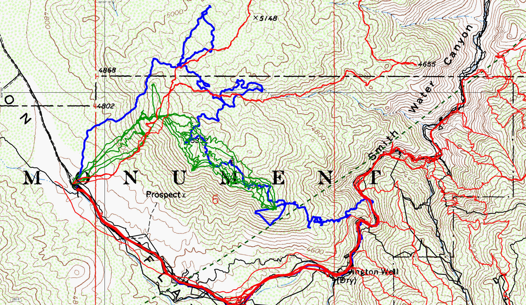
JT 50 tracks in blue, original search tracks in black, tracks since then in red and Mike Melson and company’s local tracks in green. The 10.6 mile Serin cell tower radius is the green dashed line.