Date: 6-24-2013
Participants: Tom Mahood
General Search Area: This was a hike on the third anniversary of Bill’s hike with no specific search areas intended. Primarily reflection and reconnaissance, following Bill’s presumed route to Quail Mountain.
I really wasn’t enthusiastic about doing this hike.
I had done the hike in to the base of Quail Mountain on the first anniversary of Bill’s hike, presumably along the route he took. It was hot, probably about the same temperatures he experienced. And I don’t like heat if I can at all avoid it. My ancestry is that of cloudy, cold places and I like it that way. But still, it was a good time to reflect and consider new ideas.
Last year, on the second anniversary, I was out of the state so no hike was possible then. Which brings us to this year. And I really didn’t want to do it.
Why? Well, there’s that heat thing. Now given a good idea of a place to search I’m OK with a summer hike, if that’s what it takes. But there’s that “good idea” part. I feel it’s been a while since I had any ideas I thought anything of since we crashed and burned so badly with my southeast mouth of Smith Water Canyon idea. And this sort of hike would just serve to remind me that I’ve still failed with each step. It gets old after a while.
So I decided to make this sort of a tourist trip, heading in to Juniper Flat, along Bill’s presumed route, and maybe have a look at where a bandanna was found during the initial search. I had the coordinates and knew it was at the base of Quail Mountain but I had never been there.
The bandanna find was interesting since Bill, who was balding, often hiked with them. I was told he sometimes would drop a bandanna during a hike to mark an important junction for the return. However other than a brief mention of the bandanna find in the original search records, there was no further info on it. Nothing about color, condition, nada. It could have been Bill’s or it might not. But the spot was worth a look.
My initial wacky idea was to start off on the hike around a similar time to what Bill might have, after 10:30 AM. But then I realized I’d run into all sorts of traffic getting out there and I hate traffic worse than heat. So I pivoted to the other side of the nasty traffic time and ended up at the Juniper Flats trailhead at 8 AM.
Getting out of the car was…well, a surprise. It was windy and almost felt like I needed a jacket. The forecast was windy and in the upper 80s but the morning was a little crisp. This is late June? I decided it would have to warm up and started down the closed dirt road that heads to Juniper Flat. I just zoned out and 1:35 later I found myself in the middle of Juniper Flat. Well THAT was certainly quick!
I shot a panorama and took a critical look at the terrain. Looking towards Quail Mountain there’s an obvious route right up its face. This is a sucker route. I know from experience it’s not what it appears. There’s a big canyon between the ridgeline and the final slope of Quail rendering that direct route not possible. Or at least really stupid. The smart route is to continue easterly across Juniper Flat and climb the ridge on its east edge. This ridge does a nice gradual ascent to Quail Ridge, just easterly of Quail Mountain. But if you wanted a no-nonsense route up Quail, consistent with what guidebooks describe as the “direct route”, and weren’t really familiar with the area, well you’d take the sucker route. Since this was pointed in the direction my GPS was giving me for the bandanna coordinates, off towards Quail I headed.
Right away I noticed there was a very pronounced use trail headed in my direction so I hopped on it and followed it. I figured it would soon veer off to the right and take a more intelligent approach to Quail. But no, it was headed for the sucker route.
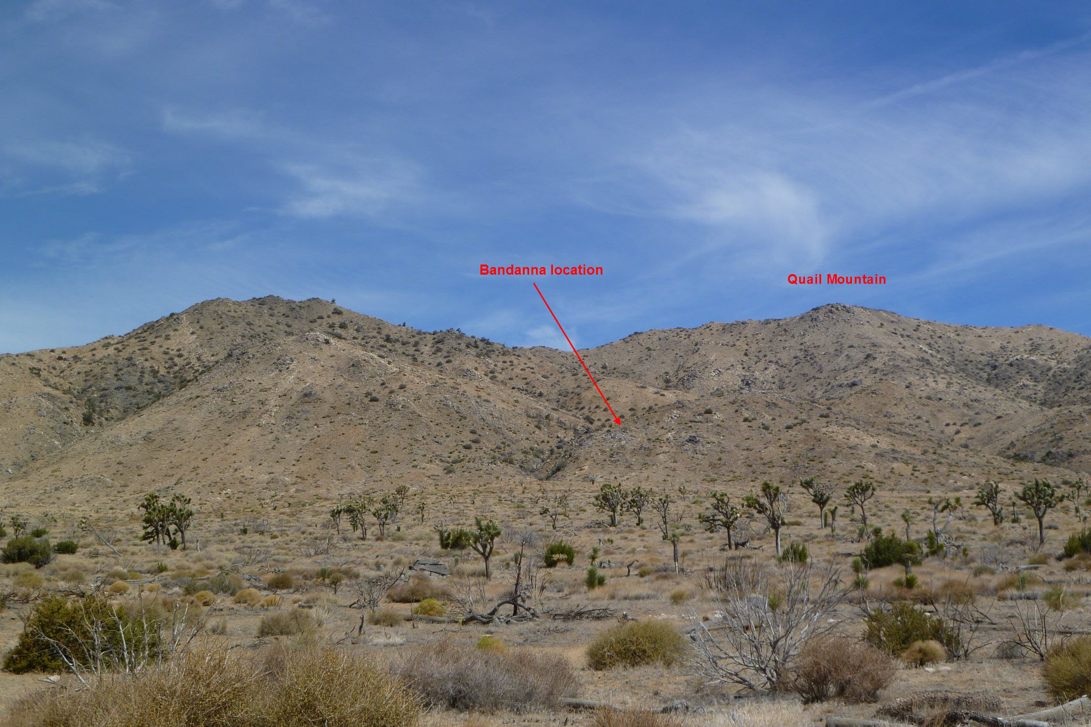
Looking toward the area the bandanna was found from Juniper Flat. The route up to the main ridge is along the ridge spine above and to the left of the bandanna location. You can’t go directly from the bandanna location up and right to Quail Mountain because there’s a large canyon in between that’s not visible.
As I approached the toe of the ridge spine I realized Patrick McCurdy and I had been just a few hundred feet west of my current path during JT16. I further realized that the bandanna location wasn’t on the flat part of Quail Flat, but was actually up the ridge spine just in front of me. A short climb later and I was at the bandanna site.
If anything its location makes it even more ambiguous. It appears to have been found smack on one of the well used routes up Quail, so anyone could have dropped it. Further, it’s not a spot someone would mark as a decision point on the return. So if it was Bill’s, it was dropped accidently. So the bandanna remains well in limbo as a clue. Maybe. Maybe not.
So as I’m looking around the bandanna spot I’m starting to realize a few things. First is that this really didn’t take me much time. Probably some of that was the cooler than usual temperatures but the rest of the way up to Quail didn’t seem that far (I know, another optical illusion). I was previously a bit skeptical that Bill would have proceeded up Quail what with the heat and the later start time. But if he was a “heat person” he probably would have been feeling about what I was feeling then. Also in previous trips up the Quail ridge I had been doing searching of other areas along the way so I was pretty beat when I arrived there. I think it colored my judgment in this regard. This little tourist trip was making me rethink the viability of ascending Quail in June. It wasn’t nearly as bad as I had thought.
I also had the sense that if Bill did head up to Quail Mountain, it was highly likely I was on the same route. It’s what felt right based upon the terrain. In fact, once you start up this route there’s only one way to go. And with the presence of fresh footprints and an occasional rock cairn, it’s clear this was a well used route. If I was planning a trip to the top of Quail Mountain for myself, I’d have been over on that ridgeline much further east. But if I wasn’t real familiar with the terrain, I’d be right where I was.
Checking on my Verizon cell phone, I had a decent signal on the ridge spine, probably coming up out of the Coachella Valley. And there continued a good signal all the way up. So if Bill did take this route he clearly had his cell phone off. This is consistent with the lack of any reported pings after he completed his morning calls while he was enroute to Joshua Tree.
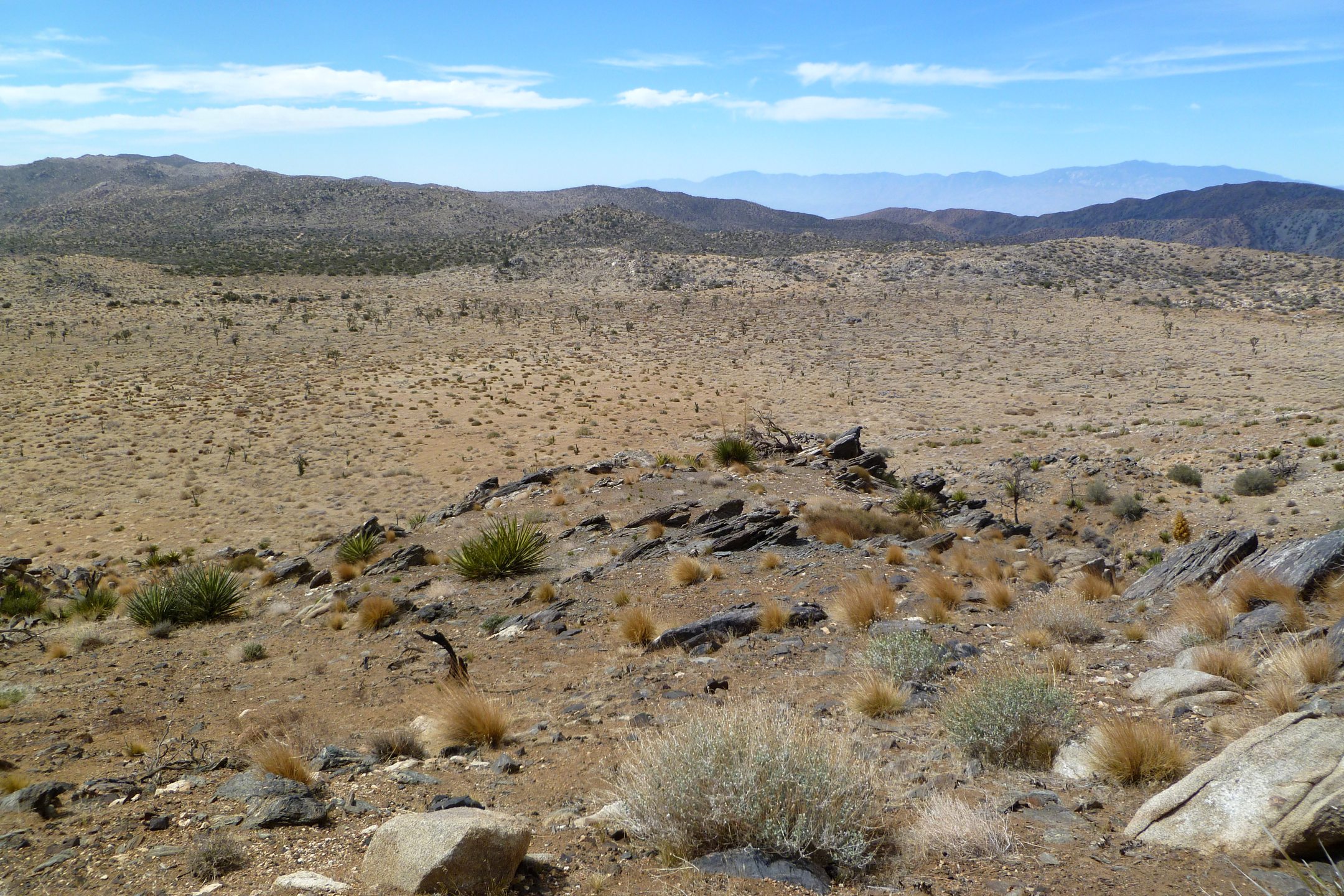
Looking out onto Juniper Flat from the bandanna location in the foreground. That’s the Coachella Valley off in the distance and Verizon cell coverage is starting from here on up.
So up I went, taking the only reasonable route, along the ridge spine. Shortly after passing the bandanna site the ridge spine gets high enough to see that big canyon I mentioned between where I was and Quail Mountain. I can imagine many a climber going, “Oh crap!” at this point. It becomes clear the route actually isn’t straight to Quail Mountain but rather curves away from Quail Mountain, heading westerly as the spine rises to Quail Ridge. It eventually gets up there, but about a half mile westerly of Quail Mountain.
I finally reached the local high point of Quail Ridge and checked my time. It was only 2:45 since I had left the trailhead and I was looking right at Quail Mountain only 0.4 miles to the east, a trivial walk. And on top of that I had stopped several times to look around, think and take pictures. I was beginning to think going up Quail in summer wasn’t as farfetched as I had originally thought.
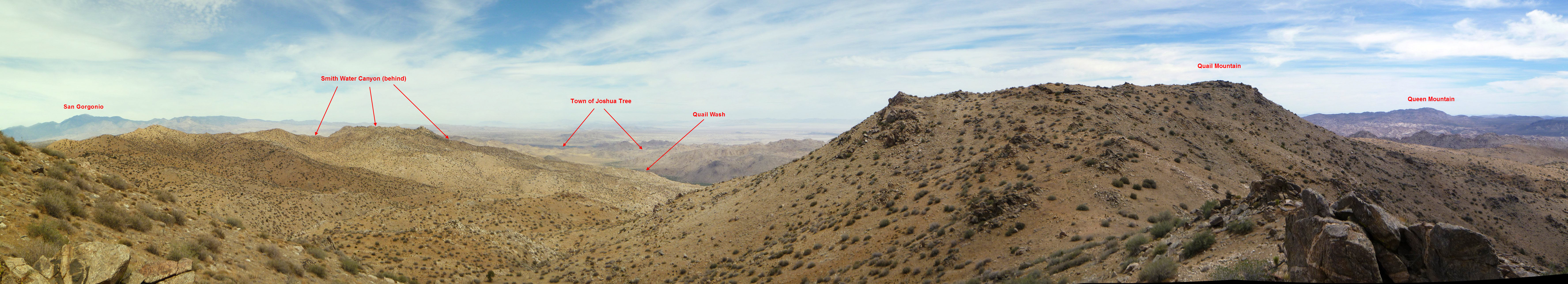
A panorama on the Quail Mountain ridge with landmarks annotated.
I decided I had already been to Quail Mountain itself enough so I didn’t bother heading over there. Instead I found a comfy rock, sat down and thought about things while taking in the vista. I couldn’t help noticing that to the northwest, seemingly very close, was what I knew to be the southerly rim of Smith Water Canyon. I looked over at Quail Mountain, then looked out to the Smith Water rim and it really didn’t look that far away. I later measured it on the map at 1.5 miles, still not far. Looking back down at Juniper Flats, from where I had just come up, reinforced the feeling that a cross country hike to Smith Water Canyon wouldn’t be too bad. And this is where I sort of scared myself. I started actually thinking about doing it.
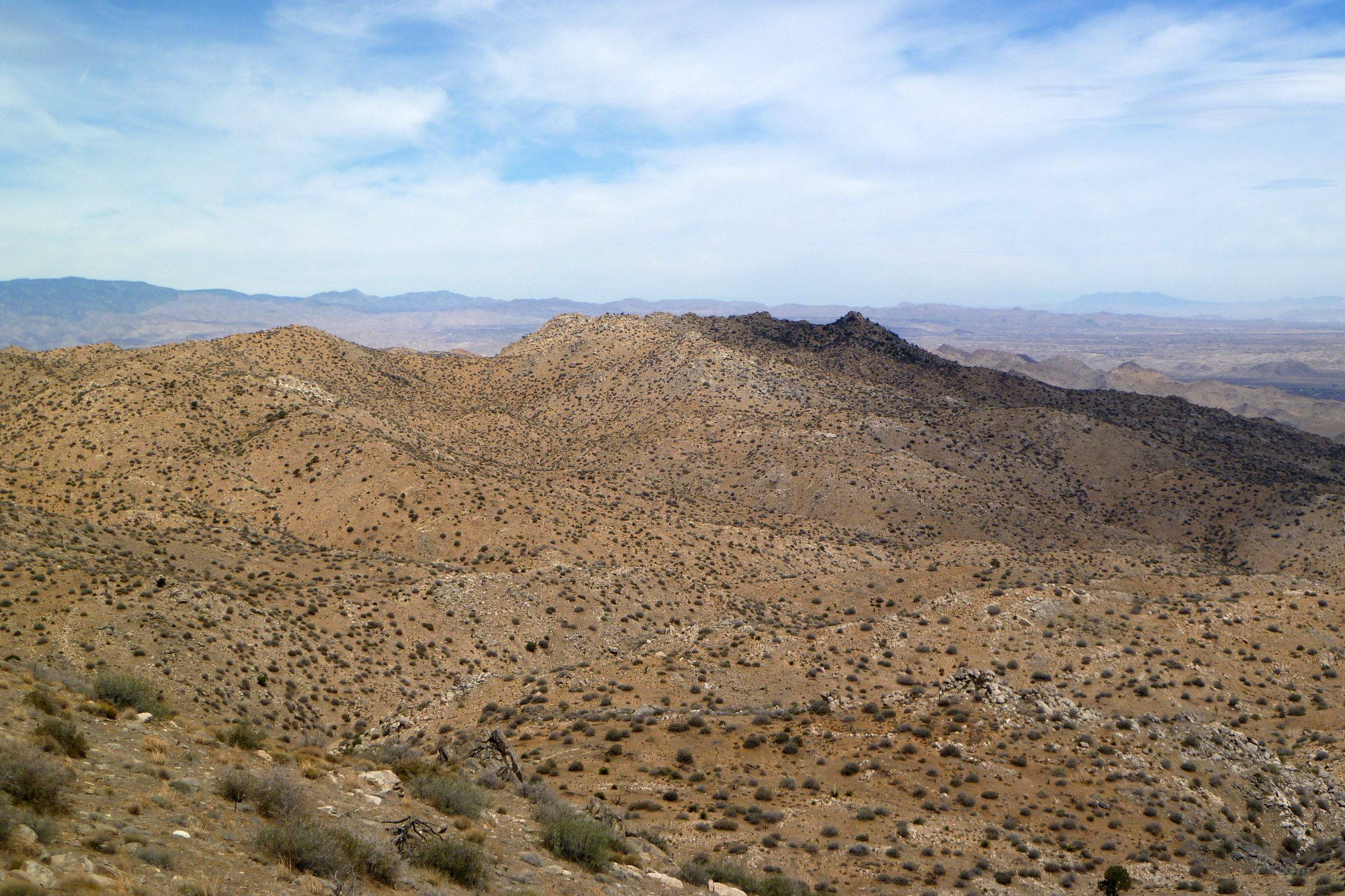
Looking toward Smith Water Canyon from Quail Mountain ridge. The ridge in the distance is the southerly rim of Smith Water Canyon. The camera is slightly zoomed to approximate what the view is to a typical human eyeball. This is pretty much what it looks like in real life.
Sure it would be a long hike, verging on epic. Head to Smith Water, drop into the canyon, head westerly in the canyon until meeting up with the California Riding and Hike Trail which runs back to the Juniper Flats trailhead. What I was seeing in front of me didn’t look too bad. The first part, descending off the ridge I was on was wonderfully open and gentle. It was calling my name!
Fortunately I got my binoculars out and scanned the cross country route in the distance. Immediately I saw all the boulder fields I had forgotten about and was reminded of how bad that area really is. But it wasn’t discernible to my naked eye. Also I had started the hike with 5 liters of water and I probably had used half. I figured I’d have enough water to make it to the bottom of Smith Water but just enough. And the idea of partaking of scummy water wasn’t too appealing.

A zoomed panorama looking toward Smith Water from the Quail Mountain ridge. The level of rockiness approaching the crest becomes apparent in this zoom. It’s not visible when viewed normally from this distance.
Taking a mental step back from the edge I started thinking about why this at first seemed a not unreasonable idea to me in late June. I mean, it sounds pretty nuts, doesn’t it? Well, I think mainly it was the wind.
Quail Mountain and its ridge are the tallest things for many miles around. If I was ever up there and it wasn’t windy I can’t remember it. Some places suck, Quail Mountain blows. And this wind, combined with the low humidity, makes it seem comfortable and much cooler than it actually is. However once descending out of that nice wind, possibly heading northwest, you find yourself in a furnace of still, hot air. And oh, by the way, you’ve now entered a huge cell phone shadow area. No coverage until you get near the rim of Smith Water Canyon, which happens to be around 11 miles from the Serin Drive cell tower. An unlikely coincidence in my opinion.
So as I was sitting there, considering my own foolish thoughts, I started thinking about how this could have gone with Bill.
First, I think he either ascended Quail via the route I just completed or he went off someplace so strange no one has yet an inkling of where it is. So let’s assume he went up Quail. If he was a strong hiker, used to heat, he could have been where I was in even 2 1/2 hours. But almost certainly he would have burned through most of the three bottles of water he is believed to have been carrying.
We know Bill knew about Smith Water Canyon, that it had year round water and it connected with the California Riding and Hike trail at its westerly end. Even if he scaled it off on a map, he would have found he was only 2 miles from the water. Looking out to the northwest, he could see most of the route before him and it looked better than what he had just come up. So why not try it? No need to make any phone calls as he wasn’t in any trouble. Just taking the long, scenic route back (’cause Smith Water is cool!) and picking up some water along the water. Sounds like an adventure! So off he heads to the northwest.
Now I’m told Bill was an old school map and compass kind of guy. So he would have either taken a bearing or sighted on a prominent landmark. Maybe a landmark such as the conical peak at the easterly portion of Smith Water Canyon. In any case I think he would have tried to hold to a straight line, something made difficult by the terrain.
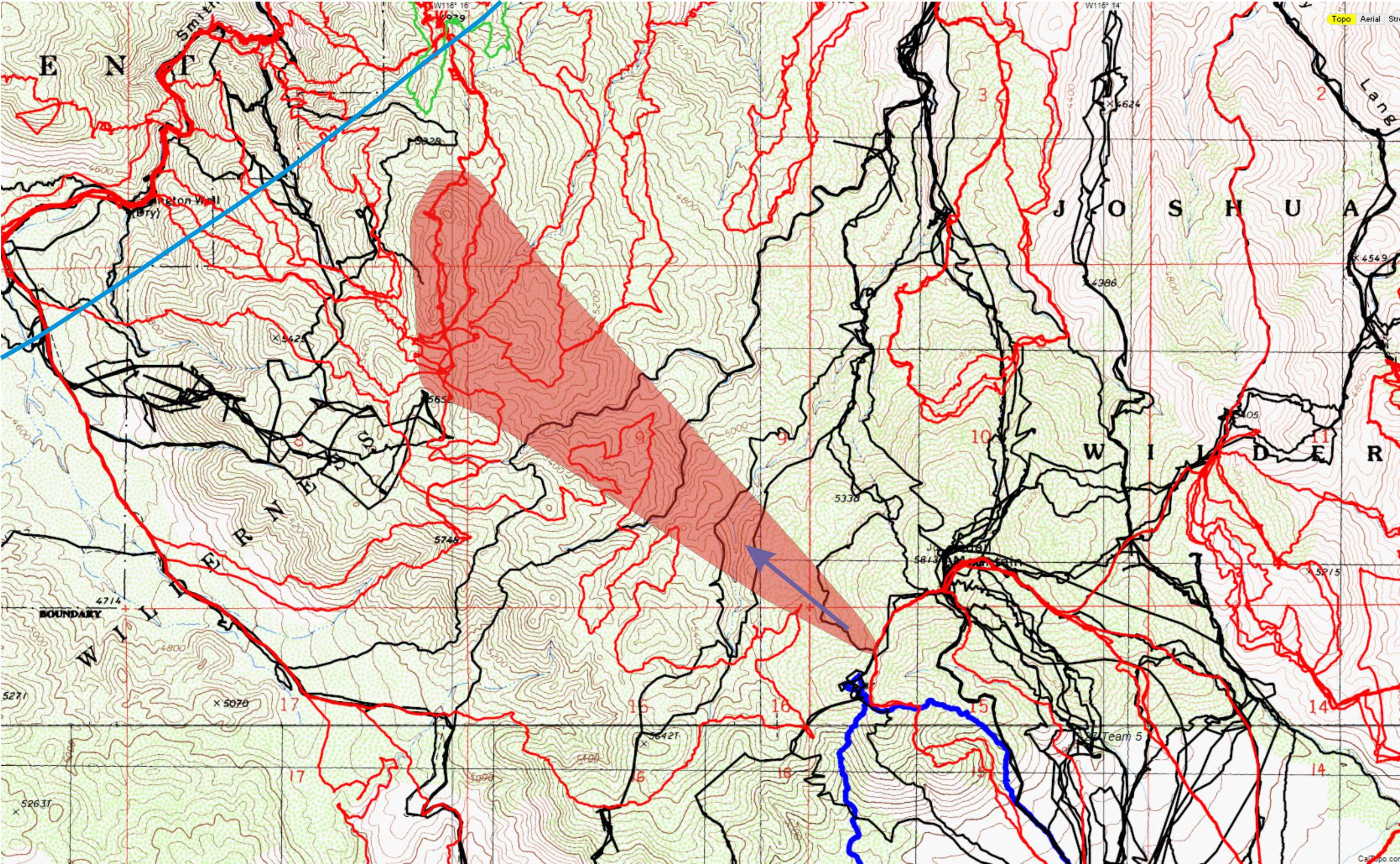
Viewing the terrain from the saddle on the ridge this is the general route I’d expect someone not fully aware of the terrain to choose. Black lines are original search tracks, reds are tracks since then and the cyan radius line in the upper left is the 11.1 mile radius from the Serin Drive cell tower. The red shaded area corresponds roughly to the zoomed panorama looking toward Smith Water.
At some point my hunch is he experienced some injury, perhaps as minor as a twisted ankle. Very easy to do in that terrain, especially if you’re trying to hold a bearing rather than follow the contours of the land. And by then the still dry air would have caused him to finish his water supply. Finally, no cell service is to be had. A serious survival situation has now been created.
So what are the options? Well, he certainly could have returned the way he had come. But if whatever befell him occurred when he was well towards Smith Water the prospect of going back up and over the Quail Mountain ridge and making it all the way back to the car would have been VERY daunting. And no water the entire route.
If he turned right and started down the drainages to the Samuelson’s Rocks area and to the even further Park Road, that was many miles. And again, no water. Water equals survival so that’s the priority. Add to that it was completely unknown territory.
So the only option that’s left is to press on to Smith Water Canyon and water. Sure it’s a risk, but it is, as they say, your only chance. This resonates with me because frankly, it’s what I would have done. I’m not saying it’s the best thing to do, but I would have taken that gamble (although I might have eventually tried getting to the highest spot I could find to use my cell phone). The nightmarish aspect of this option is that the closer you get, the worse the terrain gets. But you don’t find this out until it’s too late to do anything else.
Clearly, if this is the scenario, Bill didn’t make it. But it would explain the strange cell ping on Sunday morning. The distance of 10.6 miles puts it either on the edge of Smith Water Canyon or just in it.
I and others have spent considerable effort exploring the southern slopes of Smith Water Canyon based upon this premise, and so far, nothing. I’ve found that extremely discouraging as the obvious locations have been cleared. But perhaps locations we felt were unlikely when viewed from a perspective of approaching from the north, west or east turned out not to be so if approached from the south?
So what did I take away from this trip? I think Bill leaving the Quail Mountain ridge, heading northwesterly towards Smith Water Canyon and not making it is still the most viable scenario. Granted that brilliant idea is hindered a bit by the fact we haven’t found him there. But perhaps he’s in an area we have yet to search. And that amount of area is getting smaller and smaller. Certainly he’s someplace that’s not visited, otherwise he would have been found by now by a cross country hiker.
My sense (my fear?) is that when Bill is eventually found it’s all going to seem so clear in hindsight. And I’m going to whack myself on the head and ask, “Duh, why didn’t I think of that??!”
After my ridgeline meditations I dropped back to Juniper Flat via a drainage that had never been searched and blasted out of there. I was back at my vehicle by 1:30 PM for a total trip time of 5:30, which included a lot of sitting around. So Bill could have conceivably left the trailhead after 10:30 AM and still been out of the park by 5, his original plan.
I look forward to Fall…..
GPS mileage for this trip: 12.8 miles
Cumulative GPS mileage to date: 706.9 miles (breaking 700 is a depressing milestone!)
GPS tracks for this trip in Google Earth kml format
GPS tracks for this trip in Garmin gdb format
GPS tracks for this trip in gpx format
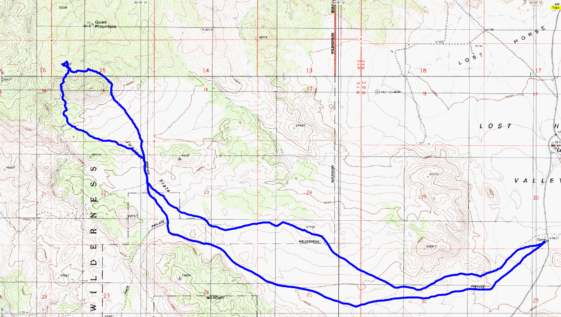
The overall route of JT53
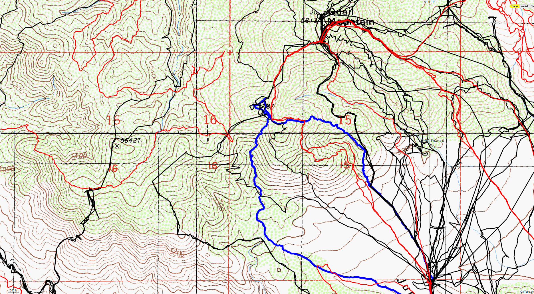
A closeup view of the area covered by JT53 in blue. Original search tracks in black, tracks since then in red.