Date: 11/07/2013
Participants: Tom Mahood
General search area: The ridge making up the southwesterly perimeter of the central bowl area of Smith Water Canyon.
Rationale for searching this area:
This was just sort of a housekeeping effort to fill in some blank spots in the search coverage. While it was fairly close to the 10.6 mile Serin radius, it seemed unlikely to be fruitful. But it would have bothered me had it not been crossed off the list. Also the terrain is fairly benign so I anticipated it to be rather simple and safe as a solo outing. Um, yeah. Right.
Impressions of area and findings:
As expected, nothing much to be found other than a few more Big Horn skeletons. The number of dead Big Horns in Smith Water Canyon is quite impressive. And maybe just a little bit disturbing.

A very complete Big Horn Sheep skeleton.

Another Big Horn skeleton less than 200 feet away. This region of the park is a phenomenal Big Horn graveyard.
I spent considerable time sitting on the ridge top and scanning the southeasterly portions of the bowl with binoculars. Viewing was excellent and I could easily cover acres and acres of terrain. It was disappointing not to see anything non-natural. Granted there were nooks and crannies I couldn’t see into, but much of it was very visible. The only way to really know for certain is to get eyes on the ground in that area. That doesn’t look to be fun.

A panorama of the eastern parts of the bowl. The view is towards the northeast and shows the variety of chutes around the edges of the bowl. The reported odor location coordinates are on the descending slope in the middle of the picture.
Another thought I had while looking over the bowl is that the most dangerous parts of the terrain (i.e., where someone would be most likely to get into trouble) were not only near the top of the bowl, but also in the last hundred feet or so before the very bottom of the bowl. The terrain in between these areas was generally not too bad. I hadn’t considered the low terrain in a scenario, where the slopes “cliffed out” just before the bottom, but now taking a careful look it seemed an area worth checking in the future. It is totally possible someone could get all the way down the slopes of Smith Water and take a nasty fall so close to being at the bottom. That would suck.
The central and easterly parts of the bowl continue to look plausible as a source of the cell ping. The westerly part, where I spent most of my time on this trip, felt too low and blocked by the northerly slopes of Smith Water to get a signal out. So all in all, this bowl area remains my target area of choice at this time.
Coverage level:
The usual, with coverage about 80% within 75 feet of my travel path at a minimum, and in a few areas a much wider area. I think my 50 meter swath reasoning continues to hold for this search.
Comments:
This was NOT a good trip. It started off badly by running into a big traffic backup heading out on I-10 which delayed the start. Then I managed to lose my favorite Oakley sunglasses during one of my stops to scan the distant east bowl slopes with my binocs.
Finally, I was about 2/3’s done with my planned route and generally headed back towards the canyon mouth, but up on Smith Water’s side slopes. The terrain wasn’t especially challenging so I was just tooling along. I spotted an interesting flower just below me and wanted to get a picture for Jeri. As I turned and stepped down on a rock I found it had a slick coating of soil and my feet went out from under me.
Now this sort of thing has happened to me too many times before and almost always ends painfully. As I was going down my mind was instantly doing the math and I figured this was going to be painful, but nothing serious. At the same time I was automatically slamming down the hiking pole in my right hand in an attempt to stop my butt-plant.
In theory, this was a wonderful idea and would have been an excellent course of action. Of course the theory failed to take into account the presence of a god damned yucca plant on my right side that I hadn’t noticed. They are sneaky like that.
So….I managed to bring my right wrist hard on to a yucca blade. Now I’ve been poked by those damn things more times than I can recall, and they hurt like a bastard. And occasionally I get blood running down my leg, which can be a bit messy. But I’ve never experienced, until now, a puncture that shot blood (my friggin’ blood!) a good 18″ across my pants. It was a spurter! This was, umm…disconcerting.
Now I don’t remember a whole lot from my wilderness first aid training, but one thing that’s been burned into my brain is when you see red stuff coming out, firm pressure cures damn near anything.
The gusher didn’t last long as I immediately slammed my left hand over the puncture and applied pressure. I don’t think it took more than a second and a half to do so and it’s sadly become almost an autonomic reflex. When I do this stupid-ass shit Jeri always asks “How bad is it this time?”, and I usually reply that I don’t really know, I didn’t have time to look at it.
I sat there on my ass for about 10 minutes with my hands over my head with my left hand maintaining a death grip on my right wrist. I was marveling at the amount of wonderfully bright red blood sprayed across my pants and mentally running through what I had in my first aid kit to deal with this. I don’t recommend mainlining yuccas.
After way too much time had passed I cautiously began peeling my left hand away (I was wearing my leather Petzel rappelling gloves) bracing for another spray. I was pleasantly surprised to see it had completely stopped. This pressure stuff works great!
The hole looked to be around 3/16″ across, rather small and innocuous for the amount of blood I had been sprayed with. Not a very manly wound at all. Unfortunately I didn’t have any clear water to rinse the wound, only flavored drink, so I just applied some Neosporin ointment, slapped a non-stick pad over it, covered it with a Bandaid to hold the pad in place and wrapped the whole thing tightly with a Coban wrap to keep the pressure applied.

Aftermath of the yucca attack after the bleeding was staunched. What? It doesn’t look that bad? Ummm..You’re right it doesn’t. I’m such a pussy….
I figure that was as good a reason as any to end the day so I started a descent to Covington Well to get the hell outta there. It was pretty easy until almost to the bottom. Remember my observation that the most dangerous parts of the bowl were the very top and the very bottom? Yeah, this was a good underscore to that.
I was probably less than 40′ above a nice, flat and sandy stream bottom, but the slope I was on was cliffing out. I finally found what passed for the least bad way down and ended up sliding down a very loose and crumbling slope, on my ass, with my hiking pole poised for a self-arrest. Not especially dignified. When I reached the sand at the bottom I breathed a sigh of relief and thought about how easy it would be to get seriously hurt in the very last portion of a Smith Water descent. Something new to think about anyway.
GPS mileage for this trip: 5.5 miles
Cumulative GPS mileage to date: 735.2 miles
GPS tracks for this trip in Google Earth kml format
GPS tracks for this trip in Garmin gdb format
GPS tracks for this trip in gpx format
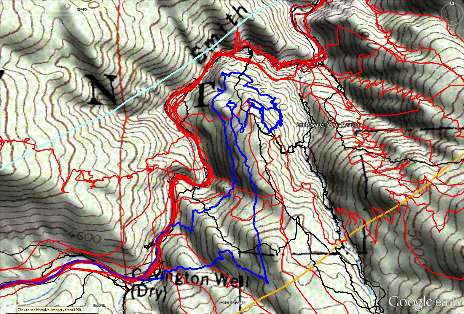
Overall tracks to date in the central Smith Water Canyon area. The black tracks are from the original search, red tracks those made since since, and JT58 shown in blue. The light blue line is the 10.6 miles radius from the Serin Drive cell tower and the orange line the 11.1 mile radius.

Overall tracks to date in the central Smith Water Canyon area showing a 50 meter swath of visual coverage. The darker the color the better visual coverage that area has received.
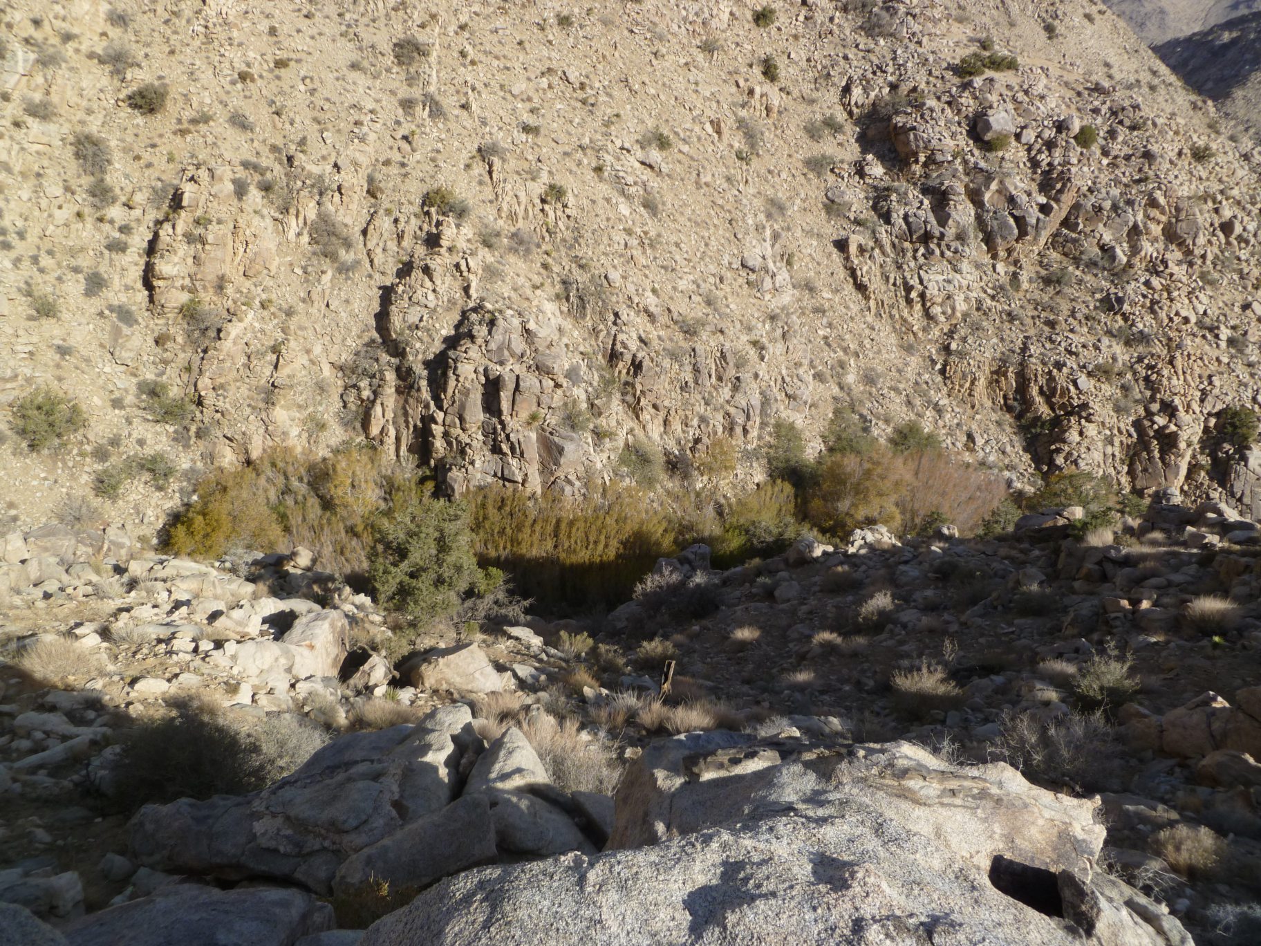
Looking down at the westerly Acacia grove in the bottom of Smith Water Canyon. This is the location that water, murky though it may be, can be found year round. This is also the location that these damn plants will rip the skin from your body. I like being up here.