Date: 11/17/2013
Participants: Tom Mahood, Patrick McCurdy
General search area: The upper and easterly portions of the central bowl area of Smith Water Canyon.
Rationale for searching this area:
This was intended to fill in blank areas in the search coverage to date in the central Smith Water Canyon bowl area.
Impressions of area and findings:
This area just feels right. We spent some time at the top of the bowl, looking down into it, and it seems to fit all the clues as we presently know them. It’s remote, VERY dangerous, around the 10 to 11 mile radius and could have possibly been a destination for Bill. So why haven’t we found him? That’s a damn good question, one I don’t have an answer to.
The terrain is very…..convoluted and broken up. There are lots of nooks and crannies, as well as dangerous drop offs. One would expect someone attempting a descent to the bottom of Smith Water to take an obviously easy route. Those were the sort of routes we took on our earlier trips down these slopes. These current search tracks we are making are what I call “brute force” routes, where we are just filling in the blanks on the map. So between our early trips and these current ones, we have some pretty good coverage of the bowl area. Of course it’s not perfect, as there as some many places to hide here. But still, we’ve probably covered 75% of so of the bowl area.
It IS maddening.
Coverage level:
Coverage is estimated to be about 80% within 75 feet of our travel paths at a minimum, and in a few areas a much wider area. I think my 50 meter swath reasoning continues to hold for this search.
Comments:
I thought I was sticking Patrick with the nastier of the two routes we covered, as I usually try and do that. Unfortunately I misjudged this time and he was at the bottom snoozing while I was still stuck up on a ridgeline, looking for a way down. As a result I am getting a bit more interested in this “last 100 feet” concept I’ve been exposed to the past couple of trips.
What I’ve inadvertently found is that upper reaches of Smith Water Canyon are somewhat hairy, but it’s usually possible to find a line down. The middle portions are OK as long as you don’t do anything obviously foolish like try and descend in a chute. It’s so much easier and safer to stay on ridge spines instead.
The problem is when you get within maybe a hundred feet of so of the bottom. The flow in the canyon has cut some pretty decent cliffs in most areas making the very last part of the descent the worst. Now that’s not true everywhere, but it is in a lot of cases. And it’s usually fairly close to the 10.6 mile radius.
I’m thinking this last hundred feet above the canyon bottom on the southerly side needs to be looked at. This might be most safely done by climbing up the northerly slope, at intervals, and scanning the southerly slopes with binoculars. Seeing as how there’s not a whole lot left in the bowl area within the 11.1 mile radius to clear, this might be an effort coming up soon.
Oh yeah…and no blood this time so not a bad trip!
GPS mileage for this trip: 13.0 miles
Cumulative GPS mileage to date: 748.2 miles
GPS tracks for this trip in Google Earth kml format
GPS tracks for this trip in Garmin gdb format
GPS tracks for this trip in gpx format
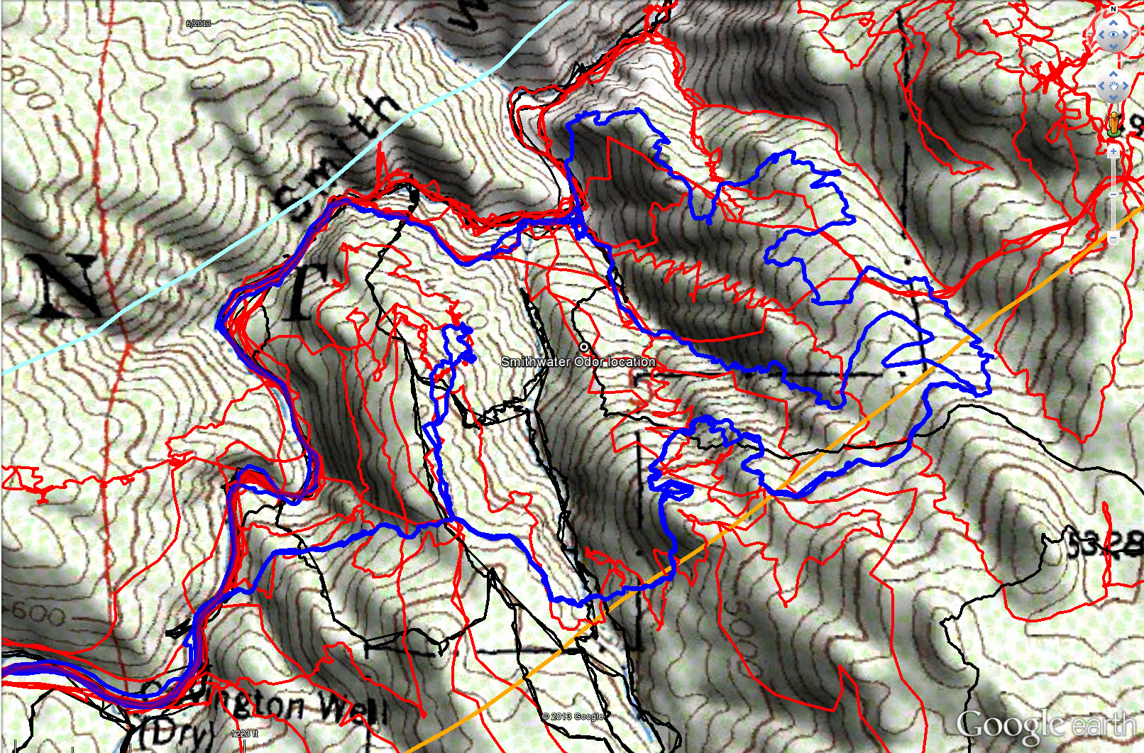
Overall tracks to date in the central Smith Water Canyon area. The black tracks are from the original search, red tracks those made since since, and JT59 shown in blue. The light blue line is the 10.6 miles radius from the Serin Drive cell tower and the orange line the 11.1 mile radius.
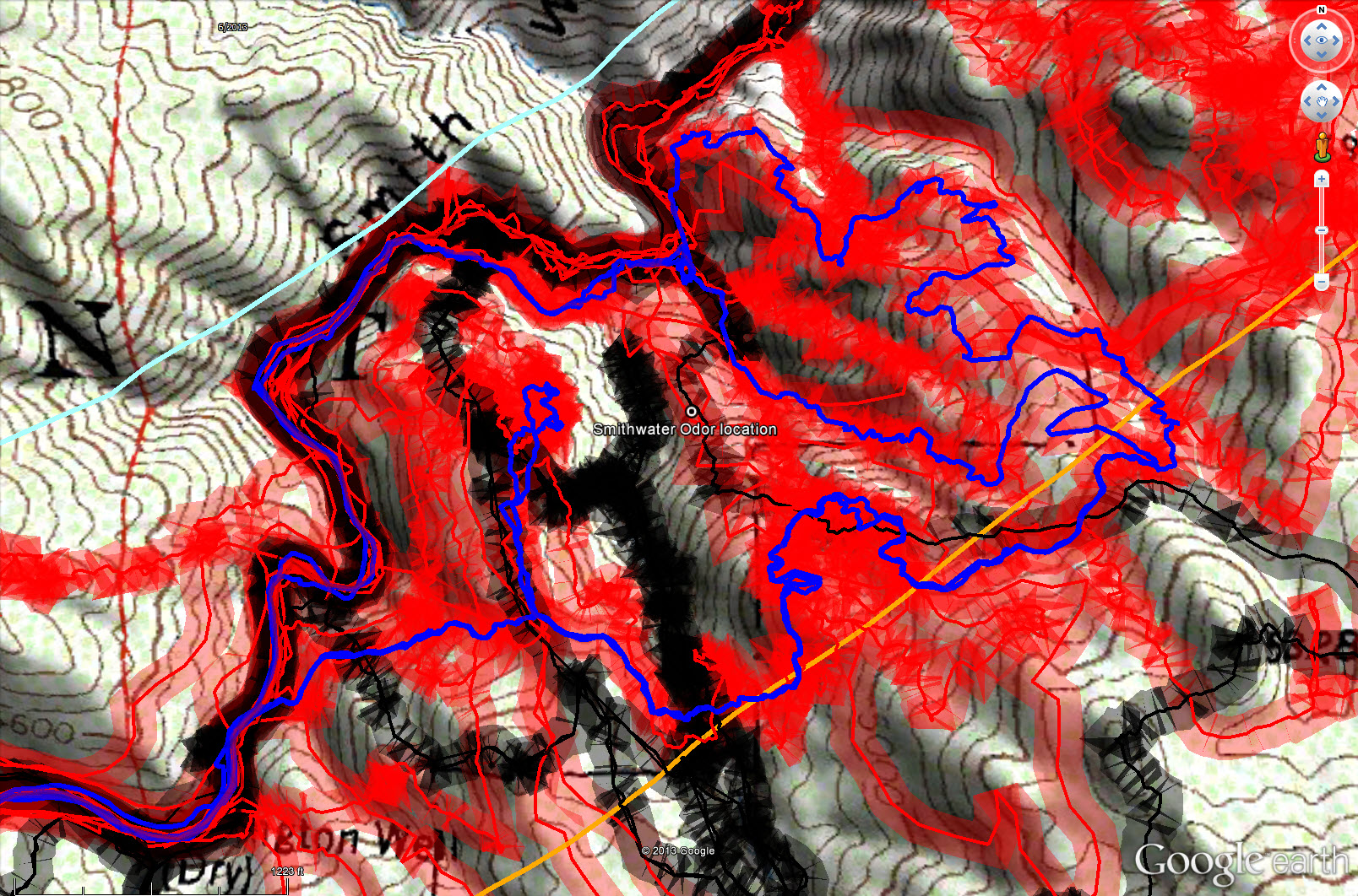
Overall tracks to date in the central Smith Water Canyon area showing a 50 meter swath of visual coverage. The darker the color the better visual coverage that area has received.