Note: Report written by Adam Marsland
Date: 3/22/2014
Participant: Adam Marsland
General search area: Ridge and slope southwest of Covington Trailhead
Rationale for searching this area:
Since my last trip to the area, something’s really been nagging at me about the Bill Ewasko search, and the recent mysterious loss of the Malaysian plane, with its oddly similar data points, brought it into focus.
I still believe that the most likely source of the cell ping is the spot that Tom and I visited on consecutive days in JT51 and JT52, a thread of cell coverage on an open spot above Smith Water not far from the 10.6 mile radius. And I still think the most likely place for Bill to be found is in the steep hills above Quail Spring, where I tried and mostly failed to search my last time out, five months ago (which is slightly different from Tom’s opinion, which is just as well, since there’s no point in us looking in the same place).
But.
We’ve all focused on the location of the ping, and what it tells us about where Bill might have been and where he was going. But perhaps as important as the where is the when. 10.6 miles from the tower puts Bill about that same number of miles, give or take, from his car. Bill disappeared on Thursday. The cell ping came at first light Sunday morning. That means that Bill was out for three nights. And yet not only has no confirmed trace of Bill ever been found, but no trace of any place he might have bivouaced, either. There are lots of places high up above Smith Water that would make swell places to camp for the night. And it’s fairly easy to guess from examining them whether somebody, man or critter, has put in any time there. And yet no such trace has been conclusively found, by any of the searchers, at any time. Nor any water bottles or possessions or anything else. That strikes me as a little odd.
But the thing that has really been nagging at me, and I finally was able to put my finger on it, is that Smith Water, while a good further from Bill’s car than would be expected on a day hike, is not that far, even accounting for the rough terrain. I unwittingly blundered halfway back to Quail Mountain from Quail Wash on JT55 and that only took a few hours. We’ve all scratched our heads over what could have befallen Bill that he’d be incapacitated out of cell range for 2 1/2 days before he was able to ping the tower. But there are only a few places that that ping could have come from, and they’ve been pretty well searched. He’s not in the immediate vicinity of those spots. So how is it that Bill is so injured that it takes him 2 1/2 days to cover anywhere from 1 to 10 miles (depending on where this hypothetical injury occurred), and yet as soon as he’s pinged the tower (and at the point when the search and rescue has begun in earnest), he’s so able-bodied that he disappears from the scene to points unknown, never to be found? The timeline doesn’t seem to add up. It requires him to be stuck in a fairly small area for two days, then ping a tower in passing, and then immediately vanish some inaccessible place when your only logical exit points are obvious and well-traveled. Or some other equally weird scenario.
So, back to what’s been bugging me. We know there was another hiker that was lost around the same time and area as Bill who eventually was found. That person related of wandering around for days in a daze, not really sure where he went or why (Note from Tom: That was Ed Rosenthal, missing in the Black Rock area in September, 2010. More here) .
But that doesn’t seem to apply in Bill’s case, because from the Quail-Smith Water area, there’s really nowhere to go. You either stay in the highlands or come down, and coming down means the canyon, Quail Wash, or the Samuelson’s Rock area heading towards Park Road, all of which are heavily traveled areas. There’s no point in going back to Quail Mountain; that’s where you’ve come from. And once you’re on the high ground, you can see the way out, so no reason to stay in the highlands, unless you are waiting for a helicopter (a defensible strategy, and there are plenty of places to do it, but he doesn’t seem to be in them). There’s nowhere to wander to; nowhere to go but down. And indeed, the devil in this area is getting down. It still is the most likely scenario; a catastrophic fall trying to get down from the highlands above Smith Water. But…
The only place where one could theoretically wander forever is the area south of Covington Flats, west and/or south of the overall search area. And that’s what’s been nagging at me. And then pondering the Malaysian Airlines question, with its mystery of pings and maximum flight ranges, it hit me: what if Bill was never injured at all? What if he never went to Quail Mountain at all? What if, instead, he got off the trail closer to his car (perhaps at Stubbe Springs, as Tom and early searchers had theorized), heading west, and had actually been wandering around down there, trying to get out, for two and a half days? What if the ping was actually Bill, having fought his way clear of no man’s land, on his way back to his car? That made a lot more sense — if Bill was off in the rugged lands west of Juniper Flats, it would explain why no trace of his passage had ever been found. It would also make sense of the odd timeline. It wouldn’t tell us where Bill was, since there’s still that pesky 10.6 mile radius to contend with, but it would suggest different places to look and different motivations for being there. This was the half-formed idea that I went to begin to check out, and though I wasn’t totally sold on it at the time, a closer look at the map on the return home does make it seem like it could be a possibility. I also had other reasons for wanting to search this area, more on that to follow.
Impressions of Area and Findings:
The height of land between Covington Trailhead and the adjoining flat to the west is not terribly steep, and once you’re up, it’s fairly easy to negotiate and pretty country to boot. Once I got to the top, the obvious flaw in my theory became apparent: there’s a road in the adjoining area west that runs quite a ways down south to Upper Covington Flat, and if Bill did come up through the mountains from the south or west, wouldn’t he come upon and then stick to that road? Probably. But help — and his car — would only be accessible by getting over the hill to the Covington Flat area (and consider that if Bill was still able bodied Sunday morning and was the directed individual he is supposed to have been, he may have still been thinking in terms of getting back to his car), and though there is a connecting road, it is pretty far to the north. Likewise the terrain south of this height of land, and the canyon that connects the two flats which lies opposite Smith Water Canyon, is pretty rough (and well south of the ping zone). The topo map says there is a connecting trail from Upper Covington to the Riding and Hiking Trail, but I couldn’t see it from where I was. At any rate, the ascent in the area I was searching did not look too bad. So it is conceivable that Bill might have crossed over this area, and possibly pinged the tower coming over, though it would be closer to the 11.1 mile range. I got plenty of bars wafting in and out of my Verizon phone, and even a little 3G, but I couldn’t get a text out. It’s a borderline area. So that part fits.
The other interesting thing is despite the close proximity to the Covington trailhead, and the comparatively easy terrain, it soon became clear that no one ever comes up here. With Smith Water and the California Riding and Hiking Trail readily available nearby, there’s no reason to. Signs of human passage were nil. As far as I know, no one had ever searched this particular area, and I saw no indication that anyone had ever been there. There also were fewer dead animal bones than usual, though I saw multiple tracks (including one paw print).
Coverage Level:
Fair. I was on an amble, and I took my time to look around, but there was plenty of ground I didn’t cover. With the exception of a balloon and some odd contraption with two narrow plastic flasks found near the bottom, there was nothing man made at all. Anybody wishing to expand on the search could do it easily in a few hours. It’s pleasant country and not at all inaccessible.
Comments:
This hike was undertaken on the way home on the last day of a 30 day road trip around the country doing my day job. In the course of my travels a number of folks had asked about Bill. I did not realize to the extent people had followed this story and in fact one friend had stumbled across the story on Tom’s page not realizing I was involved. It made me feel a little bad that after the flurry of activity last fall there hadn’t been much on-the-record searching, and it made me want to dip my toe back in again. But the last trip out, where not only had I failed to hit my intended search area but I couldn’t even find my own car on the way back for the third time in a row (and it had a flat tire to boot) had left a bad taste in my mouth. I tuckered myself out, looked like a fool, and didn’t accomplish very much. And I had a friend who happened to a stringer for NPR with me to witness it all. No fun.
After 30 days living out of my car, I was stiff and flabby, not to mention tired and ill-provisioned. I didn’t feel particularly up for anything too risky and I darn sure wasn’t psychologically or physically ready to slog my way back up to Park Road from Quail Wash and fumble around for my car in the dark one more time. So I needed something relatively easy that would still contribute in some way to the search. Clarifying my vague ideas about the unknown (to me) area south and west of Covington trailhead by getting a first-hand look at the terrain, and searching the low mountains southwest of the trailhead, filled the bill.
I honestly did not buy my own theory that much, but I enjoyed the hike a great deal. It was fairly easy going, the landscape was pretty, and although I didn’t feel like Bill was lurking around the next bush, it didn’t feel like a total waste of time either. And after surveying the landscape and checking out the map on my returning home, I’m starting to feel like this idea — that Bill might have been ambulatory and wandering around west of Stubbe Spring for the first two days — might have some merit to it. It does seem to fit the few facts we have a little better, not to mention it’s more logical geographically to where Bill parked his car, though it is a bit odd that he would have gotten so far into the wilderness that he was lost for two days, and that he then would have wound up that far north. Odd, but not impossible — and something odd did indeed happen. I don’t know if today’s search area would be the place to look but this scenario might conceivably mean that after pinging the tower Bill could have crossed Covington Flat Road over to the north side of Smith Water heading for Joshua Tree, or headed up the Covington Flat Road, as Tom theorized in JT37 and elsewhere. It doesn’t exactly change the basic problem, but it does offer a new perspective to attack it from, and new possibilities to think about.
GPS mileage for this trip: 4.3 miles
Cumulative GPS mileage to date: 755.8 miles
GPS tracks for this trip in Google Earth kml format
GPS tracks for this trip in Garmin gdb format
GPS tracks for this trip in gpx format
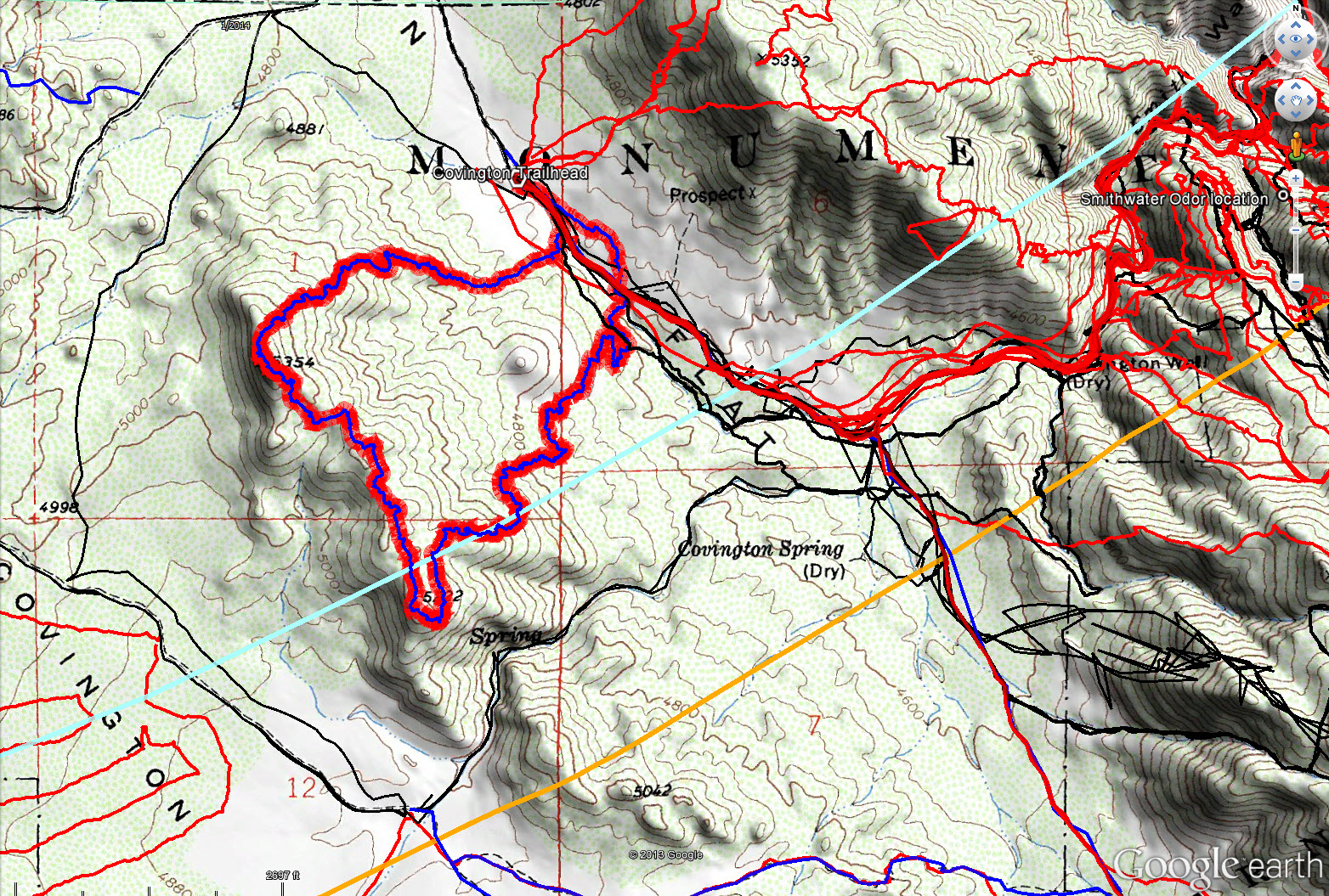
JT61 tracks are shown in dark blue with the theoretical viewscape as a red band. The original search tracks are shown in black, and searches since then are shown in red. The 10.6 mile radius is the light blue curved line and the 11.1 mile radius is the light orange line.
Video: