Writeup and pictures by Adam Marsland
Date: April 5, 2015
Participants: Adam Marsland, Teresa Cowles
General Search Area: Low lying areas north of Upper Covington Flat, and on either side of Lower Covington Flat road and northwesterly of Lower Covington Flat.
Rationale for Search:
Looking at unexplored territory in the relative vicinity of possible cell phone ping spots.
Impressions of Area and Findings:
Easy, sandy terrain with less vegetation than the surrounding area, and less corresponding cover.
Coverage level:
Good. Not much to obscure one’s view of the terrain.
Comments:
This latest visit to Joshua Tree has a certain Quixotic quality because my current thinking is that Bill is not to be found here. But, I could always be wrong, and I found myself in the area today with a willing hiking partner, so why not explore the territory I have come to know and enjoy a little more. If Bill did perish in JTNP, given the scant and (at least to me) contradictory evidence of how and where that might have happened, he’s as likely to be just about anywhere as anywhere else, so letting go of any expectations allows an opportunity to look at a few oddball places that aren’t otherwise likely to be visited or searched.
I thought it would be interesting to check out the lands north of the road that connects Lower and Upper Covington Flat. It is an easily traversible area that would be a possible direct route to civilization from either of the places in the area where Bill’s cell phone might have gone off. That is, of course, assuming that he decided to eschew the rather obvious dirt road available to him, which seems vanishingly improbable, but…no one’s been up there, so why not have a look-see.
The terrain was sandy and pleasant, with much less cover than further down in the flat, which made the immediate surroundings fairly easy to clear. Other than the remains of what I assume is an old ranch trail leading towards the crest where the land falls away towards Yucca Valley, we saw no trace of human passage, or nothing of real interest at all, other than very pleasant terrain, active birds and rabbits (appropriate for Easter) and even a well-camouflaged horned lizard.
Myth on the San Jacinto Hiking Forum has suggested that a systematic search of the areas on either side of all the possible exit roads and trails is in order on the assumption that Bill expired while trying to walk out, possibly just out of sight of the road. We were in the mood for a little more hiking, so to be obliging and get the ball rolling Teresa and I got out and scouted about a half mile on either side of Lower Covington Road on our way back. We stumbled across the remains of an older alignment of the road, which would have made a pleasant alternate for someone walking out, and followed it a short way. But in this area there is very little cover, and thus no real corresponding shade to tempt someone away from the road. If future searchers want to follow up on this effort, I’d suggest starting about half a mile further north, where there is a lot more vegetation where someone’s remains could be obscured.
As for me, it was a nice afternoon for a walk, ending as anticipated, with no result other than enjoying the desert on a beautiful day.
GPS Mileage for this Trip: 4.5 miles
Cumulative GPS mileage to date: 859.7 miles
GPS tracks for this trip in Google Earth kml format
GPS tracks for this trip in Garmin gdb format
GPS tracks for this trip in gpx format
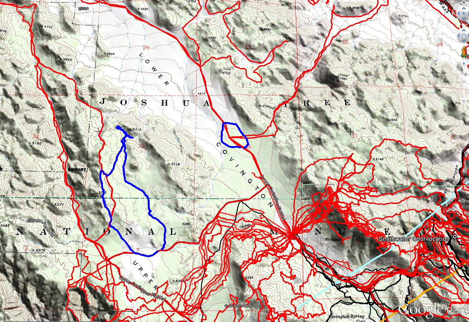
JT78 GPS tracks are shown in dark blue. Tracks from the original search are shown in black and searches since then are shown in red. The light blue line is the 10.6 mile radius from the Serin Drive cell tower and the orange line is the 11.1 mile radius.

Spot the lizard and win an empty water bottle.

Typical terrain in the area.