Writeup and pictures by Adam Marsland
Date: May 28, 2015
Participant: Adam Marsland
General Search Areas: Southeasterly of Eureka Peak; mountain ridge and low areas where Smith Water Canyon meets Lower Covington Flat.
Rationale for Search:
Eliminating small unsearched areas on northerly track from possible cell ping site in Upper Covington, and on 10.6 mile line adjacent to Lower Covington Flat.
Impressions of Area and Findings:
Terrain southeasterly of Eureka Peak is easy and scenic; terrain of bluff overlooking Lower Covington Flat is steep and rocky.
Coverage Level:
Excellent near Eureka Peak, good in flat areas adjoining Smith Water. As for the steep ridges near Lower Covington…Bill was never here. Trust me.
Comments:
I want to emphasize that what follow are my own — Adam Marsland’s — personal thoughts, and should not be confused with Tom’s.
After having formulated, tested and rejected a number of theories about Bill’s disappearance, I’ve narrowed probabilities down to my own conclusion about Bill that I think fits the facts and satisfies me. That said, I can’t prove it (nor is proving it important to me), and parts of it might strike some as a little off the wall, so it’s probably best to continue to keep my own mind open and not influence other peoples’ conclusions with my own. Suffice it to say that while I think the cell ping’s timing and location are significant, I don’t think it means what it seems to mean…and I no longer believe Bill’s remains are to be found in JTNP.
Having said that, what Tom has done with his search, the collating of data, and crowdsourcing the information is revolutionary, and the “master map” model could conceivably be used in other missing persons cases where there’s a set area to cover and there’s no longer an active search effort…the disappearances of Bryce Laspisa and Brandon Swanson leap to mind. Given that more and more people are becoming “websleuths,” I believe that interest in Bill Ewasko will only grow with time. Even if I don’t personally think Bill is here, I’ve come to know the case and the topography pretty well and I have no problem contributing to the search from time to time. And I could always be wrong and I or someone else might find Bill yet, in which case it’s a useful thing to do. Provided I can think of a worthwhile place to look, which is becoming difficult.
On that note, it’s something of a tradition to go look for Bill after I come home from tour, so I made my way out a few days after a long Europe trip. On my last visit I realized there was still a small area on the northern edge of Upper Covington Flat south of Eureka Peak Road that no one had looked at. The rationale is that if Bill’s phone pinged Serin Tower on the west edge of Upper Covington (and I think it did), assuming Bill was there lost, it makes sense he would have continued north along the ridgelines towards the road, which he should have sighted in the distance upon entering Upper Covington.
I’d never before made the right turn to Eureka Peak – after so many unproductive trips to Upper Covington it was strangely liberating – and the view there was beautiful. I was shocked to encounter actual people there; I’d never seen anybody on any trip to this neck of the woods. Walking south from the road, the search area was quickly reduced upon discovering a very obvious and well traveled trail bisecting it. Really, it was simply a matter of following the ridgeline south (the ridgeline is significantly cooler than the ground below, so it’s a safe assumption a dehydrated/heatstroked hiker would stick to it) until the terrain began to look depressingly familiar, then backtracking northeast towards the road, also a fairly clear-cut path, hopefully staying clear of Tom’s previous trips through this area. From this vantage point I could command a magnificently clear view of the huge canyon that I once theorized was Bill’s escape route. It looked even more wide and inviting than before — and the descents even more hellish. I noted one of the ridgelines Tom took down to investigate this area and shuddered. A braver man than me.

View of the deep canyon that empties from Upper Covington towards Sky Valley. A plausible exit route for Bill — if there was a safe way to get to it.
Upon returning to Eureka Peak, I then walked to the overlook just north of there. Had Bill made it this far, he certainly would have gone this extra step to assess his situation — and found out that he was still very, very far from civilization. Two well marked trails lead in the direction of Yucca Valley from here and future searchers might be interested in having a look along them in case Bill decided to walk out. My opinion is that he would have stayed put at that point. Trail or no trail, it would obviously have been a waterless, shadeless bridge too far.

View north from Eureka Peak. If Bill had made it this far, this is what he would have faced trying to walk out.
I had plenty of time left, but my GPS seemed wonky, so I made a quick trip back to Yucca Valley to cool off (it was 91 degrees out — with the wind and time of the year, actually not too bad, but still darned hot) and to make sure my tracks uploaded. Accomplishing that, I was ready to go back, but ran into the same problem Tom has lately run into – where to look. I could think of a few spots that had not been covered, but they were all in areas I had already looked at, was skeptical of, and did not have any great desire to visit again. I did debate continuing to look alongside the road to Lower Covington as some have suggested, but the more I think about it, given the timing of the ping and the presence of rangers in the vicinity shortly thereafter I don’t see how Bill would not have been observed trying to walk out. Finally I decided to head back to Lower Covington and check out some old mine remnants I had seen on the topo map and had always wanted to look at.
Someone had once suggested this spot be searched on the idea that Bill might have headed for these prospect holes to get shelter while he was waiting for help. I can categorically state that this did NOT happen. The climb up to the area is steep, loose, and brutal, not to mention extremely hot – and the approaches nearby were even worse. It was an extremely interesting journey though, with the remnants of an old tramway and a stone causeway built into the rock that I had first observed on googlemaps. I’m a history buff and would love to know more about this spot.
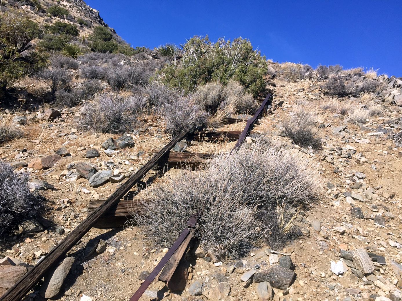
Ruins of old mine tramway near Lower Covington.
The causeway petered out into a barely discernible path that traversed the rocky and steep north face of the mouth of Smith Water. I made my way down at the first spot where it looked possible to do so without crawling or falling. This put me in the general area of the only part of the 10.6 mile radial line that runs north of Smith Water. I had been up to the higher ground on this line on an earlier search, so I walked along it in this lower lying area as best as I could reckon just to be thorough. At no point was there even a hint of cell reception.
By this juncture I’d had a good part of the day in the sun and I was pretty beat. One of the hardest things to comprehend about Bill’s disappearance is that if he was lost in JTNP for 2 1/2 days, how he could then travel so far from the ping site that we can’t find him. I’m younger than Bill and quite used to the heat, but just after one day in the summer sun even getting back to the car was a struggle.
That said, it was a lovely day in Joshua Tree…probably my last one for awhile. But I’m grateful I was able to go and enjoy myself and contribute to the search.
GPS Mileage For This Trip: 6.4 miles
Cumulative GPS mileage to date: 866.1 miles
GPS tracks for this trip in Google Earth kml format
GPS tracks for this trip in Garmin gdb format
GPS tracks for this trip in gpx format

JT79 GPS tracks are shown in dark blue at the left and right. Tracks from the original search are shown in black and searches since then are shown in red. The light blue line is the 10.6 mile radius from the Serin Drive cell tower and the orange line is the 11.1 mile radius.

Unusually intact animal skeleton.