Date: May 11, 2016
Participant: Tom Mahood
General Search Area: Side slopes of Smith Water Canyon between the easterly Acacia grove and its mouth
Rationale for Search:
See Ewasko Thoughts, May 2016. It’s all there in way too much detail.
Impressions of Area and Findings:
A rather small area to investigate, but areas of very vertical terrain. And the hike to get into this area just sorta sucks.
Coverage level:
This was mostly an investigative trip to consider the “Bill climbed back up after reaching Smith Water’s bottom” hypothesis so serious searching wasn’t performed. But I was able to scan and clear some potentially promising southerly slopes via binocular from the northerly side.
Comments:
I truly hate poking into this area. Not because of terrain treacherousness, of which there is some, but mainly due to the damn slog across the valley, past Samuelson’s Rocks, to get there. I’ve done it enough to loathe it, especially on hot days, which this was. And it’s uphill on the return to the vehicle, which is visible from a looong way off. Tedious!
My main goal for this trip was to be at the edge of the easterly Acacia grove in Smith Water’s bottom, look easterly down canyon, and see if the topography might have inclined Bill to climb up the unsearched northerly slopes in a possible attempt to acquire a cell phone signal. This didn’t work out quite the way I planned for a couple of reasons.
First, just as I was approaching (what I thought was) the easterly Acacia grove, I heard a beep from my GPS and found it had shut down. Trying a restart showed it to be dead. Despite a fresh charge in my batteries, it appeared my GPS rechargeable batteries finally decided to die. So for my tracks from that point on, I had to recreate them in Google Earth as best I could. It also put a damper on any serious searching as I wouldn’t have a record of what ground I had covered.
The second problem was that while I thought I had reached the Acacia grove, I in fact hadn’t. Turns out there’s a small “faux grove” just east of my main destination. From my downstream perspective it looked about right (I hate these things so I wasn’t about to poke into them!) so I turned it around at that point a bit prematurely and went up the northerly slopes for a while.
I have to say I was a bit disappointed. I was looking for a compelling reason that Bill might have decided to climb the unsearched northerly slopes and really didn’t see one. Were it me in that position, I’d be drawn toward attempting the southerly slopes for a couple of reasons.
First is that the southerly slopes have a sense of a visual “top” to them. There is a small, but very pronounced and apparently attainable peak as part of the southerly slope. Were I wanting to get to high ground to either signal rescuers or acquire cell coverage I’d probably want to head there (When I make these judgments I try to set aside my hard-earned knowledge of the terrain and cell coverage patterns). By contrast, the northerly slopes are steep and just seem to rise up out of sight.
Secondly, the southerly slopes due to their northfacingness, tend to offer more shade among the outcroppings. It just looks like a more pleasant climb. For someone out of water that might be a significant attractor.
So the northerly slopes I was on didn’t “feel” quite right and I spent a lot of time scanning the southerly slopes with binoculars. I had an excellent view and think I was able to visually clear the slopes of the aforementioned southerly peak from its top all the way to the bottom of Smith Water.
I should mention there’s a subtle difference in expected lost person behavior between assuming succumbing on a descent versus an ascent, and likely affected our previous southerly slope searches. When searching on descent and reaching a “cliff out” (a steep rock face resulting in a cliff) we would typically divert right or left around the cliff and continue descending. Since people seldom continue straight ahead off cliffs, we would be less inclined to examine the very bottom of the cliffs very closely.
However for someone ascending a slope a cliff face poses a substantial barrier to their ascent, especially if physically compromised. So in a “climbing up from the bottom” scenario, the bases of cliffs, and otherwise passed over chutes, take on increased importance.
Because of my failure of actually examining the terrain as viewed from the easterly Acacia grove I can’t yet say with any confidence the northerly slopes of Smith Water should be discounted. I’ll fix that on another trip. I had lowered the probability of Bill being on the southerly slopes due the extensive searching which has occurred there over time. But there is a patch of very good cell coverage on the southerly slopes, just above some rather substantial cliffs, which are probably worth a revisit.
I did return with an important constraint for the “climbing up from the bottom” scenario. For this scenario to be valid it assumes initial searchers entering Smith Water failed to notice any tracks Bill might have left possibly crawling along the bottom of Smith Water. The area I assume Bill reached the bottom of Smith Water at is a mixture of very loose sand and rocks. Over the possibly four (!!) days between when Bill would have left tracks and the searchers first arrival tracks could have been degraded into unrecognizability due to weather and animal traffic. However about 0.4 miles easterly of the east Acacia grove the wash bottom flattens and widens considerably and winter rains leave it smooth and hard packed like cement. I observed my tracks clearly and they were a major disturbance that would remain for some time. Had Bill reached this far easterly in the canyon bottom, he would have left tracks, crawling or not, that would have been quickly spotted by searchers. So I’m inclined to at this point rule out slopes on either side of Smith Water from its mouth to about 0.5 miles in (southwesterly).
GPS Mileage for this trip: 7.5 miles.
Cumulative GPS mileage to date: 894.8 miles
GPS tracks for this trip in Google Earth kml format
GPS tracks for this trip in Garmin gdb format
GPS tracks for this trip in gpx format
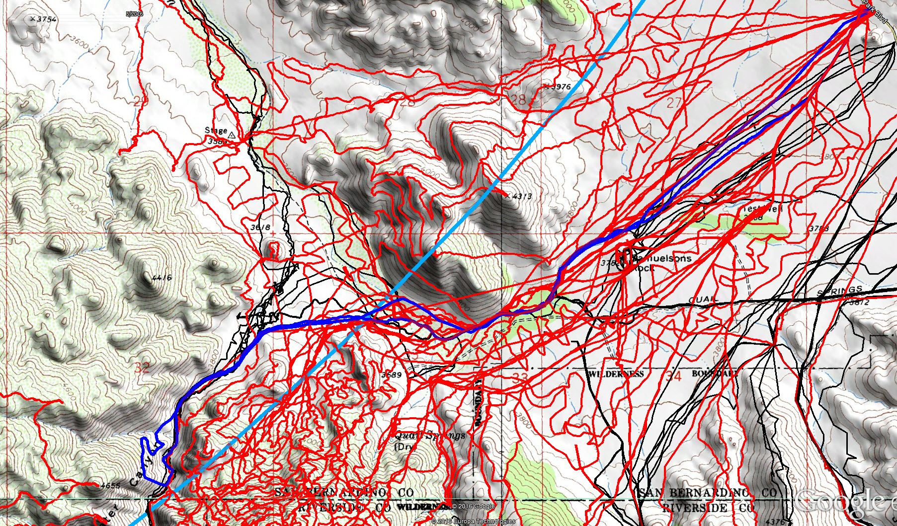
JT83 GPS tracks are shown in dark blue. Tracks from the original search are shown in black and searches since then are shown in red. The light blue line is the 10.6 mile radius from the Serin Drive cell tower.

Looking easterly down canyon from the edge of the faux Acacia grove. That hill on the southerly slopes appears a desirable target should Bill be looking to gain a high spot. It has, however, had considerable search coverage.

A panorama showing the southern slopes of Smith Water viewed from higher on the northerly slopes. The peak of interest mentioned is just left of center and marks the 10.6 mile radius. The upper areas of the peak to the right receive excellent cell coverage from the Serin Tower however significant searching has occurred in that area.
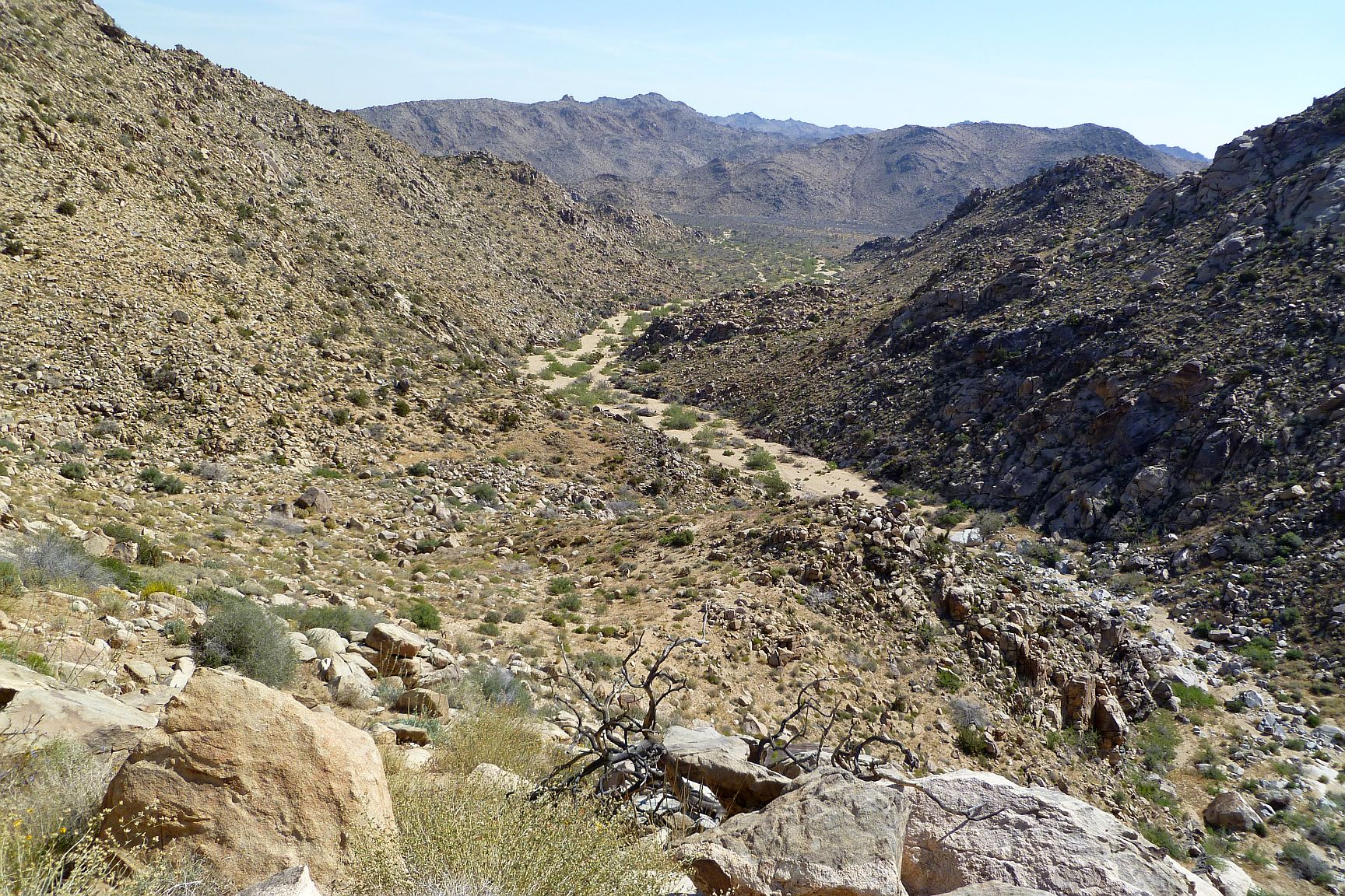
Looking easterly towards the mouth of Smith Water Canyon from up on the northerly slope. Note the widening of the wash in mid-picture. This is the beginning of the hard packed sand bottom of Smith Water and renders tracks very visible. It seems unlikely Bill could have continued beyond here without searchers spotting his tracks.
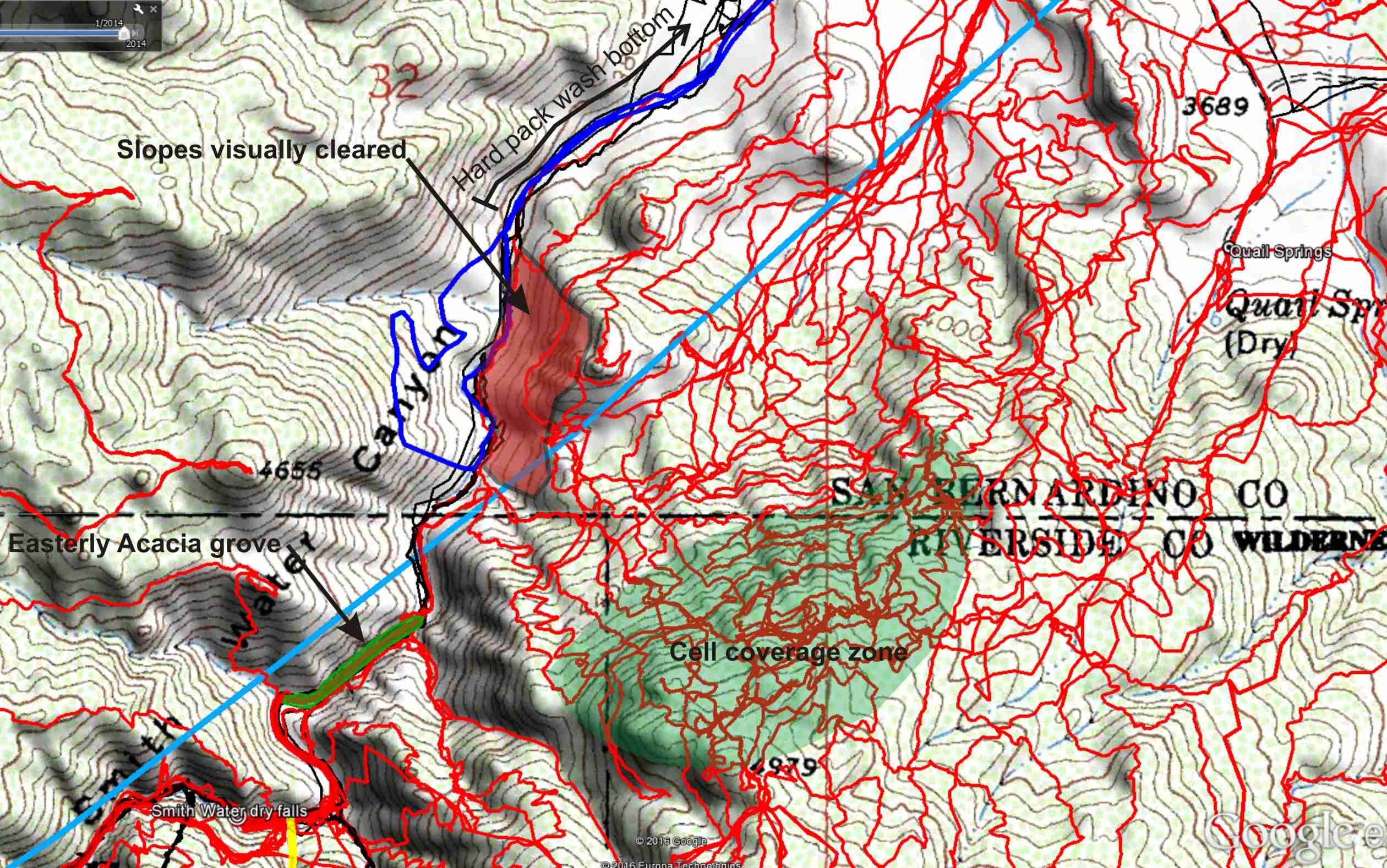
A closer look at areas covered by JT83. I believe I was able to visually clear the red shaded area by binocular examination from the opposite slope. Note the designation of the hard packed area of Smith Water’s bottom, beyond which I think it’s unlikely Bill would have traveled without leaving distinct tracks.

Yet another deer or Bighorn skeleton. Clearly my stuff finding skills are still operating, I’m just not finding the right stuff.
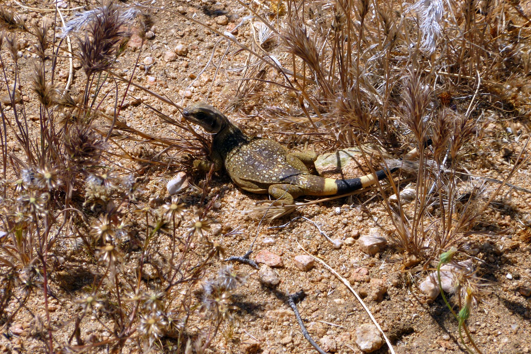
A rare sighting (for me) of a Chuckwalla lizard. Any trip I see one of these guys instead of a snake is a great trip.