Date: May 12, 2016
Writeup by Adam Marsland
Participant: Adam Marsland
General Search Area: Rocky areas at the foot of mountains to the west of Quail Wash and north of Smith Water Canyon
Rationale for Search: These are unsearched areas near a plausible exit route for Bill, assuming his phone pinged in Quail Wash.
Impressions of Area and Findings: Easy terrain, lots of places that offer shelter, watch out for cholla.
Coverage Level: In terms of likely shelter areas formed by rocks at lower levels, very good. Spotty elsewhere.
Comments:
There’s a guy on websleuths whose signature line reads “never assume you know anything or everything about a missing person.” It’s probably the most useful thing written on that whole site, and it’s part of the reason I’ve continued to search for Bill even though I came to the conclusion a while ago that he’s probably not here…because that conclusion was based on the facts of the case as I know them, and if the facts change, so would my opinion.
There’s been a lot of movement in the case the last few weeks in terms of new or changed information, and after last week’s look around the wide bowl valley around Quail Wash north of Smith Water Canyon, which offered the first plausible place to look (to me) in a long time, I was curious to return. Quail Wash is the one reliable coverage area (or so I thought – more on that below) at 10.6 miles from Serin, and it lies at a logical topographical waypoint if Bill descended from Quail Mountain and tried to walk out.
One of the big reasons I did not take Quail Wash seriously as the site of Bill’s ping was my understanding was that there were searchers near the area only a few hours afterwards. I thought Bill would have had to move quickly away from there to avoid being found. After a conversation with Tom this week I discovered that this was not correct. There were searchers nearby that day (though not at that spot), but they were on their way out of the search area at the end of the day…many hours after the ping. That means Bill could have plausibly been in Quail Wash Sunday morning and not encountered anybody. This changed an awful lot from my perspective.
If Bill had been at that point in Quail Wash, he would have had three options: west up Smith Water Canyon to possible water, right towards Park Road, or straight ahead to Joshua Tree Village. The last would seem to be the least attractive option, except for one thing – it would have been the easiest route of travel, and if Bill was injured, going up the wash might have seemed the best move. Only problem is, if Bill expired anywhere around Quail Wash, one would expect him to have been found. Searchers and others have crossed over the Quail Wash/Smith Water Canyon junction area many times, and the Quail Wash area further north near the Joshua Tree National Park boundary is well traveled by locals. The area in between is less traversed, however, and there are many rocky spots on either side that might be attractive to someone in Bill’s situation seeking shade and shelter. I was anxious to get back to this area and look at some of these areas on the west side of the wash which had never been searched.
Unlike one week ago, when I arrived it was pretty hot, which was good in terms of assessing probabilities for Bill’s route of travel (though less comfortable to be out in). Parking my car the same place as last week, I rapidly made my way south two miles into my primary search area. I then headed towards one large knoll, and thence to the foothills of the mountains that on the other side form the north face of Smith Water Canyon. I’m grateful, at least, for this new and pleasant entry point to the area. I share Tom’s absolute distaste for the slog down and back from Park Road past Samuelson’s Rocks.
This was the first time since Upper Covington that I thought I might really find Bill. It all did line up and make sense, and looking over these rocky areas, there were quite a few of them that would offer shelter to a lost hiker resting and shading himself. I looked through every one I could find in this area, and found nothing other than some animal scat and a particularly nasty cluster of cholla which embedded itself into my boots.
After a couple of hot hours I began to lap the previous week’s search and then headed overland southward towards the area – not visited for some time – where Quail Wash meets Smith Water Canyon, checking out a few more spots on the way. I wanted to register the solid coverage area at 10.6 I had noted on previous trips out. To my surprise, when I arrived in that area, this time I was not able to connect. This indicated the coverage in that spot was not as reliable as I had thought – which ruled out another objection to it having been the source of Bill’s phone ping (since to my thinking if his phone had connected there, he should have just been able to call for help).
With night falling, I made my way back up through the Quail Wash area, noting an old mine dump, reception becoming more reliable as I traveled further north, and trying to poke through more rocky areas on the east side in the rapidly gathering dark. Tom had been there before but these areas are probably worth a closer look. I finally made it back to my car around 9 p.m., quite frustrated at a long and fruitless day and more so because my favorite restaurants – and the sources of my post-search reward food – were all closed.
After this week, Quail Wash has to me jumped to far and away the most likely source of Bill’s ping, with a few of my main objections now being swept away with the new info (though even so I am not totally certain that something hinky did not in fact occur here). In fact, in terms of likely reception and topography, it’s just about the only place that makes any sense at all – but as usual, he was not to be found in any of the places that were the next logical possibilities based on that theory. And then, when I got to Joshua Tree Saloon, I noted the following comment on the youtube video from last week’s search, from Reddit poster Chris Potter:
“A handshake is a very low power action…what if the phone’s ability to handshake/ping did not necessarily mean there was enough signal to get a call out? Searching Google, I found a lot of articles (many on survival tips websites) that mention this, like this right here: “Unlike voice calls or text messages, these electronic packets require very little energy to send or receive. Sometimes these handshakes transmit when your phone indicates no reception. Sometimes they bounce off towers that your phone doesn’t have permission to use. And sometimes they get through when they shouldn’t–like in remote and mountainous terrain.”
If that’s the case, then my focus on identifying ping sites is perhaps not all that relevant. However, in the bigger picture, it probably doesn’t change much. If you take cell receptivity completely out of the picture, there just aren’t that many places that make any sense at all along the 10.6 mile radial line. Tom’s new theory about the acacia grove in Smith Water makes as much sense as any, but I do have a problem imagining Bill then going up the north face (I think Tom might as well) – it just might have been too much to attempt. Topographically, and also for cell receptivity, Quail Wash makes a lot more sense, and unlike the other spots, he might have traveled a considerable distance onward from there and not been found. But the question then remains, if Bill did ping in Quail Wash, where did he go next???
Youtube of this search is here:
https://youtu.be/pelNJ6p_194
GPS Mileage for this trip: 12.5 miles
Cumulative GPS mileage to date: 907.3 miles
GPS tracks for this trip in Google Earth kml format
GPS tracks for this trip in Garmin gdb format
GPS tracks for this trip in gpx format
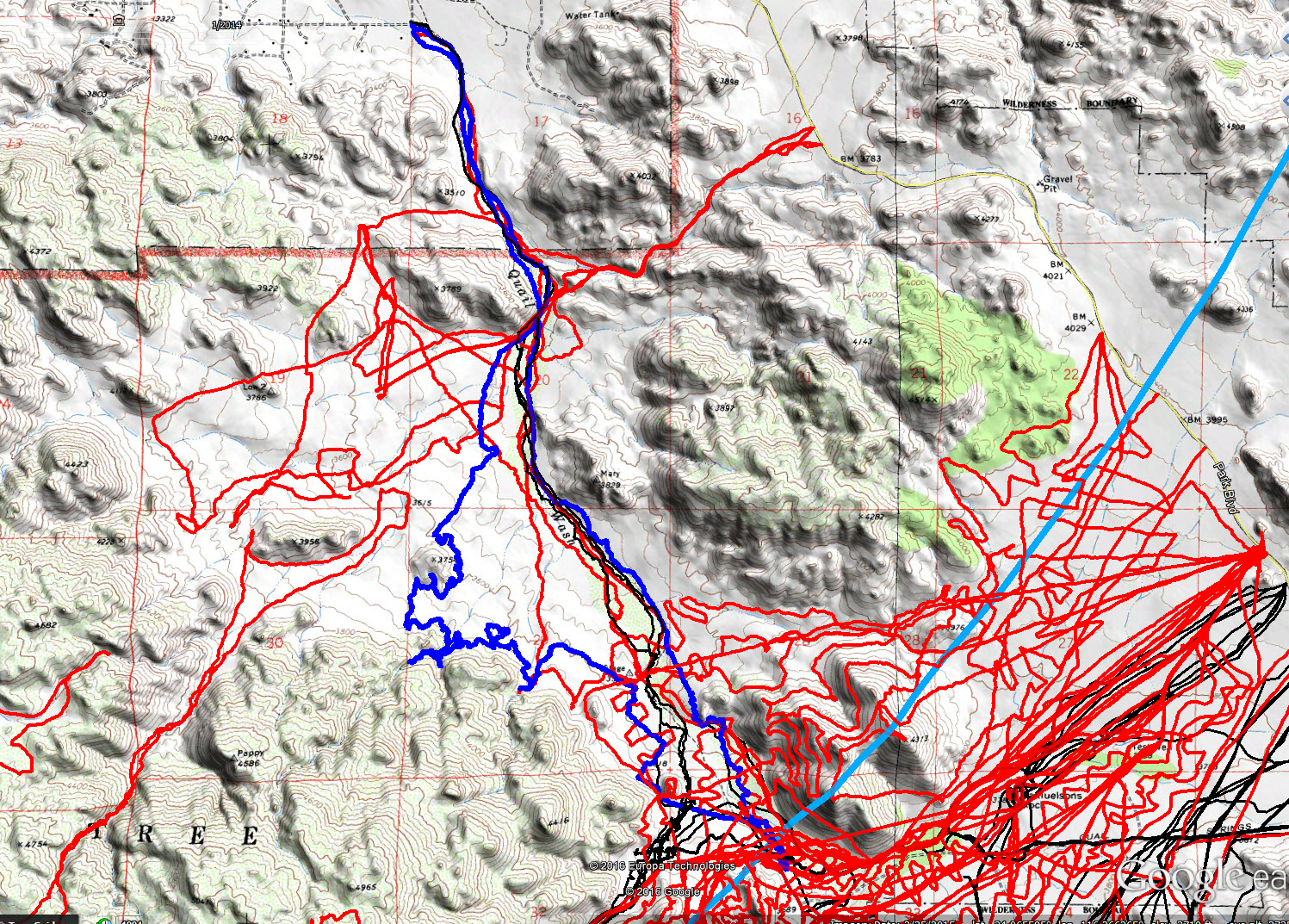
JT84 GPS tracks are shown in dark blue. Tracks from the original search are shown in black and searches since then are shown in red. The light blue line is the 10.6 mile radius from the Serin Drive cell tower.