(Look, let me warn you up front there is way too much text in this and few pics. If you value your time at all, leave now and do something more interesting like watching funny cats on the internet. If you have no life or your escape key doesn’t work, than by all means read on. But I warned you, ‘cause that’s the sorta guy I am.)
As the four or five regular readers of this bloggy thing may have noticed, I am prone to go down assorted rabbit holes with my interests. Rather than Jeri’s view of this as being tiring at best and annoying at worst, I choose to simply embrace it as part of my charm. And my latest little, um…. interest is contributing to a government program called GPS on Benchmarks.
I’ve been working on a few recreational mapping projects lately, and a side effect has been upping my GPS game. Unfortunately as expensive as consumer GPS units can be, they by design lack the accuracy to do any sort of detailed mapping. To do that you need a mapping grade (better) or survey grade (best) GPS receiver. However those suckers are stupidly expensive….sorta.
It used to be that the US had the monopoly on satellite navigation systems with our Global Positioning System (GPS). No longer. The Russians have implemented a similar system called GLONASS, the Europeans have Galileo, and the Chinese are starting their BeiDou system. As a result, manufacturers of survey and mapping grade GNSS receivers (the correct designation for satellite location systems) are now selling units that receive ALL satellites, not just the USA’s GPS system. Since most surveyors want the latest and greatest equipment, they have been offloading their older GPS-only units at a tiny fraction of what they originally sold for. And I loves me a bargain.
In the world of recreational and consumer GPS Garmin is sorta king. I’ve had various models of Garmins for many years, and while I found their interfaces annoying, at least it was annoyingly familiar. But in the professional survey and mapping world, the crown is held by a firm called Trimble.
So why, when I’m supposed to be writing about a program called GPS on Benchmarks, am I digressing into a discussion about who makes what? (Beyond my usual tendency to ramble). Well, it’s because for a non-professional, Trimble stuff is damn hard to figure out and operate. I mean, it makes Garmin stuff seem warm and fuzzy. Add to that the fact that Trimble pretty much locks down their hardware so that you have to use their damn pricy software with their hardware. It makes Apple look like amateurs. And……wait for it……it was while Googling like crazy to find an end run around Trimble to get some use out of my new, used mapping handheld (Spoiler, there ain’t one), that’s when I stumbled across the GPS on Benchmarks program. Says me….”Wait…..what??”
So with that tedious bit of foreplay out of the way, I’ll move on to some more. Yeah, this could be a long piece. So, just what the hell are benchmarks?
If you’ve been hiking at all you’ve seen benchmarks on quite a few mountain peaks and perhaps some other areas where you’ve wondered why they were there. These marks, usually some variation of a brass disk set in the ground, are used by surveyors to designate a specific spot in space. This is what excites surveyors.
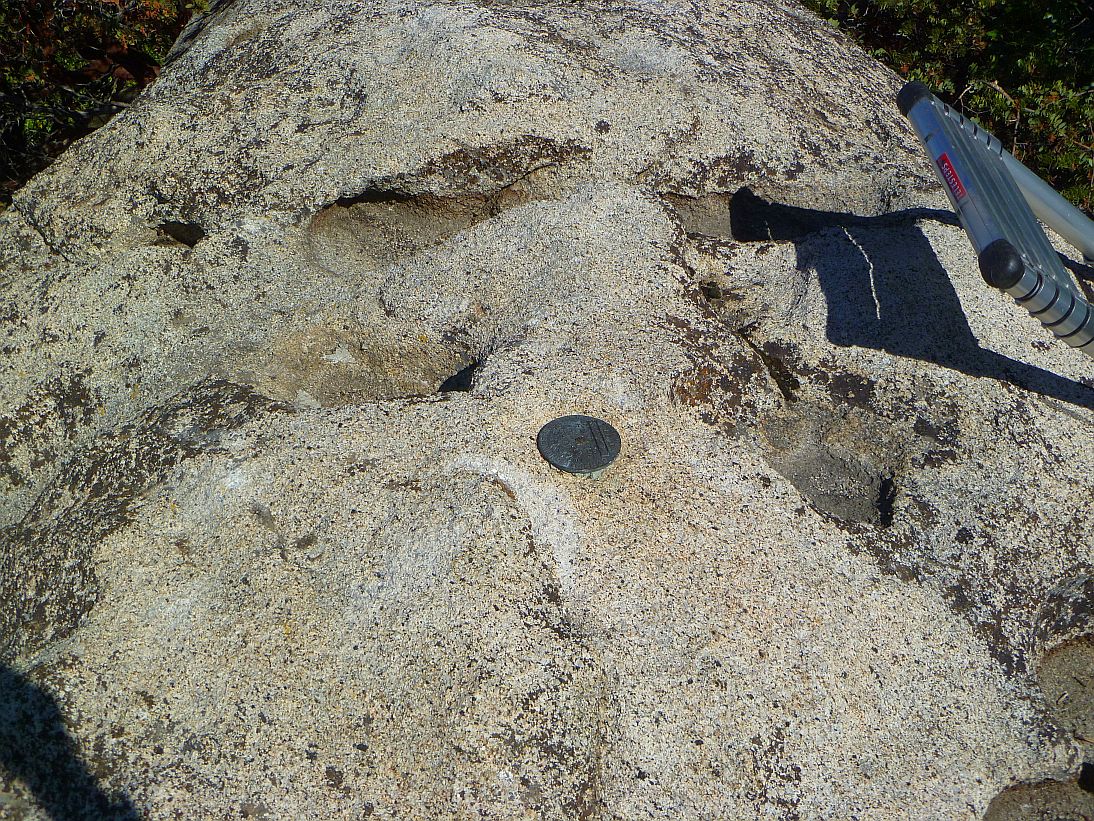
A typical benchmark cemented into the top of a boulder.
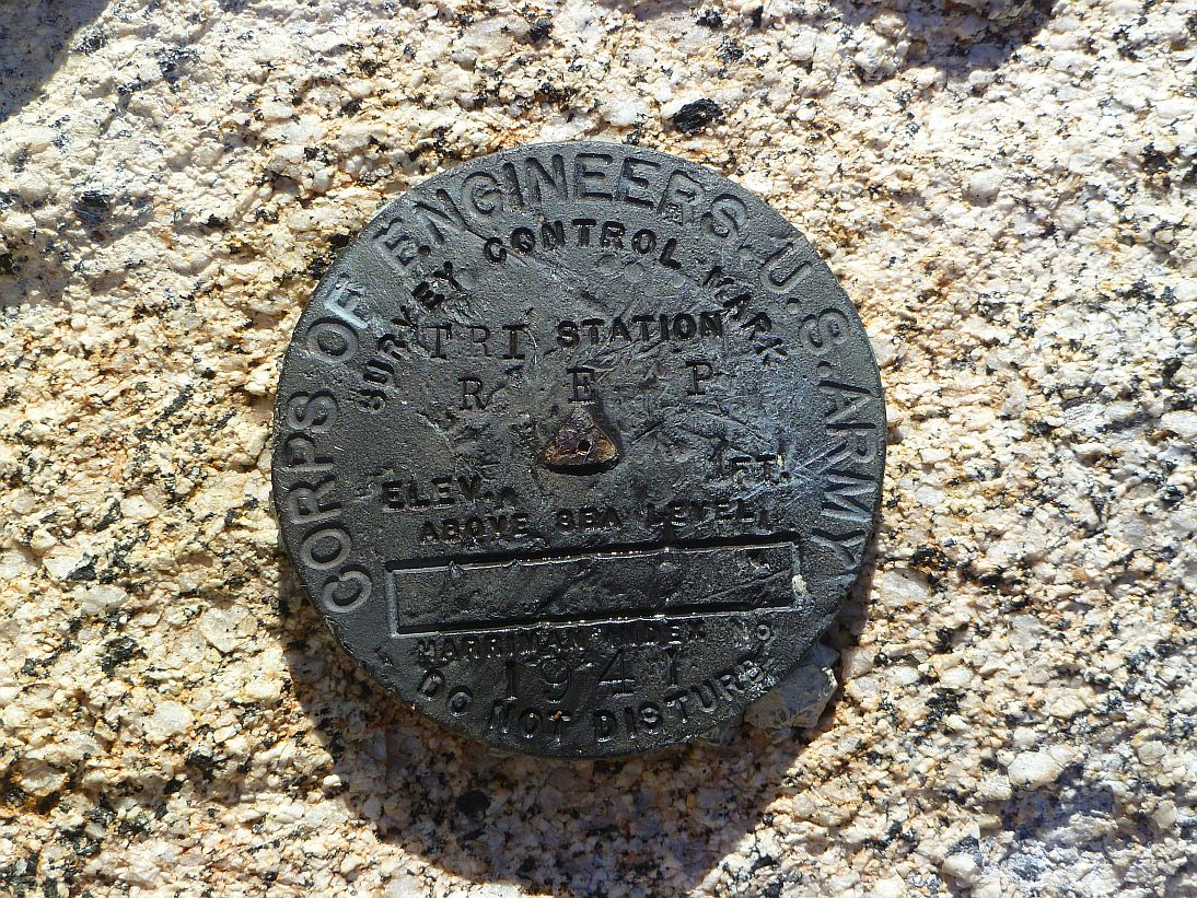
A typical benchmark, in this case a triangulation station.
While there are a number of different kinds of benchmarks, I’m going to lump them into only two categories for the purpose of this piece, those of triangulation and leveling. That sound you hear is the gnashing of the surveying profession’s collective teeth over my arbitrary division.
Most benchmarks found on mountain peaks are actually triangulation marks, properly known as triangulation stations. Surveyors, by sighting on other known peaks with similar triangulation marks, can fix a location horizontally in space quite accurately. Vertically is more of a challenge since, you know, the Earth curves, but the results can be close if you know the heights of the locations you’re sighting at. So somehow, someway, some poor soul is going to have to figure heights, which brings us to the second type of benchmark, leveling stations. (Actually the term benchmark is properly defined as a measurement of vertical height, but all us normal people usually call anything we see on a peak a benchmark. Shows what we know.)
Since leveling stations are a little weird, let me pose a question….how do you figure how high Denver is above sea level? Well in the eighteen and nineteen hundreds a bunch of poor schmuck surveyors started at some average sea level location, say the shores of the Gulf of Mexico, and inched their way to Denver a few hundred feet at a level sighting. Some guy would stand at the edge of the water at the gulf with a survey rod, and the guy using the level instrument (the smart guy) would read a height. The rod guy would then go to the other side of the instrument guy, toward Denver, and the instrument guy would get a new reading. The difference in readings was the change in elevation between these first two points. Wash, rinse and repeat until Denver. Over a great deal of time the entire country was crisscrossed in this manner, which is how we know how high things are above sea level. And once heights were accurately known, the triangulation guys on peaks could tie it all together. I doubt anyone has ever presented a more fractured or screwed up history of surveying in the USA, so….you’re welcome.
A couple things to know about these leveling runs, which will have some importance when (eventually!) discussing the GPS on Benchmarks program. First, the difference from one leveling station to the next was limited to the height of the survey rod. This meant leveling runs usually followed gradual terrain, like railroads and roads. It was the scenic route to Denver.
Second, while the surveyors could measure the change in elevation to insanely high levels of accuracy, they didn’t care much about where they were horizontally. That wasn’t their point. But they marked the locations of their leveling locations on maps the best they could and moved on. And by the time they got to Denver they damn well knew how high it was above sea level.
So over many years, we ended up with around 430,000 benchmarks scattered across the US. And guess what, we don’t know precisely where they all are. About 200,000 haven’t been checked in 30 years and may not even still exist. They could have been damaged by floods or covered by mud or soil.
And the leveling benchmarks, boy they are even sketchier. When the National Geodetic Survey (NGS) created a database of all the country’s benchmarks in the 1970s, they hired contractors to digitize all their paper map data. The accuracy required was that the location had to be scaled off the maps to within six arc seconds, which sounds sorta accurate but actually works out to be around 600 feet. If you’re looking for a benchmark in a brushy or wooded area, you might be looking a while. Feeling lucky, punk?
“So what”, you ask. “That wasn’t even interesting. Why should I care about any of this?” I sympathize with you on the first part, however the latter comes down to three letters: GPS.
GPS uses time signals from a constellation of orbiting satellites to derive a point above the center of mass of the Earth (or magic, I’m not sure). It has no frigging idea where sea level is, it just tells you how high you are above that center point of the planet. And guess what, the Earth isn’t round. It’s sort squashed at the poles and bulgy at the equator and other weird lumps here and there. Sea level is sorta a fluid thing.
So then how does your trusty Garmin tell you your height above sea level when standing on a peak? Something called a geoid model. GPS units have a simplified model of the entire Earth’s lumpiness in them so that when they figure out a position on the planet’s surface they can look up how lumpy the Earth is at that point and calculate a height above what sorta, kinda would be sea level. So it’s important to have a good geoid model.
The Feds think so too. To that end, they are using our tax dollars to generate a new, more accurate geoid model by 2022. And it’s a big damn deal. They are taking benchmark measurements from all over the US, throwing them in to a computer and out will come a shiny new lumpoid….I mean geoid for the country.
But here’s the rub. The Feds can only produce a model that’s as accurate as the data generating it. Garbage in, garbage out. So all these leveling station benchmarks (if they even still exist) while likely very accurate vertically, may be as much as 600 feet off horizontally. That’s terrible for the level of precision wanted in the new geoid model.
Enter some clever individual at the NGS. They thought, “Hey, all these people are running around these days with GPS units accurate to within 20 to 30 feet. That’s way better than our current 600 feet off our old-school maps accuracy. Maybe we can think of a way to sucker them in to help us!”
Enter, at god-damned last, GPS on Benchmarks.
The program allows ordinary folks with Garmins or even GPS enabled phones to report the locations of benchmarks which the NGS can incorporate into their upcoming model. And not just GPS data, they also want pictures to show the condition of the benchmarks. They would be thrilled to know if their benchmarks are still there and that you care about them.
Yeah, yeah, it’s geeky beyond belief. But it’s a good excuse to hunt stuff down in the middle of nowhere (or even down your street if you’re not feeling adventurous) with a socially redemptive purpose. I do enough stupid things that aren’t useful, so this is a refreshing change.
The NGS has a nice web page on the program, which may be found here. I’ve wasted enough of your time so far so I won’t rehash it all (you’re welcome!!) other than mentioning a few tips.
First, while you can submit data on a NGS webpage, there is a more powerful way. DSWorld is a downloadable program written under NGS contract that runs on your computer and will automatically submit your data, reports and pictures to the NGS. I will concede there is something of a learning curve to it but it’s worth it. It also helps you to properly label and size any benchmark pictures you submit, as being Feds, the NGS is understandably picky about this stuff.
The NGS has a data explorer tool which can be used to find benchmarks all over the country. That may be found here. Once you find a benchmark, you can click on it and bring up its data sheet (with enough data to choke a horse, here is a typical example). If it hasn’t been visited in a long while, or there aren’t any pictures, then get off your ass and get out there!
There is also another, possibly more interesting benchmark locating tool, found here. This tool shows the benchmarks that the NGS is planning to use in generating their new geoid model in 2022 (which is why I rambled on so much on the topic). And the leveling station runs become pretty obvious.
The colorings show the areas where their data is good (green) and where it’s not so good (red). And they’d really, really like some good measurements in those red areas. Stupidly, this smells like a challenge to me and I’m looking to turn some red and yellow areas green.
Generally, the way you’d work this is first find benchmarks that might be accessible to you and of some interest to you (i.e., trip worthy). Once you picked out a few, download their data sheets and head to the field. The data sheets always have written descriptions as to how to find the benchmarks, which may or may not be accurate. Snipe hunt time. When/if you find the object of your quest, note the benchmark’s condition, take an accurate GPS reading and pictures following the NGS’s arcane guidelines. Submit via DSWorld. If you didn’t do something stupid and hose it up, your additions will be incorporated into the benchmark’s permanent record. In a manner, you will go down in history. A legacy of geekiness.
The three videos listed on the left menu of the main GPS on Benchmarks page will be of great help if you want to mess around with this program. They are a little bit long, but the 2015 video is probably the best in terms of understanding the program.
Now while that is a great program, I’m not known for leaving things well enough alone. There is another program called OPUS-Share in which you submit actual raw GPS survey data to the NGS and if it passes their quality control criteria, becomes the new location of an established benchmark. This is intended for surveyors and not normal folks. But I am anything but normal.
To participate in OPUS-Share a mapping grade GPS unit isn’t good enough (sigh). You need survey-grade GPS equipment (thanks eBay!!), know how to survey (thanks CSULB!!), and take a measurement of at least four hours (thanks me and the patience I don’t have!!). But it’s really, really cool. With halfway decent GPS satellite views I’ve been able to get measurements of well within a centimeter. This, as far as I’m concerned, is scary, voodoo science. But very, very satisfying. Your mileage may vary.
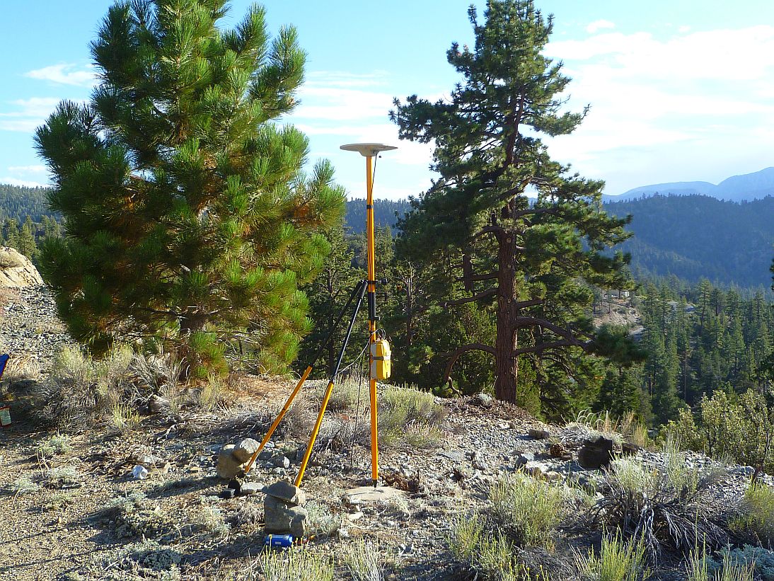
A typical setup for gathering OPUS-Share data. Come back in four hours.
As your reward (?) for making it this far, here is an example of one of the OPUS-Share submissions I did. And, oh why not, here’s another one. Fun, but definitely not for normal folks. Stick with reporting via consumer and cell phone GPSs, along with pics, and it will be easy.