Damn.
I’m getting too old for this shit. Or at the very least I should know better at this point in my life.
Once I started getting into the GPS on Benchmarks program and discovered no surveyor had visited or checked the position of the Antonio benchmark since 1951, I knew I was doomed to do so. I dearly wanted my first visit to the site of Michelson’s Lookout Mountain station to be my last, beyond a visit via drone for pics from a paved road 2 miles away. Not only would I have to haul my sorry ass up to the top, I’d have to bring along a crapload of GPS survey gear, including a tripod that would have to sit on the benchmark for at least four hours.
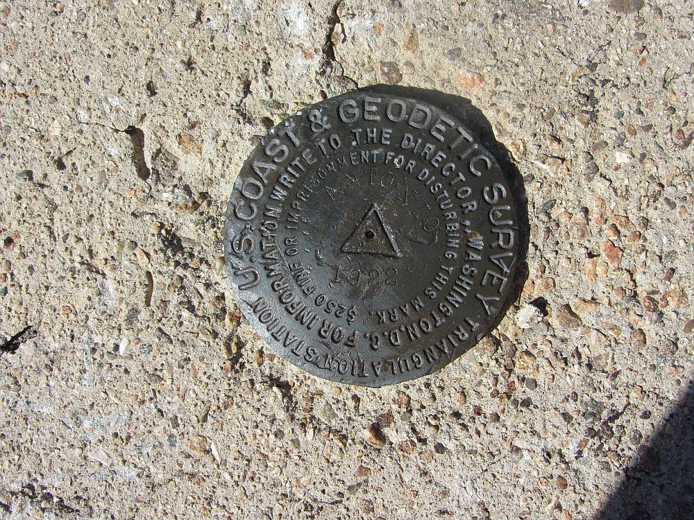
The Antonio benchmark
And that sitting on the benchmark deal was a bit of a problem. I knew from Pease’s original drawings for the facility that the top of the concrete pier the Antonio benchmark was set in was only 16” square. And it was about 3-1/2 feet high. My saucer shaped GPS antenna sits on top of a 2 meter pole, whose bottom point sits in the dimple in the center of the benchmark. The antenna pole is held upright and plumb by an adjustable leg bipod. This meant that with the antenna pole in the center of the pier, on the Antonio benchmark, I’d only be able to spread the bipod legs 11 inches open. And it would have to be stable in the event of wind, and not fall over during the four hour minimum measurement period.

Hmmmm…So just how does one balance a two meter tall GPS on a 16″ square concrete pier? It falling off could be…..expensive.
I made a mockup on my garage floor and found a possible solution. If I took a couple of aluminum “L” channels and cinched them to the top of the concrete pier with webbing, they’d form corners to hold the bipod legs in place. I could then use stuff sacks filled with rocks to weigh down the entire, precarious setup. It just might work. But the planning junk was the easy part. I still had to get it all up there.
I knew from my previous experience there were three routes up to the top of Lookout Mountain and were listed by the Hundred Peaks Section of the Sierra Club. The route I originally took was a steep sucker, but it was a known quantity, with 2,300′ of gain in only 1.9 miles. However there was some hinkiness about it, with it crossing private property on its initial portion that made me uncomfortable. When I did my original trip there was some sort of “permission slip” from the owner that could be printed out online, which I did. However ownership had changed and there didn’t appear to be a way to obtain clear legal permission. Checking with the ranger station in Baldy Village failed to clear up the route’s legal status. Not being the sort that likes to trespass (or at least unburdened enough to be stealthy!), I looked at my other two options.
One, via Bear Flat was easily dismissed for being too many miles (2,800′ gain over 5 miles). I ain’t hiking that far. But there was an interesting middle route that intrigued me. It started the same as the Bear Flat route, from near the Baldy Village ranger station, then left it and ascended up a ravine to join the route I had used previously. At the time I recall seeing what looked like an old trail descending to Baldy Village, which would have been this route. At only 2 miles to the top, with a 2,600′ gain, compared to my original route it shouldn’t be any worse, and perhaps even better. It looked interesting, and well……how hard could it be?

My route up/down Lookout Mountain is shown in red. The route use for my first trip up is shown in violet. The route via Bear Flat is shown in cyan.
Since I wanted to do this only once, and wanted it as accurate as possible, I initially considered doing it as an overnight trip and leaving my GPS rig up and running during the night. This would provide a longer measurement period, thus increasing accuracy. Further, the measurement would be taken when the ionosphere is much quieter, further improving accuracy. However I was very wary of hauling all the gear required to do the GPS measurements as well as normal camping gear. So when I discovered I could get sub-centimeter accuracy with a good satellite sky view and a long enough data gathering period, I ditched the overnight idea. Good thing.
My plan was to get up stupidly early to arrive and park at the Baldy Village ranger station just as it became light. I also needed a time when it wasn’t forecast to be too windy since I wasn’t overly confident in my rig’s stability on the pier. Between that and other stuff going on in my life, October 9, 2017 seemed like the day (Turned out this was one day off from the nine year anniversary of my first trip up Lookout Mountain). I left the truck at the ranger station just as it was getting light, per plan.
The route I chose had three basic components. The first section was along a paved road serving some cabins, then a short distance along the trail to Bear Flat. At a certain point I’d need to leave the trail and ascend a “route” to a saddle where I’d join a small but obvious use trail I had used on my first trip up Lookout Mountain. Pretty easy to understand and follow. And it was only two miles. Yeah….
Despite my heavy load, the part on the trail wasn’t bad and I motored along marveling at the number of cabins tucked away in the canyon. For some reason, I had it in my head my turnoff to the route portion was after I got past the cabins. What can I say…..sometimes the voices I hear are wrong.
It wasn’t until I was disturbingly high on the trail, well past the last of the cabins, that it occurred to me that just maybe, sorta I should have been headed toward that saddle I could see way across on the opposite side of the canyon. Oh shit.
I whipped out my GPS, and sure enough I had blown right past my turnoff which was now some distance below me. Stupid, stupid, stupid. To add injury to insult, I could see the ravine I needed to ascend opposite me, and I had climbed at least half that height already. Which I now needed to descend and climb for reals. I briefly considered continuing on via Bear Flats but I knew there were some off trail portions for that route and I didn’t have the specific info with me. So back down I went.
By the time I got back down and started up the ravine route, I figured I had lost “only” 45 minutes. Not too bad. I should be able to reclimb quickly. Uh, no.
Between the load in my pack, and carrying the pole/bipod sack, this route was a nightmare. My only consolation was that I was following a GPS track that had been posted for the route so I didn’t get stuck in the brush. But the steepness was kicking my ass and since it was now warmer than when I had first departed I was starting to burn into the 3 1/2 liters of water I assumed would be sufficient.
Eventually, I stumbled up on to the saddle where I joined the route I had used on my first Lookout Mountain trip nine years earlier. Now maybe I was fitter then, and definitely carrying less weight, but damn, I don’t remember this use trail as being that steep. There was sorta a trail, and I kept to it as best I could. However I was stopping to rest far more than I should have and was rapidly running out of energy.
Based upon the projected numbers of GPS satellites in view for highest accuracy, my original plan was to start data gathering around 9:20 AM and continue as long as I could but ensuring a return to the truck by sunset, which would be 6:24 PM. Well, I didn’t even reach the site until 11:15 AM, a damn four stinkin’ hours after leaving the truck. Rather than having a leisurely time to do my equipment setup, I raced to get it all up and working and got it going in only about 10 minutes.

It ain’t pretty, but it worked. The stuff sacks contain rocks to weigh the bipod down and help keep it in place without moving in the wind. When you’re measuring down to a few millimeters, you don’t want ANY movement.

Using webbing to hold aluminum angle pieces at the corners provides a retention to ensure the bipod legs don’t go flying.
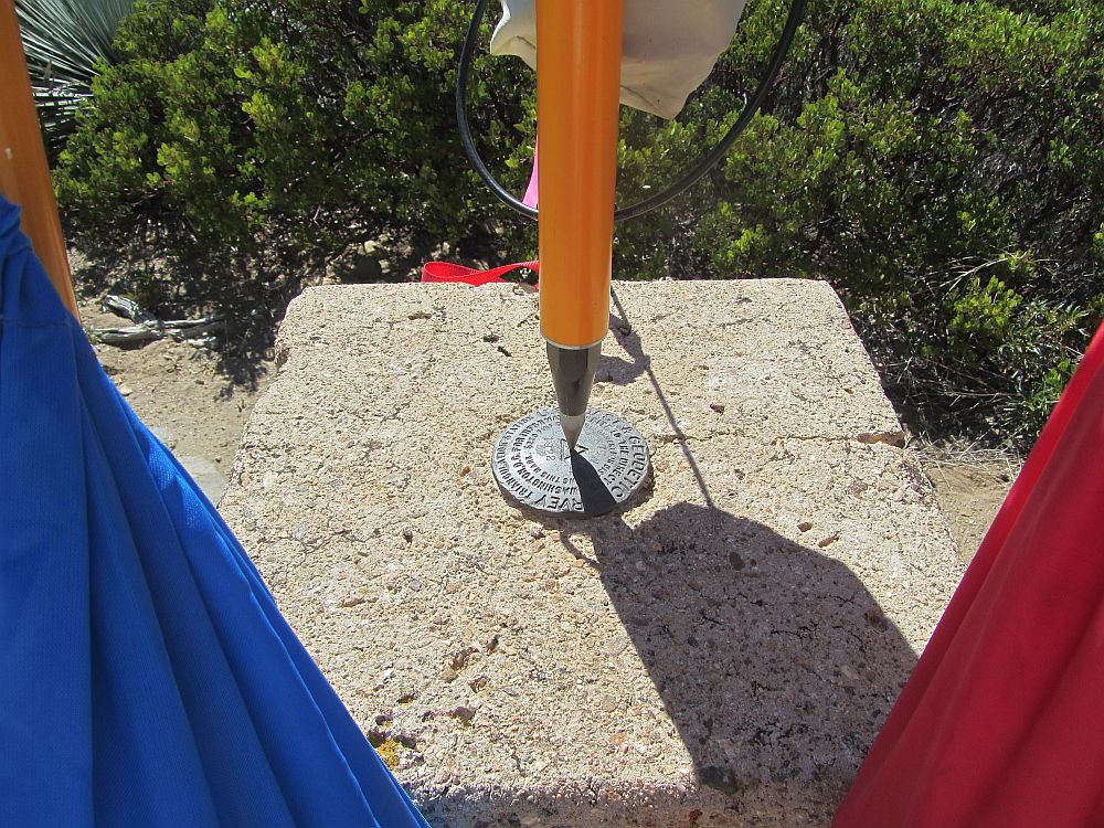
Right in the dimple in the benchmark.
That accomplished, I retreated to the shade of a large bush to take stock of the situation. I knew I needed a minimum of at least four hours of data gathering for submission to the National Geodetic Survey (NGS) and thus enshrine myself into the Antonio benchmark’s data sheet for all eternity. Such is the price of fame. But the longer I left it running beyond that, the more accurate the resulting measurement should be. However I had to be down by dark, and there was the little matter of the amount of water I had burned through. It was comfortable in the shade, but I decided to wear long pants and a long sleeved shirt for protection which increased my perspiration and water burn rate.
My one luxury was a lightweight REI folding chair so I sat in the shade and did the math. I could see Baldy Village below me and it seemed deceptively close (this is how people get into trouble). I felt 4:30 PM was a reasonable “must leave by” time to reach the truck by sunset. I was troubled by the unexpected level to which I was exhausted, which probably would have been eased had I gulped down the bulk of my water. Which I couldn’t. I decided to ration my water while I kept quiet, reading under a tree, leaving one liter for the start of my descent. Granted I was the only one requiring I be there, and I could leave at any time, and it was only about two stinkin’ miles back to my truck, but for the first time in recent memory things felt a little sketchy and vulnerable. Did not like. It’s a series of mistakes and bad decisions like these that get people into trouble, and I should know that better than most. Or maybe it was just me knowing that generated my misgivings.

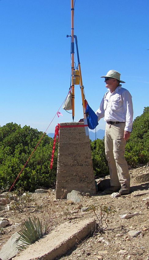
An overall view of what’s left of Michelson’s Lookout Mountain site with my GPS rig on top the pier with the Antonio benchmark.

Picture taken from the easterly pier, where Michelson’s mirror had been located, looking back towards Mount Wilson. The white observatory domes are just visible on the ridgeline to the left of the center pole. That’s 22 miles distant.
Anyway, come 4:15 PM I had everything staged and ready for quick disassembly and packing. At 4:25 I had just over five hours of data and deemed it good enough, stuffed everything into my pack and got the hell off the mountain. I drank half my remaining liter of water and started down with my headlamp already in my pocket, ‘cause, you know, just in case.
Part of my nervousness about the descent was I was heading down a different route to the saddle than my ascent. The GPS track I was using as guidance showed the route running up the spine from the saddle to the peak, something I couldn’t have done with my load, hence using the crappy, but more gradual, old use trail. I figured descent would be a simpler matter, but I didn’t really know the condition of that route. Turned out to be somewhat challenging, considering my low energy level, and I was ready to kiss the ground when I finally reached the saddle. But it saved me time over descending via the use trail.
I had guessed it would have taken me 30 minutes to reach the saddle but it was a little over 40. Still looked like I’d make it out by dark, or at least off the damnable ravine route in front of me. Since my GPS showed my route on the ascent, I just tried to stay with it on my way back down. I was pretty beat and stupid and managed to fall a few times. Fortunately the area was covered by oak leaf litter so the worst of it was I just looked stupid. And since there was no one around to see me, then I guess they really didn’t happen (Hey, I don’t make up these rules!)
It wasn’t until I had reached the paved road and the cabins that I could unclench. I made it back to the truck at 6:15 PM, where I had a number of cold drinks waiting in an ice chest. Cheated death again, but not by as much as I would have liked.
Three dumb-ass things I did I will not forget on future excursions:
1. Took a heavy load on an unfamiliar route with self-imposed time constraints.
2. Was overconfident on such a “simple” route and missed the turnoff, wasting time, energy and water.
3. Only brought enough water for a best case hike, and my decisions/mistakes made it anything but.
So, to the point of it all…….what about the data?
The way the data processing works with the NGS is that they match submitted GPS data against data they have from nearby fixed data acquisition stations, which allows the submitted data to be corrected for atmospheric and satellite errors. They get quick and dirty correction data in a day or so, pretty good corrections in two days, and their final corrections in about two weeks. Since there was no way in hell I was ever doing that hike again, I waited until the best satellite data was available. It was worth it.
Based upon the final satellite data my Longitudinal error was 7 mm and my Latitude error was 9 mm. Vertical is typically never as good as horizontal, but it still came in at 12 mm. So, an overall error box significantly smaller than a sugar cube. Here’s a link to the datasheet itself.
An obvious complement to this measurement would be to obtain permission from the Mount Wilson Observatory to do a similar measurement at the Michelson benchmark on the observatory’s grounds. This would allow for an interesting comparison of the distance between the two points as surveyed and calculated in 1923.
Unfortunately, the original site of Michelson’s facility at Mount Wilson is now surrounded by large pine trees. I know from experience my GPS-only receiver does not work well under tree cover (Some newer multi-system receivers might work, but those are tens of thousands of dollars, so……no). However, from the Michelson benchmark’s data sheet I see it was visited and its position adjusted by NGS surveyors in 1995, so its position is probably pretty accurate.
What I needed to do was take those 1995 coordinates for the Michelson benchmark, and bring them up to match what I had for the measurements I just acquired. This I did with the HTDP tool, available on the NGS website. Once I had the XYZ coordinates for the two benchmarks in the same datum, I used the Pythagorean theorem to compute the line-of-sight distance between them (Surveyors call this the chord). Computing the distance between the two Lat/Long coordinates would not have been correct since that computes an arc length, taken at sea level. So, after these assorted data manipulations I obtained a present day distance between the two benchmarks of….tadaaaaa!!!….35,385.576 meters.
Michelson’s 1927 paper on his experiment contains an appendix written by William Bowie, then with the US Coast and Geodetic Survey. Bowie describes in detail the surveying effort and states they obtained a distance between the two benchmarks, in 1922, of 35,385.53 meters.
Subtracting the two values indicates the distance between the two benchmarks has increased approximately 4.6 centimeters in the past 95 years. Well….Not really.
You see, Bowie also discussed what the actual error might be for the original survey’s distance between the Michelson and Antonio benchmarks. He estimated the actual error to be between 1 part in 500,000 and 1 part in 1,000,000 (Don’t confuse Bowie’s much lower “probable error” of 1 part in 6,800,000 as the actual error since probable error is merely a measurement of how consistent a series of survey measurements are. Probable error is a measure of precision and actual error is a measure of accuracy. For my purposes here, I want a measure of accuracy.)
Translating these values into an easier to understand format, Bowie’s error estimate for his measured straight line distance is between 3.5 and 7.1 centimeters. If you combine the error I obtained for my Antonio GPS measurements (about 1.5 centimeters) with Bowies’s error estimate, it turns out the likely total error range is larger than 4.6 centimeter difference I calculated. So the measurement difference could be due solely to measurement errors and not mountains moving. So I can’t say anything one way of the other as to if the benchmarks have moved.
On Lookout Mountain. You will NOT see me here again…
Back to the The Mount Wilson-Mount San Antonio measurements (1922 – 1926)