Since it’s been summer and Joshua Tree has been either too hot or just plain closed due to the government shut down, it’s given me impetus to do something I’ve been wanting to do for a while but have been too lazy. That is, work up a better picture of exactly what areas have been cleared by all the searching to date in the area.
What I had in mind was that instead of just using lines of a fixed pixel width to show the search tracks in Google Earth, perhaps there was a way to show a scaled width. That is, a person hiking through an area is able to observe some distance to the right and left thus clearing a defined swath of area. I figured this should be a simple thing to do with a GIS program….if I had a GIS program and knew how to do it. Instead I had Google Earth and kml files.
After a lot of hunting I discovered the following command:
<gx:physicalWidth>XX</gx:physicalWidth>
If this is inserted into a kml linestring file at the right location, XX can be specified as the line width in meters. Neat!
I decided to pull all the tracks between Quail Mountain and Smith Water Canyon, as well as those tracks northerly of Smith Water. The original search tracks from June/July of 2010 were left as black and those search tracks since then left as red. All the tracks were edited to have a line width of 50 meters (164 feet). My assumption was that clues could be reasonably seen within 82 feet on each side of a searcher. This was probably overstating it a bit when looking upslope but very much understating the observable distances when looking down slopes, but on the whole a reasonable estimate. Your mileage may vary.
After bringing them into Google Earth they were set to be mostly transparent. By doing so when search tracks overlapped, the color, either red or black, got much darker. Thus the darkness of color in a specific area is a direct reflection as to how well it has been covered.
Here are screen grabs of what the final product was, using both a satellite image and a topo map as a base map. Following those, there is a closeup view of the southeast slopes of the mouth of Smith Water showing the coverage.
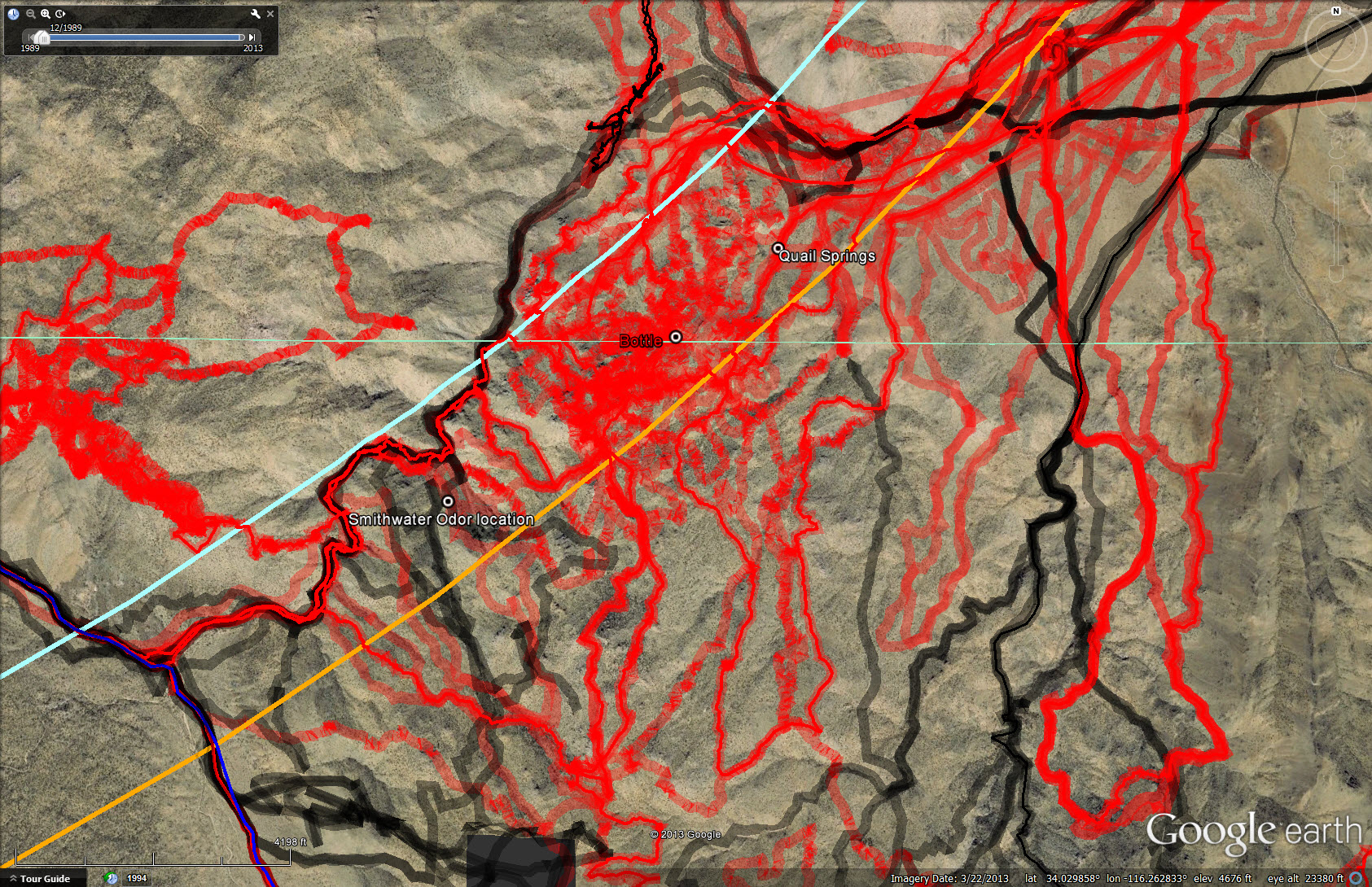
Looking down on the extent of Smith Water Canyon showing search tracks and areas clear to date (October, 2013). This is using a satellite image as the base map.

Same coverage as the previous satellite view but using a topo map as a base for clarity.

Looking southeasterly across Smith Water canyon at its southeast slopes. Note the extensive coverage to date of the steep slopes. The lower parts of the bowl, to the left in the image, are fairly open and have been scanned from above.
I found it all very enlightening. Areas near the southeast mouth which I still harbored some interest in look like they’ve been covered quite well. Lots of dark red. There are a few holes but nothing really too intriguing. The significant holes that do remain are in extraordinarily nasty areas on the south slopes in central Smith Water. We’ve made a few passes through there, but always going downhill….very carefully. What to do about those will require some thought.
To really get a sense for the coverage you have to download the kml file, load it into Google Earth and twirl it around yourself. So here it is:
KML file for 50 meter search coverage
As an alternative, I did a fly-through in Google Earth and saved it to YouTube. It’s not that great but if you don’t want to mess with Google Earth yourself it’s a good way to get a feel for the search coverage as well as the terrain (If you have 12 minutes of your life you never want back). Of course I do need to mention I’ve learned the hard way that Google Earth makes the ground surface appear much smoother than it actually is. At the end of the fly-through I added a flight from the Quail Mountain ridge taking the most direct route toward Smith Water. This was the idea I was struck with during my JT53 hike to Quail Ridge. That could be a fun trip…..