For his initial speed of light measurements, Michelson selected a location about 22 miles away, on top of a prominent high point of a ridge running down southerly from 10,068 foot high Mount San Antonio (known as Mount Baldy to the locals). Michelson’s choice was located about 3.25 miles southwesterly of Mount San Antonio and at an elevation of 6,812 feet. On 1926 maps it was named “Baldy Lookout” due to the presence of the first Forest Service lookout tower in the San Gabriel Mountains. Today, it’s generally referred to as “Lookout Mountain”. In all Michelson’s documentation, he referred to the site as “Mount San Antonio”, though not technically correct.
The site was constructed in the Summer of 1924 by Fred Pearson. In June of 1924, Adams sent a letter to the Ontario and Upland Telephone Company asking them to upgrade the phone line between Upland and Camp Baldy in anticipation of the upcoming tests. Given the remote location, there was little that could be done for the telephone line.

Original design sketch of San Antonio installation by F.G. Pease (Material courtesy of the Huntington Library, San Marino, CA)

Huts at San Antonio station – Lookout Mt. (original source Mike Keenan)
The first round of Michelson’s measurements were made in August of 1924. These he presented in a paper titled “Preliminary Experiments on the Velocity of Light” which was published in the Fall of 1924. In that paper Michelson gave the speed of light to be 299,820 Kilometers per second, accurate to about 1 part in 10,000. But he thought he could do better.
He returned again during the Summers of 1925 and 1926 making a more extensive series of measurements. His 1926 measurements were what Michelson referred to as his “definitive measurements”. From these he obtained a speed of light in vacuum of 299,796 Kilometers per second. These results Michelson published in his 1927 paper, “Measurement of the Velocity of Light Between Mountain Wilson and Mount San Antonio”.
For comparison, the speed of light measured by modern techniques is taken to be 299,792.458 Kilometers per second. Thus Michelson’s “definitive measurements” were only off by 3.542 Kilometers per second, or 0.00118%. That is phenomenal for measurements done almost 90 years ago!
The Pasadena Base Line
The most critical part of Michelson’s effort to measure the speed of light was knowing precisely how far apart the mirrors reflecting the light pulses were. And with the case of San Antonio being selected as the remote location from which to reflect the pulses, it was perhaps the most difficult part. The distance between Mount Wilson and San Antonio was a bit over 22 miles, and the intervening terrain exceptionally rough. Using the techniques of the day, it was impossible to directly measure the distance. For assistance, Michelson turned to the United States Coast and Geodetic Survey (USCGS), the best surveying group in the United States. They devised a method to measure the distance Michelson needed to an accuracy level that was the highest ever made to that time.
Clement L. Garner, of the USCGS, had the idea to establish a roughly parallel base line through the valleys at the base of the San Gabriel Mountains. From this baseline, triangulation shots could be taken of both Mount Wilson and the San Antonio station, and the distance computed with high accuracy. The survey work began October 16, 1922 and concluded March 1, 1923.
The crews used special 50 meter long Invar steel measuring tapes, calibrated by the National Bureau of Standards. In the cases where the grade in the areas they were measuring exceeded 10%, special wooden towers were built to keep the grade below 10%. In one memorable situation, a house was in the way of their baseline. Fortunately the homeowner was cooperative and the windows lined up just so, and the team pulled the baseline through the house.
Upon completion of their work, the USCGS felt that the distance they reported between Mount Wilson and San Antonio to be correct to 1 part in 500,000, or about 3 inches. The effort was so noteworthy that it resulted in the publishing of a paper in 1924 detailing how it was all accomplished (“A Geodetic Measurement of Unusually High Accuracy”, by Garner).
It also attracted the attention of the press. Here’s a report on the work in the Los Angeles Times of July 17, 1927.

Setting the Pasadena base line (NOAA image library)

Passing Pasadena base line through dwelling (NOAA image library)

Tower construction for measurement over steep terrain (NOAA image library)
For a closer look at the Pasadena Baseline (and executed in a manner far more polished and slick than anything I could pull off!), I highly recommend a visit to a page created by professional land surveyor Jay Satalich.
The site today
This is an, uh….interesting site to get to. There is no easy way, just various flavors of hard. There is no formally maintained trail to Lookout Mountain, but there are what are known as “use trails”. These are routes that get enough hiking traffic to become visible and look like trails. But the Forest Service doesn’t actually maintain them so their quality can vary quite a bit. And you can get lost.
Rather than me telling you how to get to Lookout Mountain, I’ll refer you to the following two links for detailed instructions:

Approx view as in old hut image (T. Mahood)

Forward pier with new reflector pointed at Mount Wilson (T. Mahood)

Antonio benchmark on top of forward pier (T. Mahood)
")
Rear piers of the San Antonio station (T. Mahood)

Sight line to Mount Wilson from rear piers (T. Mahood)

Trailhead parking area below and to the right (T. Mahood)
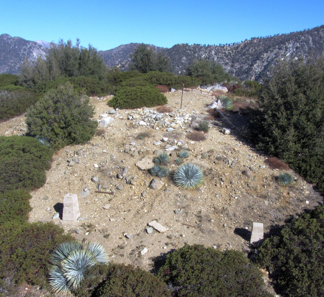
An aerial view of the site looking northerly, showing two of the three concrete piers. The rightmost pier is now completely obscured by the overgrown brush. Imaged on 10-14-2014
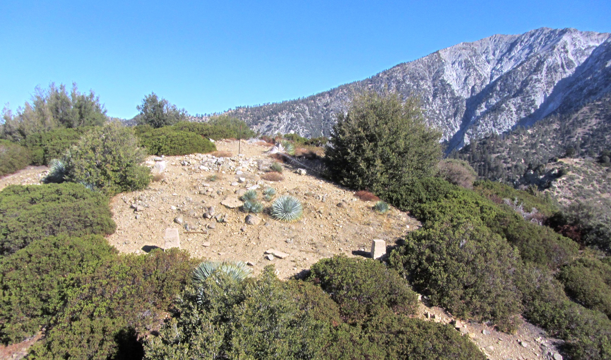
An aerial view of the site looking northeasterly, with Mt. Baldy in the background. Imaged on 10-14-2014.
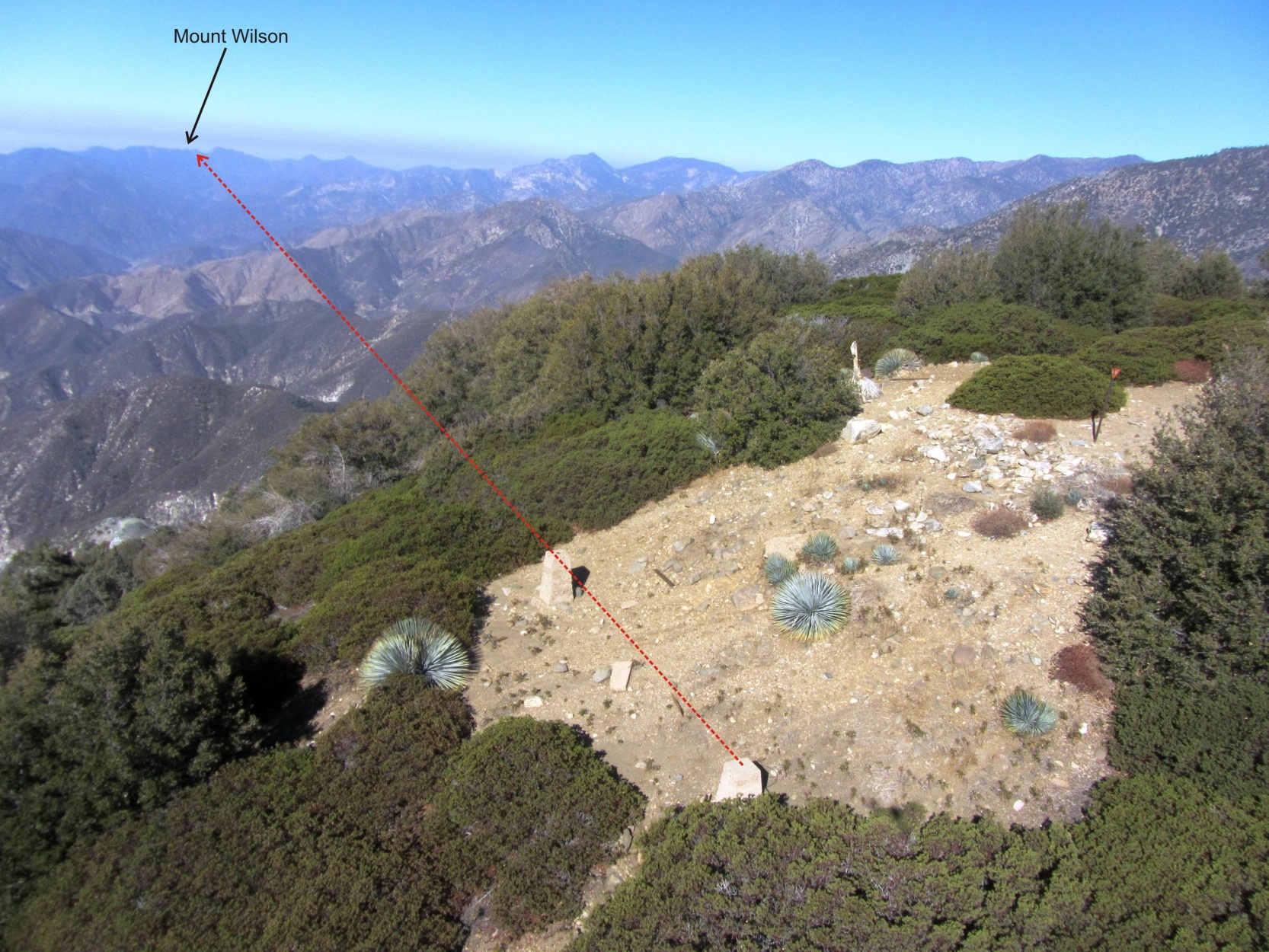
An aerial view of the site looking westerly. The red dashed line is the approximate return beam line to Mount Wilson, just over 22 miles in the distance. Imaged on 10-14-2014
Hey, wait….Before you go, you might want to have a look at this update I did, returning to Lookout Mountain with some survey grade GPS gear in October of 2017 to take a measurement of the benchmark and compare it to the 1922 measurement. Or not.
Back to Historic Speed of Light measurements in Southern California