Date: 10/30/2013
Participants: Tom Mahood
General search area: The northerly facing slopes of the central bowl area of Smith Water Canyon.
Rationale for searching this area:
Having now pretty much searched out the area at the southeast mouth of Smith Water Canyon, my attention has turned to the central Smith Water area as the next likely spot. For a further discussion as to why I now think this is so, please see the Comments section of my JT54 report.
Specifically I planned this route to fill in gaps in earlier coverage in this area and to remain in terrain of reasonable risk for a solo outing. Well….that was the plan anyway.
Impressions of area and findings:
Even having been down these slopes a few times prior, I was surprised at the ruggedness of the terrain. There were so many places someone could easily get hurt and equally many where they wouldn’t be seen. It makes the terrain of the SE mouth of Smith Water seem warm and cuddly. Viewing it in Google Earth makes it appear much smoother and more benign than it actually is.
Coverage level:
I’d estimate my coverage to be 80% within 75 feet of my travel path at a minimum, and in a few areas a much wider swath. I think my 50 meter swath reasoning holds for this search. In the chute areas I tried to do as much overlapping as possible to ensure I didn’t miss anything.
Unfortunately the lighting for much of the time was a bit sucktastic. Many areas I scanned with binoculars were in shadow, as the slopes I was interested in were either north or west facing. This resulted in seeing not as good as it could have been.
Comments:
The initial part of my search was focused on the side canyon originally cleared by the Sierra Madre team on 7/03/2010. Teams had been along the top and bottom of the canyon, but I was interested in covering the side slopes. While I was exploring the westerly slopes of that canyon I often stopped and spent considerable time scanning the easterly slopes with my binoculars.
This technique clearly worked as I did spot some bones tucked away in the rocks on the east slope. I couldn’t see them without the binocs, but I tried to take some zoom pictures of the area anyway. The bones appeared too white and bleached to have been recent, but I resigned myself to making the cross-canyon trek to check them out. They turned out to be fairly old Big Horn Sheep leg bones and perhaps a clavicle.
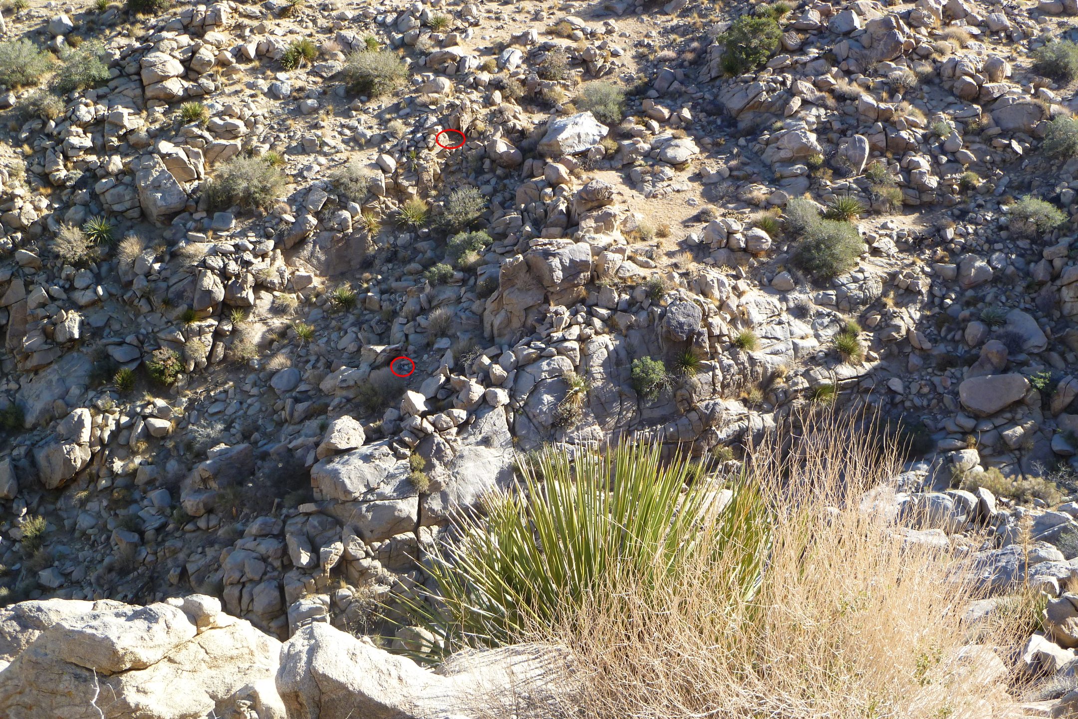
Can you see the bones? (Two locations, circled in red) This is a ZOOMED view across a fairly wide canyon. They popped out pretty clear with binoculars. Even so, I had to hike over and check for sure.

And……Here’s part of a clavicle on the left side of the rock opening.
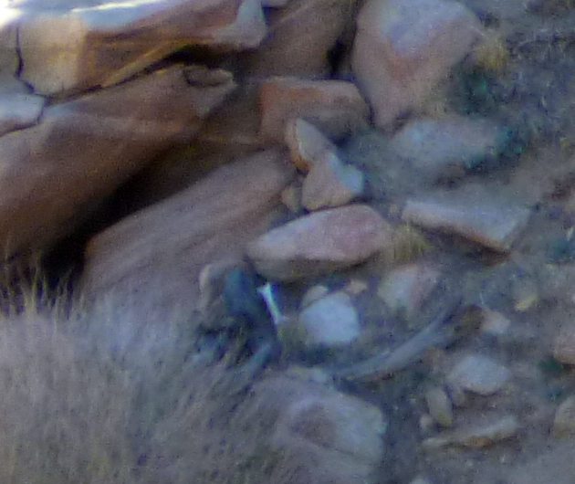
What, didn’t believe me? This is a very zoomed look at a Big Horn sheep leg bone.
From the bones I started climbing up to a point I suspected would provide a good vantage point from which to peer down into the bowl below. From there I was planning on heading up a little higher, through some open areas near the 11.1 mile radius, then back down to another viewpoint a little easterly of the first. From there I was thinking of exiting generally the way I had entered as I thought a solo descent down the bowl was a bit sketchy for a solo trip. That idea sorta changed…..
While at the first overlook I kept getting whiffs of a sour smell, sort of a “death lite” odor. Now I wouldn’t expect much if any odor from material left out in the elements for three years, BUT from the evidence of water flow in the bottom of Smith Water Canyon it appears it had rained here within the previous two days. And a little moisture could rejuvenate odor.
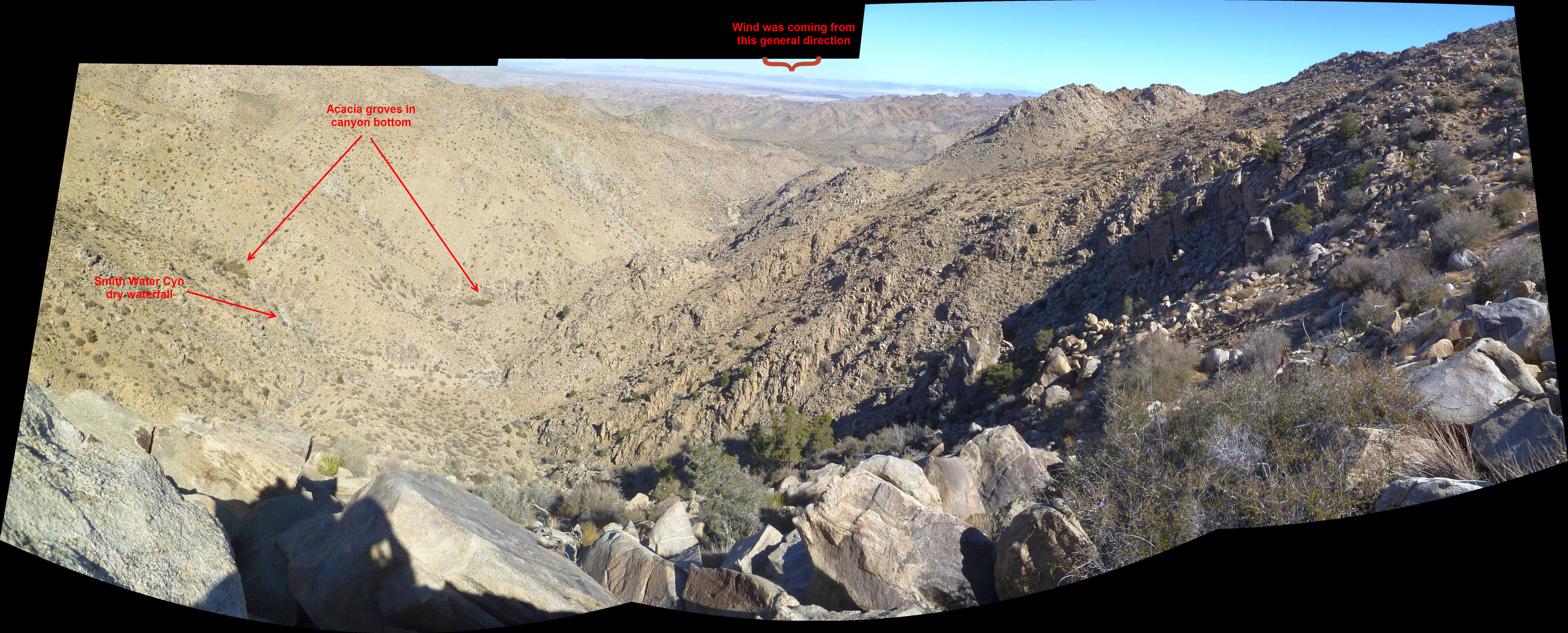
Annotated image looking down toward Smith Water Canyon from the top of the bowl. Quail Wash is in the flat area to the far right. Elevation drop to that part of Smith Water in the foreground is about 900′.
Here’s a real short video I took from the first overlook point to give a sense of the terrain:
There was a pretty good breeze blowing from the NNE. Looking in that direction, down below, there was a group of trees perhaps 80′ to 100′ beneath in the main chute. And lots of big honkin’ rocks. I started thinking maybe I should just drop down a bit and have a look, with the plan of climbing back up to exit. I pondered this after I left the overlook and explored the upper regions. And at the easterly overlook I studied the terrain beneath and thought I could see several reasonably safe routes all the way down to the originally reported odor location, from which I knew I’d be home free. Still I needed to continuously remind myself that discretion was the better (and safer!) part of….something.
The upper entrance to the chute was not bad at all, but I knew what lay below. I took things very slowly and moved with extreme caution. I also traversed a great deal in order to cover as much area as possible since I didn’t want to go back. On a few occasions in the chute I thought I again smelled something foul and am pretty certain it wasn’t me.
I made my way out of the chute and over to the trees I had seen above and used as a marker. Nothing to be found there. From there I had a good look at the slope further below and it looked doable, so back I went to the chute. At that point the dry waterfalls began which made things…..interesting. I managed to avoid the craziest part of falls but was fairly confident that I could see to their bottoms clear enough.
I noted a couple of things about this descent. The first was that how easy it would be for someone to get themselves seriously injured here. The idea of someone tired and dehydrated making it safely down seemed very unlikely. But that’s not obvious until you are well into the descent and committed.
The other thing that was strongly on my mind is I really felt like I could come across Bill at any moment. That’s a feeling I’ve seldom had on these searches, perhaps because I’ve become an expert on NOT finding him. But here, everything felt absolutely right, down to the rocky cliffs just above acting as a reflector to the Serin Drive cell tower.
But, as has become a tradition for me, I was wrong again. No Bill. As I descended below the dry waterfall area of the chute I no longer was able to pick up any sense of odor. Along the way I gave a lot of vegetation a quick sniff test to see if that was what it was from, but I could never locate it. So I’m at a loss to explain what it was, if it wasn’t just my imagination. I am fairly confident I cleared the rocky areas in the upper chute, and even if I missed some small portions, “stuff” should have been scattered after three years. And this area was absolutely pristine.
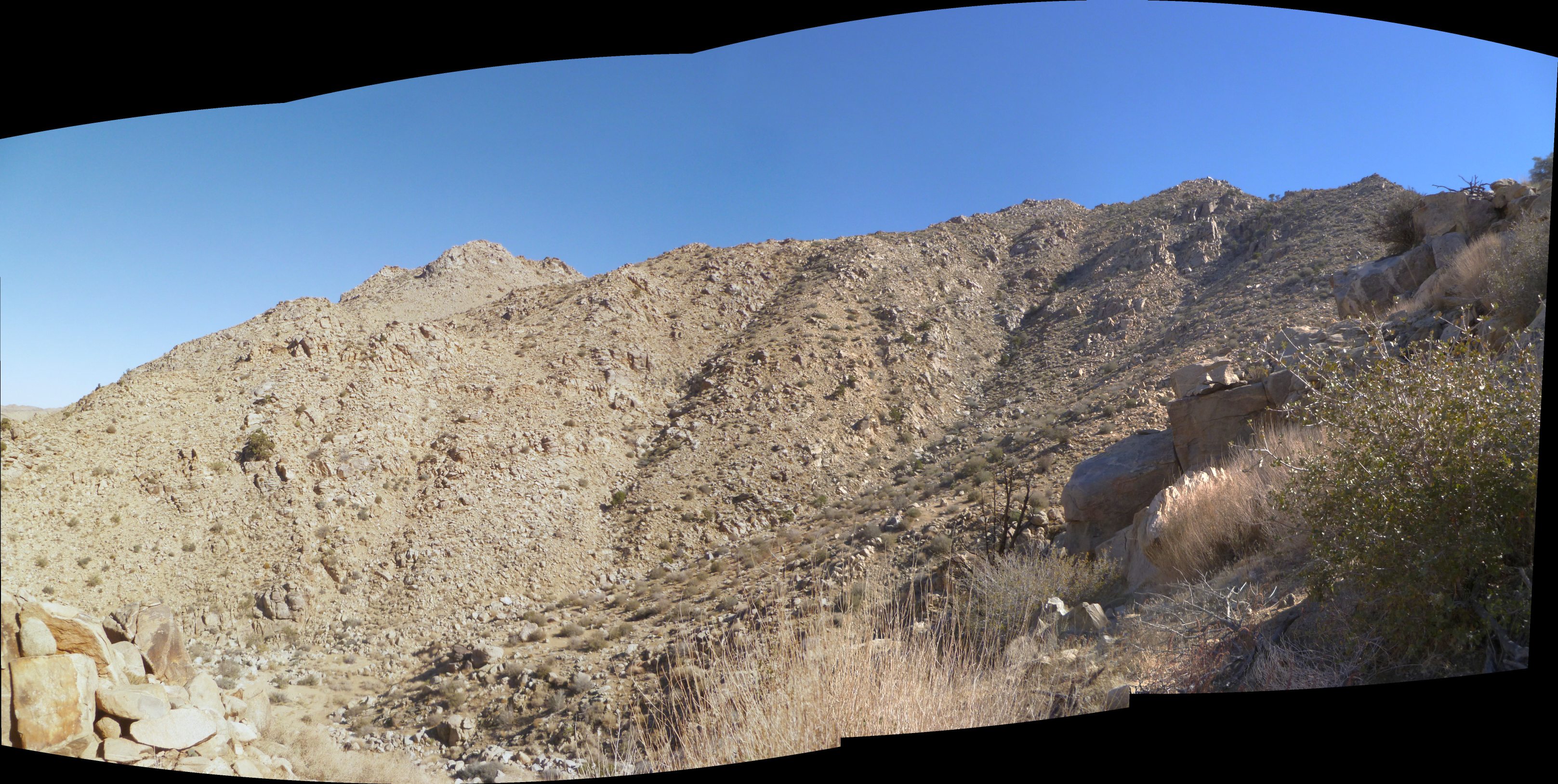
Looking at the easterly slopes of the central Smith Water bowl from near the bottom. The location I took the pictures from on top is the small, pointy peak almost at the right edge of the ridgeline. The chute is the shaded rocky area just to its lower left. Be advised this image makes it appear MUCH less steep than it actually is. Looks easy, doesn’t it?

This is a zoomed in view of the upper chute area from below. In its center are the dry falls I wrote of. The peak I first noted the odor from is the point on the right and it seemed like it was coming from the rock area. Again, terrain in this image is steeper than it appears.
So….I don’t know. And I’m uncertain how much weight I should place on it. I expect a few more trips into that bowl area so perhaps a detour could be made to further explore the upper reaches of that chute.
The tracks my GPS recorded of the lower part of my descent back down into Smith Water are a bit wonky. I was checking my GPS unit at the time to ensure I was on the correct path for an earlier earlier route that avoided the man-eating Acacias. I was surprised to see the GPS was not showing my correct position and the error circle was very large. I expect it was due to poor visibility of enough GPS satellites when deep in the canyon and I have experienced it before. I ended up editing the tracks for the lower portion of the descent to better reflect where I was. But they are sort of approximate.
During this period of PMS GPS, I stumbled across the remains of a Big Horn Sheep carcass just off the main Smith Water Canyon. There was still a small bit of tissue on the bones and it appeared to be only a few years old. What surprised me was that I had been near here on prior trips and hadn’t noticed it. I had to be right on top of it to see it.
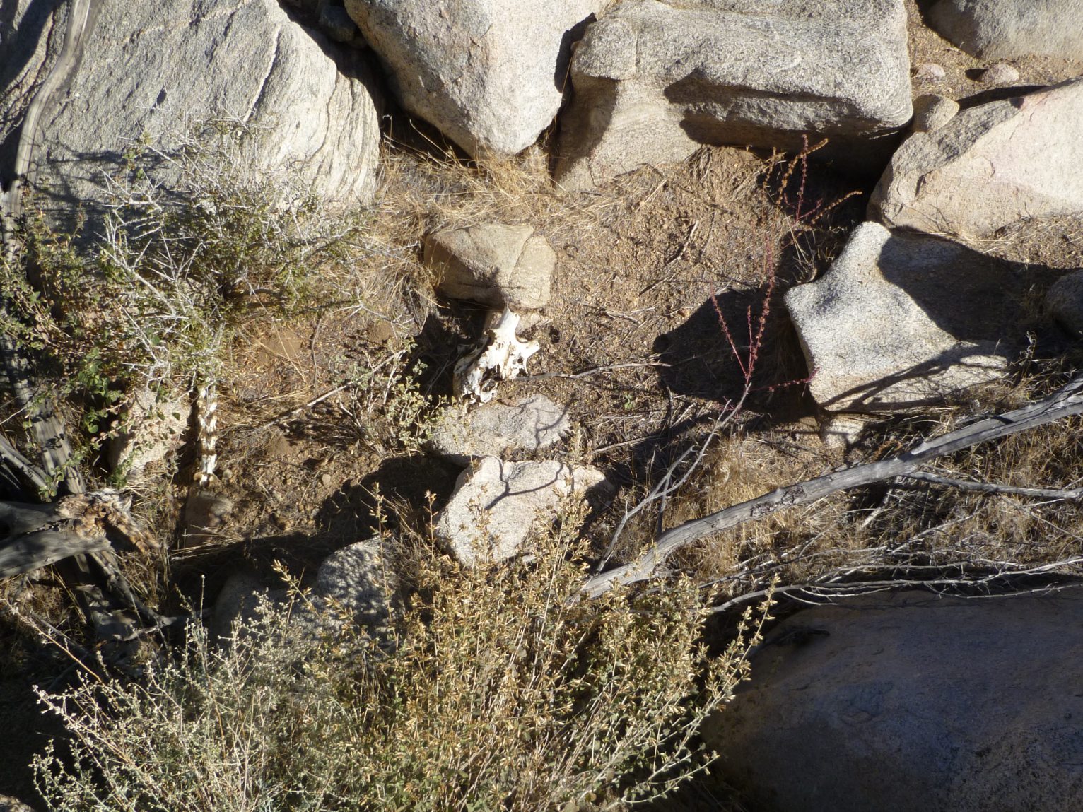
A look at the Big Horn Sheep carcass just off the main canyon. There were other bits and pieces scattered nearby.
Normally I don’t provide the locations of Big Horn skeletons (or other interesting stuff) I find in the back country. But this one is different as it wasn’t far from the recorded Smith Water “odor location” from the initial search. It left me wondering if this could have been the source of the reported odor? I’m inclined to think it wasn’t, as teams passing near it in Smith Water should have been able to pick up the stench if it was fresh. Or maybe it wasn’t that old. But still….Anyway, even though I took a GPS reading at the precise location I noted after the fact it was fairly far off. The location shown is my best estimate from what I know of the location.
GPS mileage for this trip: 6.9 miles
Cumulative GPS mileage to date: 723.8 miles
GPS tracks for this trip in Google Earth kml format
GPS tracks for this trip in Garmin gdb format
GPS tracks for this trip in gpx format
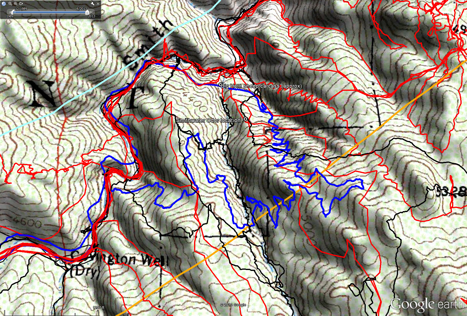
Overall tracks to date in the central Smith Water Canyon area. The black tracks are from the original search, red tracks those made since since, and JT56 shown in blue. The light blue line is the 10.6 miles radius from the Serin Drive cell tower and the orange line the 11.1 mile radius.

Overall tracks to date in the central Smith Water Canyon area showing a 50 meter swath of visual coverage. The darker the color the better visual coverage that area has received.