Date: 10/22/2013
Participants: Tom Mahood
General search area: The southeast slopes of the mouth of Smith Water Canyon.
Rationale for searching this area:
This was a combination shakedown hike (first of the season) and sort of a mop up of unsearched areas in the SE Smith Water Canyon area. Having just completed the exercise of laying out 50 meter coverage swaths along previous search tracks it was obvious there were a few holes left in the coverage of this area. In essence, filling these in would provide (theoretically) fairly complete ground coverage of the SE Smith Water area.
Impressions of area and findings:
I quickly discovered why the spots I had targeted were holes in previous search coverage. They were mostly pretty ugly pieces of terrain. Still, in a burst of OCD, I dutifully hit them all.
Coverage level:
I’d estimate my coverage to be 80% within 75 feet of my travel path at a minimum, and in some areas a much wider swath. I think my 50 meter swath reasoning holds for this search.
Comments:
Over Summer I deliberately avoided thinking of this problem to give myself a break and approach things fresh. Between that break, the coverage analysis I just completed, and this mop up I’ve come to a few conclusions.
- The idea of Bill heading to Smith Water Canyon to reload on water, and him viewing it as a non-emergency situation, still seems to best fit what we know at this point.
- Bill must be within an 11.1 mile radius of the Serin Drive cell tower, and probably closer to the 10.6 mile radius. Given how the Verizon cell system figures distance from the tower, any place further out is probably a waste of time.
- Smith Water Canyon puts a hard northerly limit on Bill’s travels. It seems very unlikely he would/could have passed beyond Smith Water. Thus he’s to be found somewhere between the 11.1 mile radius and Smith Water Canyon.
- After fairly extensive searching, I’m now of the opinion Bill isn’t going to be found in the SE Smith Water area. He’s somewhere else.
In hindsight, there was a flaw in my reasoning that made SE Smith Water look so attractive. I made the assumption that Bill experienced some injury before reaching the crest of Smith Water, when he was north of Quail Ridge in the canyons with no cell coverage. And to get into Smith Water there’s only two ways to do so without passing though an area of excellent cell reception at the southerly rim of the canyon.
One is to pass through an obvious saddle to the west of the rim high point (imaged below from Quail Ridge on my third anniversary hike….It’s just to the left of the center flat ridgeline) then down a narrow canyon to the bottom of Smith Water. The lower parts of that canyon had been covered well by the Sierra Madre team during the initial search and the upper parts have been covered on two other searches since. So Bill’s not in that canyon.

A zoomed panorama looking toward Smith Water from the Quail Mountain ridge. The level of rockiness approaching the crest becomes apparent in this zoom. It’s not visible when viewed normally from this distance.
The only other way to get to the 10.6 mile radius without pinging the tower would be to travel to the northeast, staying somewhat lower and below the cell coverage zone, and finally arriving at the SE slopes of the mouth of Smith Water. I explained that reasoning here. It made a lot of sense until searching showed Bill wasn’t there. Again, another case of a beautiful theory spoiled by ugly fact.
Thinking things over on the hike out I realized I may have underestimated Bill’s abilities. I just assumed he got injured well before he got to Smith Water, thus explaining the considerable span of time before the cell ping. An injury would have slowed him substantially and could explain the odd timing.
But suppose Bill was doing fine as he reached the southerly rim of Smith Water. At that point he’d be able to see the bottom and “only” had to descend 1,200′ to get to the water. Even though he was in the middle of great cell reception there was no need to turn on the phone or call for help. So down he starts.
Now having been in this area a few times I will swear an obscenity-laced oath that the central Smith Water Canyon area is some of the nastiest and most difficult terrain I’ve encountered in this effort. Yes, worse than the SE Smith Water area. I say this as someone who was well equipped, hydrated, rested and with hiking poles. The chances of someone tired, dehydrated and without poles successfully making that descent seem slim. The chance of becoming seriously injured or incapacitated are large.
Have a close look at the image below. I think Bill’s somewhere in it. It’s part of a larger image I took on our JT44 trip, which was a reconnaissance of Smith Water from the northerly slopes of the canyon. It’s pretty much taken looking due South. The black lines are the tracks from the initial search, and the red lines tracks since then, updated to the most recent. The orange line is the 11.1 mile radius from the Serin tower. There’s a bit of blue line to the lower right, which is the 10.6 mile radius. But the 10.6 mile radius is essentially the canyon bottom.
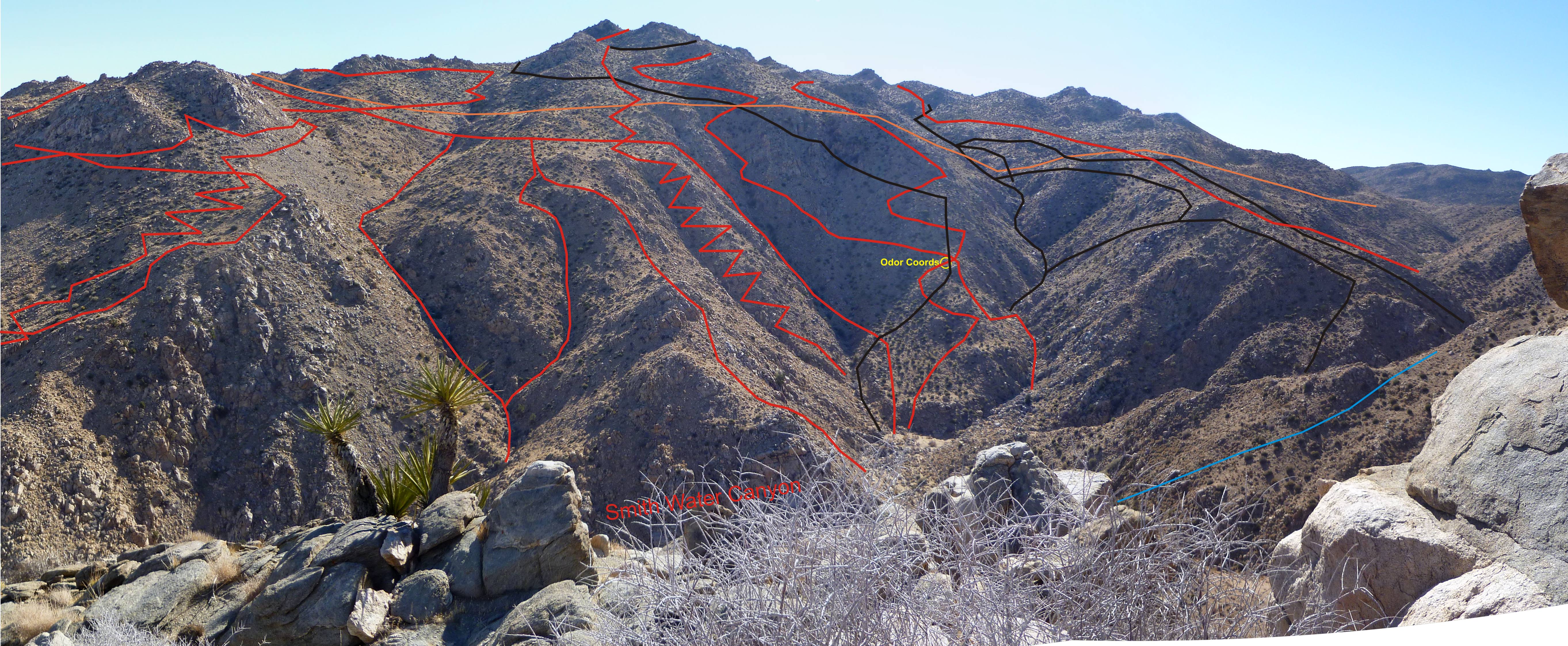
Looking southerly toward the southerly slopes of the central Smith Water Canyon area showing approximate cumulative search tracks to date.
There are few things that aren’t immediately obvious in the image. The first is that the area above the orange line is a zone of excellent cell coverage. Descending below the orange line cuts it off. Also that peak in the image is the back side of the high point visible in the shot I took from Quail Ridge. Not having a GPS and being a map and compass kind of guy, Bill would be inclined to sight on a distant landmark for navigation purposes. And that peak would certainly serve that purpose to get to Smith Water.
Note that right smack in the middle of the image is the reported “odor location”. Further note that above it and to its left, just below the orange line, is some appallingly nasty terrain (I speak from personal experience as the two red lines to the left of that area were mine and the one to the right is the ever-gullible Paul Caraher). And as a final observation, those nice, vertical rock faces generally point at the Serin Drive cell tower. Can you say, “reflector”?
So from a possibilities viewpoint, I like this bowl area a lot. From every other sensible viewpoint, I loathe it. It’s a scary place to be climbing around.
The reported odor location deserves a bit of discussion. It was initially reported by Team 2 on 6/29 (Tuesday). It was then followed up by the Sierra Madre team on 7/3. No source for an odor was ever found. But something I always found a bit odd was that there weren’t any GPS tracks that went exactly to the reported coordinates (which I’ve triple checked). The image below shows the three search tracks of Team 2 in black and the reported odor location coordinates. None of the team’s tracks actually hit the location. (Note: The black line that’s shown passing through the odor location’s coordinates was from Team 1 on 6/30, after the location had been reported.)
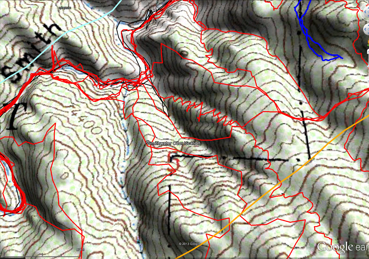
Reported odor location coordinates as compared to the actual GPS tracks (in black) of the search team that reported the odor.
Looking through the search records shows that Team 2 had three members. There were also three GPS tracks turned in for the team. So it’s not like there was someone along who didn’t have a GPS and noted an odor. I’m thinking the odor was actually noted where the one black track jogs off to the SE from the main canyon, stops then returns. This spot is in the canyon bottom easterly of where I’ve been showing the odor location. The red line that passes through where the black line turns back was me on the Smith Water Death March (JT27) descent. I was probably so happy to be back on the flats I wasn’t looking around very carefully. But higher up that drainage remains a good possibility.
Access to this area is difficult at best. To get to the spot in Smith Water just beneath the odor location from the usual Samuelson’s Rocks trailhead is about 4 1/2 miles with a total elevation differential of 750′. To the same spot from the Covington trailhead is 2.3 miles and 600′ of elevation differential. Both routes require traversing meat-eating Acacias groves in the bottom of Smith Water Canyon. And then the climbing begins. This isn’t an area you want to be in unless you really know what you are doing and know how to manage risk.
GPS mileage for this trip: 10.0 miles
Cumulative GPS mileage to date: 716.9 miles
GPS tracks for this trip in Google Earth kml format
(Note: I’m providing the kml file with the new 50 meter swath display that I’ve now adopted as my standard practice)
GPS tracks for this trip in Garmin gdb format
GPS tracks for this trip in gpx format

Cumulative search tracks as of JT54. JT54 tracks are in blue, initial search tracks are in black and other tracks since then in red. The light blue line is the 10.6 mile radius from the Serin Drive cell tower and the orange line is the 11.1 mile radius.

A perspective view, looking southerly, at the cumulative search coverage in the SE Smith Water area. Blue track is JT54. Note that the vertical slopes below the “bottle” location have been extensively covered.