Date: 4/3/2014
Participant: Tom Mahood
General search area: Steep southerly slopes of Smith Water Canyon easterly of the central bowl area.
Rationale for searching this area:
As coverage in the Smith Water Canyon area has accumulated, there were three remaining areas not yet covered by ground search due to the steepness of the terrain. This trip covered those areas optically from a high point on the northwesterly slopes of the canyon.
Impressions of Area and Findings:
There were three primary areas of interest, two near the canyon bottom and one further up a side canyon. In the case of two of the areas, their steepness precluded safe ground coverage. Beyond that, none of them seemed like plausible locations in an absolute sense. However they represented three of the few remaining holes in the coverage in Smith Water Canyon.
The two areas nearest the canyon bottom (and near the 10.6 mile radius) are very steep and rugged. To examine them I found a prominent saddle located about 500 feet above the canyon bottom on the canyon wall opposite these areas. From there I was able to get a very good view of the two nearest areas using binoculars, as they were only about 1,300′ away. The third area was about level with me and perhaps 2,000 feet away.
Coverage Level:
50% – 60%?? It was very hard to estimate. Much of the area was easily visible. However when viewing from only one spot, sightlines are often obscured by rocks.
Comments:
There is really no likely reason I could think of that Bill might have ended up in any of these three locations. That said, they represented some of the few holes left in the ground coverage and really had to be checked out. Realizing the ugliness (and danger) of trying to do it on the ground, a “virtual search” from the opposing canyon wall made sense.
The location I selected on the northerly canyon slopes was only about 750 feet southerly of the location that Patrick and I were at on our JT44 trip where we did something similar. However on that trip we reached our location in a descent from from above, coming from Lower Covington Flat. To get to the spot for this trip I climbed up from below, something that sounds more reasonable when planning it out than when actually looking at it. Of course that could be said of many things I end up doing.
As I’ve grown to loathe Smith Water Canyon a bit, rather than descend and return the way I came, when exiting I continued climbing and headed directly toward Lower Covington Flat. Once the climbing ends and the top is reached, it’s really a pleasant area up there. The surrounding views are great and it’s almost never visited. And there was serious wildflowerage going on.
GPS mileage for this trip: 5.0 miles
Cumulative GPS mileage to date: 760.8 miles
GPS tracks for this trip in Google Earth kml format
GPS tracks for this trip in Garmin gdb format
GPS tracks for this trip in gpx format

The tracks for JT62 are shown in dark blue, the original search tracks are in black, and searches since then in red. The light blue line is the 10.6 mile Serin cell tower radius, and the orange line the 11.1 mile radius.
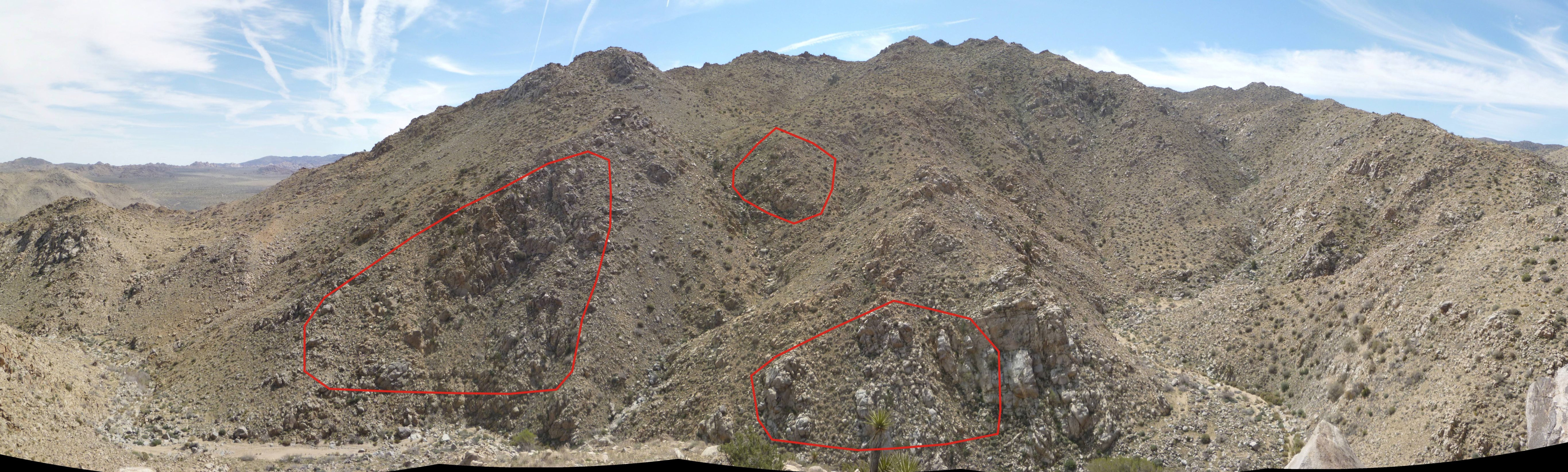
In this panorama looking southeast, the three areas of primary interest are outlined in red. The central Smith Water bowl area is the right third of this picture.

A telephoto image of the furthest area of interest. My binoculars gave me an even closer view than this.

Wildflowerage