Note: Report written by Adam Marsland
Date: 5/24/2014
Participants: Adam Marsland, Teresa Cowles
General Search Area: Immediately west of Upper Covington Flat
Rationale for searching this area:
A new possibility has been raised that Bill might have become lost somewhere westerly of Stubbe Springs and made his way north to this point, pinging the towers two and a half days later.
Impressions of Area and Findings:
The area from Upper Covington Flat to the low lying hills one mile west is relatively easy terrain. The area is fairly level (though slightly sloping upward to the east) and the hills themselves are not that steep. Joshua and other small trees dot the area, but there is little brush to impede travel. To the west of these hills, however, the terrain plummets downward precipitously and spectacularly.
Coverage Level:
We did miss some areas, but we covered quite a lot of it. Perhaps 65% coverage. Tom also searched this general area on JT 48.
Comments:
My last trip to Joshua Tree, though it encompassed a low probability area with corresponding expectations, had shaken loose in my head a new theory of Bill’s disappearance, that was further refined after looking over maps of the area and running my ideas by Tom.
The question of why Bill would be as far north as he was, why he would travel to Smith Water Canyon, why it would take him two and a half days to get there (and if it was because he was seriously injured, why he seems to have then removed himself somehow from the heavily searched area), and how he would not ping the tower in the interim has been the most confounding aspect of the mystery of Bill’s disappearance.
The idea that formed in my head after looking over the area at Covington Trailhead on my last trip out, and then looking over maps of the area to the west and south, is that Bill could have been hiking in the Stubbe Springs area (much more logical than Smith Water, or even Quail Mountain, relative to where his car was parked, how late he started, and what his planned exit time was), and lost his way in the mountainous region to the west, consuming two and a half days finding his way back to some point north at which time he re-emerged, pinging the tower, and then came to grief. This would fit the facts we know better, and also answer something that’s bothered me since the very beginning of the search: why, in such a lightly traveled area, where signs of human passage stick out like a sore thumb, has no sign of Bill or any place he might have bivouacked ever been observed in any of the numerous searches? If Bill had been ambulatory but far from the search area, that would answer this question.
After verifying this possibility on a map, I ran the idea by Tom and asked him to shoot it down. He offered two objections. One is that the terrain in the Stubbe Springs area (which I have never visited) would tend to lead Bill southwest towards the Desert Hot Springs area, and that the topography would make it difficult for him to wind up where he would need to be for this theory to work, which would be in the area west of Upper Covington Flat. Tom’s second objection was that he did not believe there was any Serin coverage that far to the west. However, Tom and I were both bothered by the fact that the rugged western area had not been searched — and neither of Tom’s objections, while valid, absolutely ruled out this new theory. The more I thought about it, the more it nagged at me, and I resolved to get out there on the first relatively cool day I had free this summer.
That day turned out to be today, and with friend Teresa Cowles (who has proved on past occasions to be a much better observer than me), made a spur of the moment trip out to Joshua Tree to have a look at this area. We arrived at about 3 p.m., with a warm but pleasant sun high overhead, which gave us a heading to follow due west from the parking area at Upper Covington Flats backcountry trailhead to the area in question.
Our destination was the low hills one mile or so to the west, which roughly fell in these perimeters. This is a lightly traveled area, though Tom did do a search here once previously on JT 48. For the purposes of testing out this theory, I hoped this trip to the area would satisfy my own curiosity about these questions: did the topography allow for Bill to enter this area from the south? Could Bill have pinged Serin tower from this location? And should the search be expanded further west from this area?
We did not find Bill, but we were able to answer all three of these questions.
I have a Verizon phone; Teresa has AT&T, so were well equipped to test out the ability to send and receive. As we got close to the area in question, we were rather surprised to discover (given the topography and my experience with cell reception in the Smith Water area) that I was able to get a text out to her in a low area just as we were starting to climb into the hills.
As we got a little higher, we surveyed the topography and at first it seemed there was no way we could see to get up to the area from the south without either hitting an impassable mountain or dropping down into Coachella Valley. But a closer inspection revealed a somewhat steep, but totally navigable, wash making its way up from below. The wash, to the best we could see it, would offer a path upward that would be shielded to the southwest (and presumably from cell towers in Palm Springs) by high mountains. It was the only way in, but it was a way in. The topography made it clear that if Bill came to this area, it was through this wash.
Now, to pause a moment: assuming there was a way that Bill could make his way up this wash from the south and west, why would Bill pursue such a path when the terrain should have led him in a different direction? It makes me think back on the various hiking misadventures where I had tried to bushwhack my way to my original location by continuing to turn right or left, but being forced (often without realizing it) by topography or road design further and further from my desired destination.
If Bill was NOT injured and was in fact ambulatory for the two and a half days leading up the ping, and given his background, his mindset may not have been on obtaining or waiting for search and rescue but simply in getting back to his car and driving out. While it may be unlikely, it is conceivable that that may have led him to pursue an unconventional path once he had become lost — not following the natural terrain because it would have been taken him further away from where he wanted to go.
After surveying the area to the south, Teresa suggested that we go down and investigate where the wash came up to meet the relatively level land below the bluff we were on. Fanning out (she going more eastward), I went straight to the spot that seemed to offer the easiest and most logical exit point from the wash. Standing at that point, I got out my phone to check for reception. I was shocked to discover that I was able to get a text out, even though it was a depressed point just coming out of a wash and surrounded by higher ground. I could see a small sliver of land from the Coachella Valley below, so I theorized that I was actually bouncing of a tower somewhere down there. To check this and view other possible but more difficult exits from the wash, I moved further south, meeting Teresa on a high bluff overlooking a large chunk of the valley below. Teresa confirmed she’d gotten the text I had just sent. At this spot with better line of sight to the valley below both Teresa and I had bars, so this seemed to confirm the Coachella cell tower theory — until I tried to get a text out from there. I could not. Teresa, on AT&T, had reception and tried to call me. The call appeared to ring through from her phone. My Verizon phone, however, stayed silent. I had no reception.
We decided then to proceed north toward higher ground to further search the area and test our phones out. I also wanted to gain impressions of the land to the west. Teresa went straight north whereas I followed a meandering course, partly in the remnants of the wash (which did continue, narrowed and less steep, past the point where I had gotten the text out) which continued north and slightly west and upward. I observed that there were depressions in the wash that could have been very old footprints. There was no way to know, but it was notably for the lack of those kind of depressions in other areas we had searched.
I followed the topography up to its logical ending point, and started looking around. Here I got a dramatic answer to the question: if Bill had actually continued all the way up the wash (or got out and walked nearby), could he have then turned west? The answer is: unless he was suicidal, no way. The land fell away very steeply and dramatically at every point to the west, ranging from extremely steep with no traction to an almost sheer drop. I did my best to scramble along the top to look down, but it seemed very unlikely anybody would fall here (it would be easy to avoid), and insane for anybody to try to exit this way. If Bill had come up the wash and out, no matter at what point, he either would have gone east or north. Not west. From the looks of it, barring an unlikely catastrophic fall, the low lying hills west of Upper Covington Flat would probably be the hard western limit of where to look for Bill.
Teresa and I met up again at a height of land northwest of where the steep area was. At this point there was a great view to the southwest and large swaths of the valley below were visible. If I had earlier gotten reception from Palm Springs, my phone should have been lit up like a Christmas tree here. Instead it read “no service.”
We paused and considered the implications of this. Before we started out I had figured, at best, we might get a few bars at the height of land to our north that could possibly be from Serin tower. Instead, we got a text out at the most logical exit point from the only route into the area from the south, but were not able to duplicate this in nearby higher areas with better exposure to the southwest. We were left with the surprising conclusion that, in all probability, at the exit from the wash somehow we’d likely pinged a tower to the north — Serin. (Since this is a bit confusing, I’ve attached a graphic to illustrate the pattern of topography and cell reception we observed in the area)
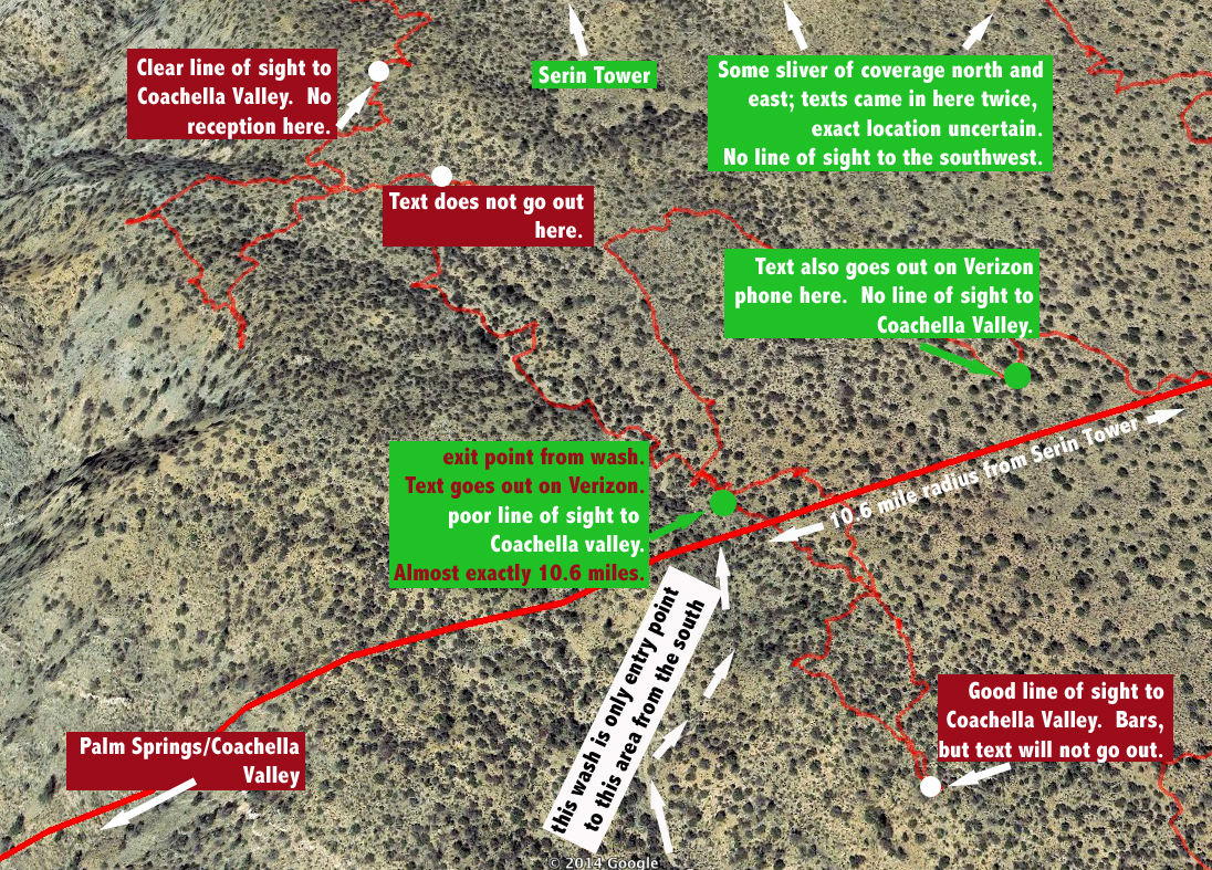
Exhibit prepared by Adam Marsland to accompany his JT64 report.
We decided that we should make as thorough a search of the area to our east, between these hills and the road, as we could manage in the daylight left remaining. We headed north, then east, then turned south, fanning out for maximum coverage, Teresa a bit east of me, criss-crossing Tom’s earlier east-west search on JT 48. Once we got back to our original path, we then retraced a parallel path back toward the wash, and then back to our car on a more southerly heading than the one inward. Twice, in these areas, texts Teresa had sent earlier were delivered to my phone, indicating there were more intermittent slivers of coverage to the north and east, completely out of sight of the Coachella Valley.
The area was covered with small trees, spaced out at reasonable intervals, which made the going fairly easy. There were so many of them it was impossible to eliminate the entire area, as Bill could conceivably have expired underneath any bush. However, one would expect some kind of trace of his passage to be visible from a near distance, and we saw very little out of the ordinary. Besides a few animal bones, there was only one thing I would consider unusual. Near the wash exit, I found an area under a tree that looked like it had been swept out. I always look for indications like this for where Bill might have rested or swept, and rarely find any. The swept-out area, however, extended around half of the perimeter of the tree, and the pattern of depressions indicated it had been made by an animal and not humans — perhaps a resting point for mountain lion or goat.
Other than that, all we found were traces of balloons. Many, many balloons, in fact. I don’t know what it is about the wind currents that lead them here, but if you are missing a balloon, I suggest looking in the area west of Upper Covington Flat.
After covering nearly 7 miles, we made it back to the car, not sure what to think about Bill, but knowing we’d answered the questions we came out here to ask:
- It is indeed possible that Bill came up through this area (assuming that there is a viable path from his car through the wilderness up to that wash, which we do not know).
- Given the terrain, it’s hard to imagine Bill being any further west than this point.
- Precisely at his most likely entry point to this area there is indeed a sliver of coverage that is probably from the Serin tower and that, I discovered to my surprise when I got home, is almost smack dab on the 10.6 mile radial line.
But the fact remains: we didn’t find Bill, and Tom on his earlier search of the same general area (albeit with a slightly different rationale) didn’t find him either. From this point, Bill would have most likely headed east and a little south toward a low draw that would appear to be his quickest and easiest path back to the valley his car was in — and that was the route I tried to take back to my own car. It was not difficult going at all, and one has to assume once he either reached the road to Upper Covington Flat or the trail that stretches southward from that point, he would have found his way out.
The other possible route would be northward. We went this way a little, before turning east and south. Going here was a little harder, but nothing particularly difficult. It’s just hard to understand why he would go this direction; neither Teresa and I remembered being able to see Joshua Tree village at any point in our travels in this area, and that’s the only logical reason to head northeast. It’s possible he might have been going for high ground, and there was a height of land to the north that we did not search (we had originally planned to go there to check for Verizon coverage, but since we’d already found it at the head of the wash, there was no reason to), but other than that…it would be an odd direction to take.
The terrain in this area is not at all difficult, and the area between the wash/low lying hills and the road to Upper Covington is not large. Between Tom’s earlier search and ours, it seems to have been fairly well covered. And yet, finding a sliver of possible Serin coverage right on the 10.6 mile line at the most likely entry point into the area was…well, creepy.
The one good thing personally: after a few months of yoga and hiking and losing weight, I felt in much better shape compared to my last jaunt out here two months ago. I might ALMOST be ready to slog down to Quail Wash again.
GPS mileage for this trip: 6.8 miles
Cumulative GPS mileage to date: 773.1 miles
GPS tracks for this trip in Google Earth kml format
GPS tracks for this trip in Garmin gdb format
GPS tracks for this trip in gpx format
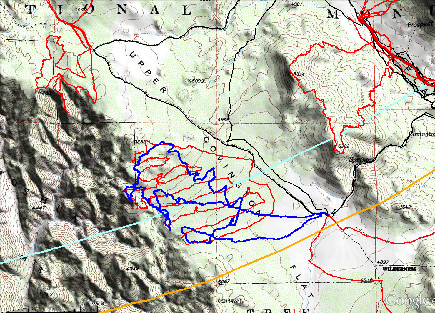
The track for JT64 is shown in dark blue. Original search tracks are in black, and tracks since then in red. The light blue line is the 10.6 mile Serin cell tower radius and the orange line is the 11.1 mile radius.