Note from Tom: This search marks a significant milestone in the ongoing search for Bill. The original search effort in June and July of 2010 produced a little over 770 “ground searcher miles” of recorded GPS tracks. The search efforts since that time, almost all unofficial and now totaling almost 780 recorded GPS miles, have now exceeded the original search. So in effect, the original, rather substantial search effort has been doubled. Personally, I’m not aware of any other lost person cases where this has occurred. Yet Bill still remains elusive. Report and photos by Adam Marsland.
Date: 5/31/2014
Participant: Adam Marsland
General search area: Northwest and southwest of Upper Covington Flat.
Rationale for searching this area:
Following up on slivers of cell coverage found on the 10.6 mile radius on JT 64 near a possible entry point to the area that might have skirted cell towers, attempting to clear the remaining unsearched areas between Upper Covington Flat Road and the steep cliffs to the west.
Impressions of area and findings:
The western boundary of the flat drops precipitously and dramatically. The terrain in the flat itself is lightly sloping and easy to navigate, with numerous Joshua and other trees.
Coverage level: Very good.
Comments:
Last week’s trip to the Upper Covington Flat area (JT 64) was to look into the possibility that Bill had become lost in the area west of Stubbe Springs, eventually emerging here by a roundabout route three days later. The trip revealed some surprising wisps of cell coverage, including one (smack on the 10.6 mile line) at the entrance to a wash leading into the area on a path that could have conceivably skirted cell towers up to that point. The pattern of cell reception relative to the topography and also its alignment to the cell splash to the immediate northwest which was searched on JT 33 made me believe that this cell reception was likely from the Serin tower, further south than previously thought feasible (Tom, it should be noted, is more dubious).
That aside, clearly it is at least possible that a cell ping might have occurred at numerous places in Upper Covington Flat near the 10.6 mile radius. However, after a careful look at Google Earth, Tom’s other objection to this theory is harder to explain away. Just as Tom had pointed out, the topography between Upper Covington Flat and Stubbe Springs is such that it is very, VERY hard to fathom Bill getting from his car to that particular wash, because all the washes (and the easiest means of travel) from both areas drain to the southwest, into Coachella Valley, and the traverses necessary to get Bill where he would need to be are such that it’s hard to understand why anyone, particularly a man hopelessly lost, would embark on them. There may be a topographically forgiving way to do it, and I plan to spend more quality time with a map once this report is written to follow up on some new ideas, but I have yet to find it. It’s possible. Anything’s possible at this point. But it isn’t, from what I can see, likely.
The other problem is that once in the area into which the wash emerges there’s steep cliffs to the west and a road (and then a trail) not far to the east extending north to south, encountering which one assumes Bill would find his way out….which leaves a small swath of land about a half mile to a mile wide between the high western cliff faces and the road and trail as a probable place to find Bill. This area was searched in JT 33, JT 48 and JT 64, leaving only a few areas left unchecked. I decided to take a trip out to the park today to hopefully clear these spots and eliminate Upper Covington Flat from consideration…a low probability area to be sure, but given how few places remain one that seemed to need to be ruled out.
I arrived at nearly 6 p.m. — late, but missing most of the summer heat — and parked (I assume) at the same spot Tom did in JT 48. The area immediately next to that wide spot in the road is obviously being used for some sort of research, and I moved through it quickly.
The most obvious other objection to Bill being here — that it would be unlikely for him to expire in the brush so close to a road — was quickly dispensed with, as even with a good map, rough familiarity with the area and a much better GPS fix than I am used to having, I still unwittingly came within 50 yards of the road four times. There were somewhat larger trees than were to be found in the area we’d searched last week to the south, and I paid special attention to ones that might provide good shelter to someone suffering from exposure. There are not as many as you might think, and as I’ve said before, it’s fairly easy to see if someone had been there. I approached one particularly promising candidate, and it was immediately apparent that it was a favorite resting place for a mountain lion or two. I moved on, quickly.

Potential sheltering tree turns out to be kitty lair.
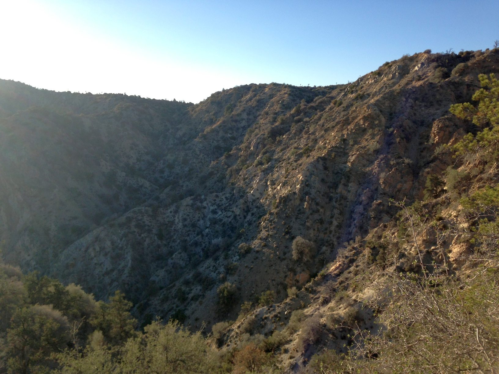
Most significantly, I was able to take a look from a different angle at the precipitous drop off to the west and further check to see if it was possible Bill had gone this way. I made my way down one wash that looked navigible as far as it went, then followed it further on a spine with steep, plummeting dropoffs on either side which extended out into the dramatically falling terrain, offering a great view. Once again I concluded that it was unfathomable that anybody, particularly a man who’d been out for three days without a walking stick, would try to go this way. The terrain was as spectacularly beautiful as it was brutal. With one proviso (see the last paragraph), I’m satisfied that the edges of these steep cliffs and canyons are the hard western limit for where to look for Bill.

A view of the terrain beyond the northwest edge of Upper Covington Flat.
Interestingly, I was not able to get a text out on the spine which extended out towards the Coachella Valley from the cliffside, but I was able to send and receive easily once I clambered up and back over the height of land, a repeat of the experience from last week where we were only able to get texts out on the opposite side of the summit from Palm Springs, but not out on the side facing the valley. You could see a lot of the valley from the place I got reception, so I was less sure that this was going to the Serin tower, but this spot was in a fairly direct line between the JT33 splash area and the places we got reception to the south on JT 64.
Taking advantage of a good GPS fix I was able to backtrack and check most of the remaining unsearched area, then crossed the road to look around a little. I knew Bill crossing the road was a long shot, but I had seen a footprint on the previous trip that looked about the right size and vintage for Bill, and it was on a direct trajectory from the wash to the low draw that would be headed in the general direction of Joshua Tree village. I just wanted to have a look on the other side of the road on this unlikely possibility. It was immediately obvious that this was a highly doubtful area, as there is a well beaten trail that runs parallel to the road (I believe the extension of the Riding and Hiking Trail). Still, there were a number of large trees between the trail and the road, and it was conceivable Bill could have laid down under one of them waiting for a car and passed, so I looked at as many of them as I could.
All I found were two truly humongous balloons. When people ask about the search for Bill, the same question comes up — would anything be left? What isn’t immediately obvious is how much anything that isn’t brown or green draws the eye, and even if Bill’s physical remains were gone, his pack, clothes and possessions should constitute a debris field at least six feet long. One of these balloons, which was about four feet in diameter in its ruined state, looked so conspicuous that it again reminded me that if you got anywhere near Bill, you should be able to see some trace of him somewhere.
When I got back to the car it was nearly dark, but I still had one more area I wanted to check, a small triangular sliver of land southwest of the parking area bounded by the JT 64 search area to the north, the Covington Crest trail to the south and east, and a low height of land to the west. This area was in the general 11.1 mile radius and also would be a potential route for Bill back to this car if he came out of the wash we found in JT 64. Although night was falling rapidly, I knew a flashlight might be just as useful in the dark because of how quickly it would be able to pick out contrast, and indeed I found more bones in the dark than I did in the light. They were all animal bones, though. The height of land area which was the western limit of my search was interesting, and I would have liked to have poked around further, but this was not the time.
Upon return to the car, I sat gazing at the map at the kiosk for awhile, pondering the geographic relationships to Bill’s car and it occurred to me that it might be possible, even with the limited amount of information we have, to re-sift the known facts and geography and by logical induction and profiling from Bill’s perspective arrive at some likely, specific scenarios for what happened — trying to deduce where he might have wound up by reconstructing his possible path(s) rather than back engineering from the likeliest ping sites. This may be a project I undertake. But for now I indulged myself in one of my very favorite activities: nighttime desert yoga under the stars. It was certainly possible that Bill could have pinged the tower from this area, but I didn’t see how he could have gotten here, and after today’s search I was fairly sure that he wasn’t here now. In my mind, Upper Covington Flats could be cleared…
…until, on the drive out, I had a rather startling thought: what if Bill had exited, not entered, the area in the wash we found on JT 64, pinging as he entered? With Coachella Valley in the distance, and what appeared to be a viable way down in the wash, it would be a defensible decision (by necessity he would have had to somehow miss the road and the easy way out, probably by hugging the height of land I’d looked at earlier)…and it would open up the entire huge rugged area to the west and south as a possibility resting place for Bill. Certainly, it’s much easier to get Bill topographically into the area south of Upper Covington Flats. However, it would require Bill traveling north into the JT 64 area without pinging a cell tower or encountering the Covington Crest trail on the way in, both of which are seemingly impossible. For the moment, it still seems this area is the hard western limit for this search. If a viable route can be found to get Bill to enter that wash and thence into the vast network of dry streams and steep precipices running down towards Desert Hot Springs, however, all bets are off.
GPS mileage submitted for this trip: 6.6 miles
Cumulative GPS mileage to date: 779.7 miles
GPS tracks for this trip in Google Earth kml format
GPS tracks for this trip in Garmin gdb format
GPS tracks for this trip in gpx format
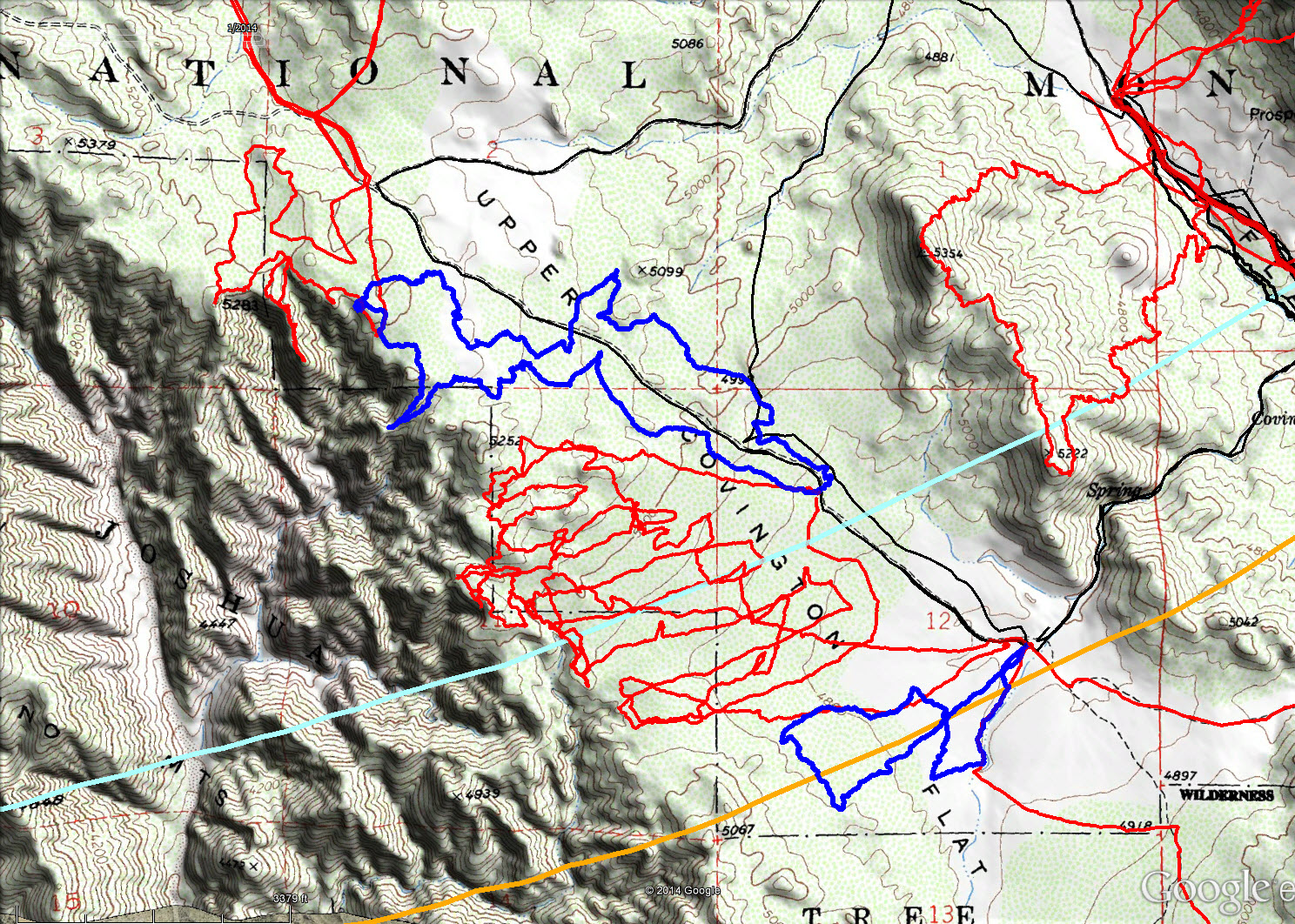
The tracks for JT65 are shown are dark blue. Original search tracks are in black, and tracks since then in red. The light blue line is the 10.6 mile Serin cell tower radius and the orange line is the 11.1 mile radius.
More of the terrain westerly of Upper Covington Flat.