Report and photo by Adam Marsland.
Date: December 26, 2014
Participant: Adam Marsland
General search area: Low mountains dividing Upper and Lower Covington Flat.
Rationale for search:
This is the last mostly unsearched area on the 10.6 mile radius.
Impressions of area and findings:
Rocky and steep in spots, but not difficult terrain; at least during daylight. There was a moment of cell phone reception on the west side of the ridgeline 10.66 miles from the Serin Drive cell tower, which adds this area to the list of possible places for Bill’s ping to have emanated from.
Coverage level:
Pretty good overall, but there is more ground cover than in other nearby areas.
Comments:
I had already planned to take one more look at this area (previously searched by me, with not much expectation of success, on JT61) as it is more or less the last largish area on the 10.6 mile line that hasn’t been looked at. Its proximity to two roads made it an unlikely place for Bill to be, but Ric Capucho from the San Jacinto Hiking Board made the rather (to me) startling suggestion that Bill might have actually made it to Lower or Upper Covington trailhead only to have nobody show up.
This is more plausible than it sounds, particularly for Upper Covington, which has been mostly deserted on my various visits there. Lower Covington sees more visitation, but given that it took rangers two days to find Bill’s car, Bill may have conceivably reached a trailhead expecting rescue and, not finding it, been forced to cast about for more options. It is a seven mile shadeless trek from Lower Covington to the nearest house (quite a bit longer from Upper Covington), and if Bill had been capable of that he should have simply been able to return to his car, so walking out on the road may not have been attractive. The mountain range to the southwest is significantly easier to scale than the north side of Smith Water Canyon that rises on the other side, so its proximity might have motivated a climb to get a cell call out.
This new idea also resonated with me because if you’re on the Riding and Hiking Trail, one of the most likely paths of travel for Bill, it seems fairly difficult to get lost. As I looked over possible scenarios to put Bill in Upper Covington when I was checking out that area, I kept reaching the conclusion that under most lost hiker scenarios, he should have wound up at Lower Covington.
At any rate, heavy traffic on I-10 put me at Lower Covington an hour later than planned, with the sun already low on the horizon. Nothing in my previous experience in the area had conditioned me to prepare for a very cold day, so I was underdressed for the very chilly weather, which would only worsen as night fell. I tried to hike a bushwhack route that put me between my JT61 path and the California Riding and Hiking Trail. The terrain was fairly rocky and while I kept my eye out for places Bill might have bivouacked, it wouldn’t have made sense for him to have come this way. I would expect him to stay closer to the trailhead and the trail. But I thought I should look around, anyway.
My destination was the high point of land overlooking the canyon running between Upper and Lower Covington, previously visited on JT61. On that trip I had gotten bars but no reception, so it was a plausible location for a fleeting ping, and also offered a good vista of the surrounding area. Assuming Bill might have ascended from the Riding and Hiking Trail where it joined the trail to Upper Covington, I looked for the easiest way up from there that didn’t duplicate my JT61 path. I found it steep in spots but probably doable for someone in a weakened but determined state. The area on the east side near the top is downright hospitable, with a lot of flat soft areas and large rock formations to hang out in.
Once on top, I started working my way back along the ridgeline, keeping to the west (Upper Covington) side both to not duplicate my JT61 path and because it seemed to offer the highest likelihood of pinging the Serin tower. And indeed, at that point a text did slip through to my phone, the first and only time I have gotten reception anywhere in this area. I was quite close to the 10.6 mile line when this happened, which was both pulse-quickening and exasperating since the sun had just gone down and I knew I had already covered the most obvious (read: easiest) route north on the ridgeline on JT61. Hopping around the top of a mountain in the dark in blistering cold with only a headlamp to search with wasn’t my idea of a good time, but I did my best to cover the areas on either side of my previous path. Headlamps are actually pretty good at picking out anomalies such as bones in the dark, but I didn’t find very much, and nothing to indicate Bill’s passage.
At a certain point I had to descend, and picked the spot that looked on the map to be the least treacherous. Maybe it was, but in the dark I didn’t enjoy it very much. It was steep and though the headlamp provided good illumination, you can’t scout your route very well. While gingerly picking my way down the steep slope I consoled myself by noting that I was adding to the search, but if Bill was in this area he obviously didn’t make it down, and that didn’t make me feel much better. I did eventually manage to make it back to the car without incident.
Tom recently indicated that the most recent cell phone information suggests that the 10.6 mile reading is more accurate than previously thought likely within a quarter mile of the 10.6 mile radius. Nearly all of the Smith Water reception areas lie closer to 11 miles. There just aren’t that many potential ping spots right at the 10.6 mile mark, and as Sherlock Holmes once said, “once you eliminate the impossible, whatever remains, however improbable, must be the truth,” which makes off-the-wall locations like today’s a bit less far-fetched.
At first it’s hard to fathom why Bill would be around here. So close as it is to two trailhead/roads, it would seem an unnecessary climb to nowhere. And now having been there, a backtrack from Lower Covington to this area can pretty much be ruled out. It’s not far, but it’s not close either, and it’s a fairly grueling climb. After looking over the landscape I don’t think Bill would have strayed too far from Lower Covington, and if he did, I would expect him to head towards civilization.
However, there is at least one scenario to put him in today’s search area that seems possible to me. A lot of things look plausible on a computer that don’t look good on the ground, and vice versa. If you’re tired and in a survival situation, you have to make hard choices based on your situation and your energy. The topo map shows a spring (unlike all the others in the area, not marked “dry”, though I am not aware there is actually water there) on the trail that leads westward from the California Riding and Hiking Trail at the mouth of Smith Water Canyon, a mile or so south of Lower Covington. If you are Bill, and you are heading north on the Riding and Hiking Trail and at that point are faced with the choice between going to Lower Covington or towards the chance of water, it is very possible he might have gone toward water, assuming he knew (from the map) or suspected there was a spring there. Once there, it is a very short distance to the Upper Covington trailhead. I find it very easy to believe that in the middle of July it might have seen no visitors for two days. After hanging out at Upper Covington for an indeterminate period of time, a logical next move would be to scale the nearest height of land — the place my phone got reception — to try to get a phone call out. It is very close to the trailhead and the easiest ascent is also at that point. You would have the option to proceed to Lower Covington from there while maintaining an excellent view of the area. All in all, assuming one is stuck at Upper Covington, it’s a logical spot to head to.
The original search records indicate a ranger checked the Lower and Upper Covington trailheads Sunday morning, June 26, possibly as soon as an hour after Bill’s phone pinged. If Bill pinged the tower from the ridgeline, he would have had a clear view of the whole Upper Covington area, but a descent would have been time-consuming and treacherous. It’s conceivable that Bill might have seen the vehicle on the road and got into trouble trying to get down to attract its attention. This is all of course pure speculation, but it does hang together logically and offers a plausible reason for him to be here.
If Bill did ascend this area, he would probably be found somewhere along the slopes of this small mountain range. Which doesn’t really thrill me, since I didn’t get a very a strong vibe that Bill had ever been here and searching the rocky west side, or the bushy AND rocky east side, would be time consuming and not much fun. But given there is a reasonable scenario to put him here, a fleeting reception at 10.6 miles, and with not too many other unsearched spots on that radius, this area is probably worth another more thorough look in daylight. Unfortunately.
GPS Mileage for this trip: 5.8 miles.
Cumulative GPS mileage to date: 834.4 miles
GPS tracks for this trip in Google Earth kml format
GPS tracks for this trip in Garmin gdb format
GPS tracks for this trip in gpx format
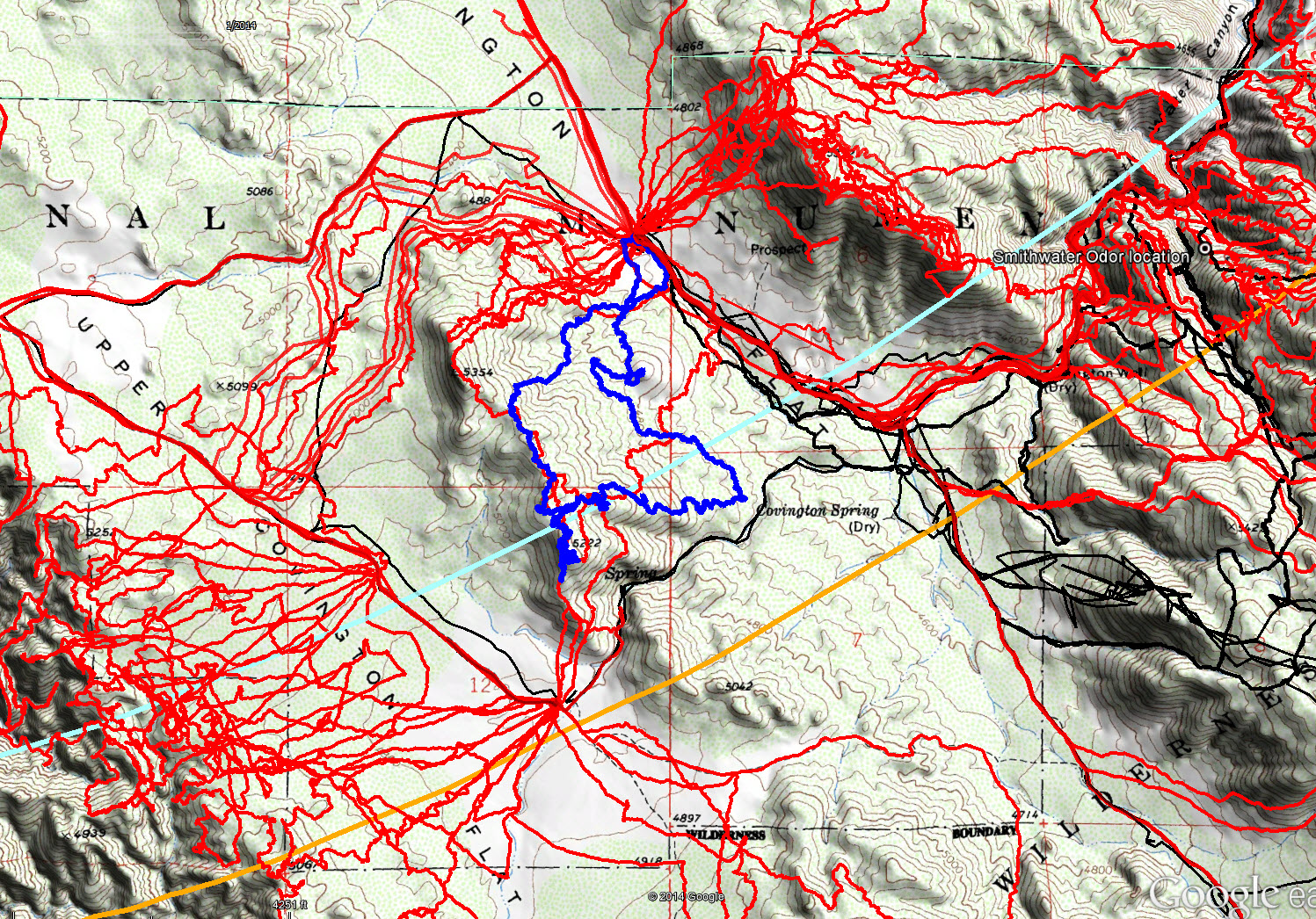
JT74 GPS tracks are shown in dark blue. Tracks from the original search are shown in black and searches since then are shown in red. The light blue line is the 10.6 mile radius from the Serin Drive cell tower and the orange line is the 11.1 mile radius.
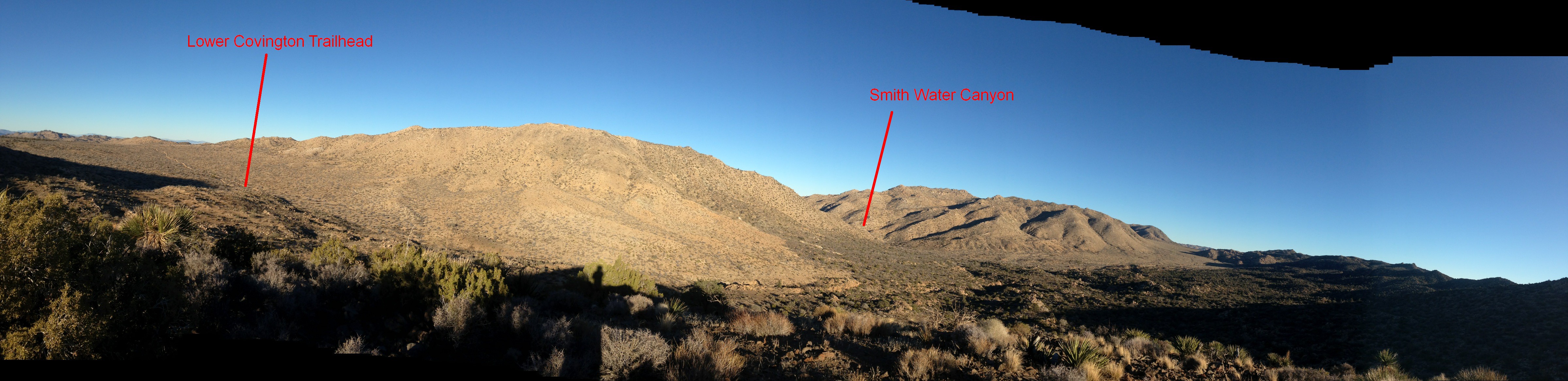
A panorama of the Lower Covington Flat area looking from roughly the north (on the left) to the southeast (on the right)