Date: April 18, 2017
Participants: Tom Mahood
General Search Area: The mouth of Smith Water Canyon along both the 10.5 and 10.6 mile Serin cell tower radius (Outbound on the 10.5 line and return on the 10.6 line) and the northerly slopes of Smith Water Canyon above the easterly Acacia grove.
Rationale for Search: A continuation of the search I began with JT86, examining the areas between the 10.5 and 10.6 mile radii from the Serin Drive cell tower. Also included the area on the northerly slopes above the easterly Acacia grove which I put forth as my best estimation of where Bill ended up in my post, “Ewasko Thoughts, May 2016“. Spoiler alert….I was wrong.
Impressions of Area and Findings: Extremely rugged terrain. Did. Not. Enjoy.
Coverage level: Mixed. While in many cases I had excellent sight lines to terrain below me, the large crop of grasses and wildflowers from this past winter’s rains obscured much of the ground, including snakes.
Comments:
As I mentioned in my JT86 writeup, I’ve been out of ideas for a while so I thought I’d just walk the Serin 10.5 and 10.6 radii and see what it looked like. The first part, which I did as JT86, was relatively mild terrain. The remaining segment that I wanted to do, in the middle Smith Water area, was anything BUT mild and I needed to wait until I was in much better shape to attempt it. Eventually I ran out of excuses and had to give it a shot.
It proved to be rather challenging. As it was high snake season I had to be very watchful of where I was stepping. However all the damn grass and wildflowers obscured a lot of the ground. Include in the mix the need to be watching my GPS and following the Serin radii lines, at the same time doing a slide slope traverse of rugged terrain using a hiking pole, I was sorta one hand short. Oh yeah, I also had to be looking for Bill. It was an high workload that made for slow going.
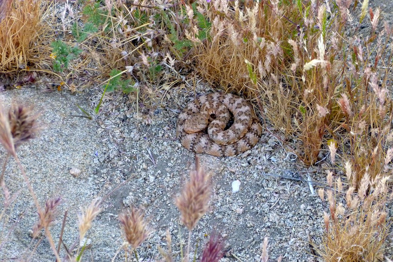
What appeared to be a small pile of dog poop in the shade…..upon closer inspection…..wasn’t. Yeah, it’s that time of year again.

Some of the wildflowers near Samuelson’s Rocks. Pretty, but they really compromised ground visibility.

Some of the wildflowers in the mouth of Smith Water Canyon.
Pretty quickly, on my outbound run along the 10.5 mile radius, I cliffed out. The terrain went vertical along the radius line and I had to climb higher up to continue, eventually getting up to 400 feet above the canyon bottom before I could proceed. I did have rather impressive views down to the canyon bottom and took lots of time to scan things.

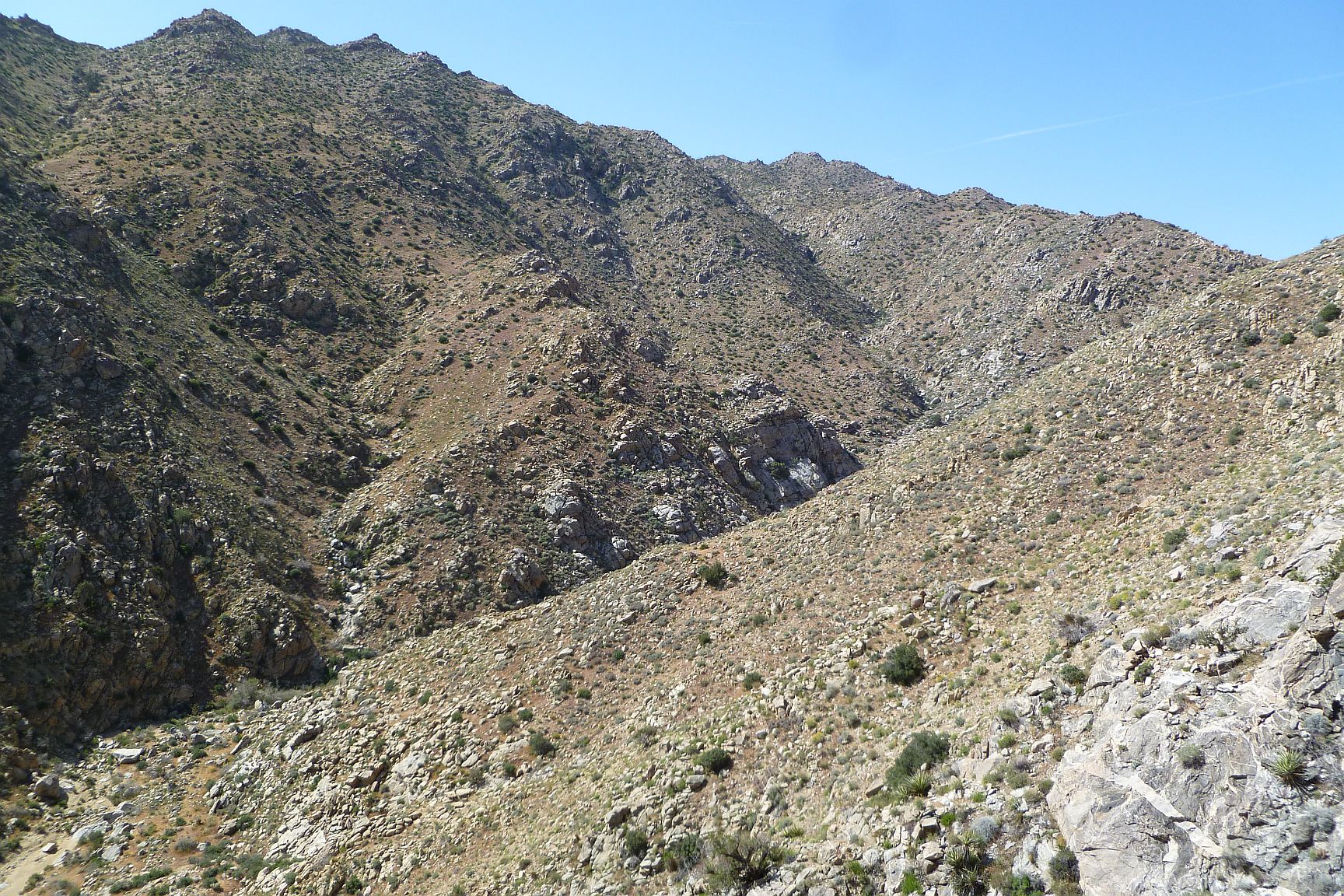
Looking back at the northerly slopes after finishing my traverse. This large chute and associated cliffs forced me to climb high to get across it. If Ewasko did a climb on the southerly slopes after passing the Acacias, it would have been the terrain in the left side of this image which I checked fairly well.
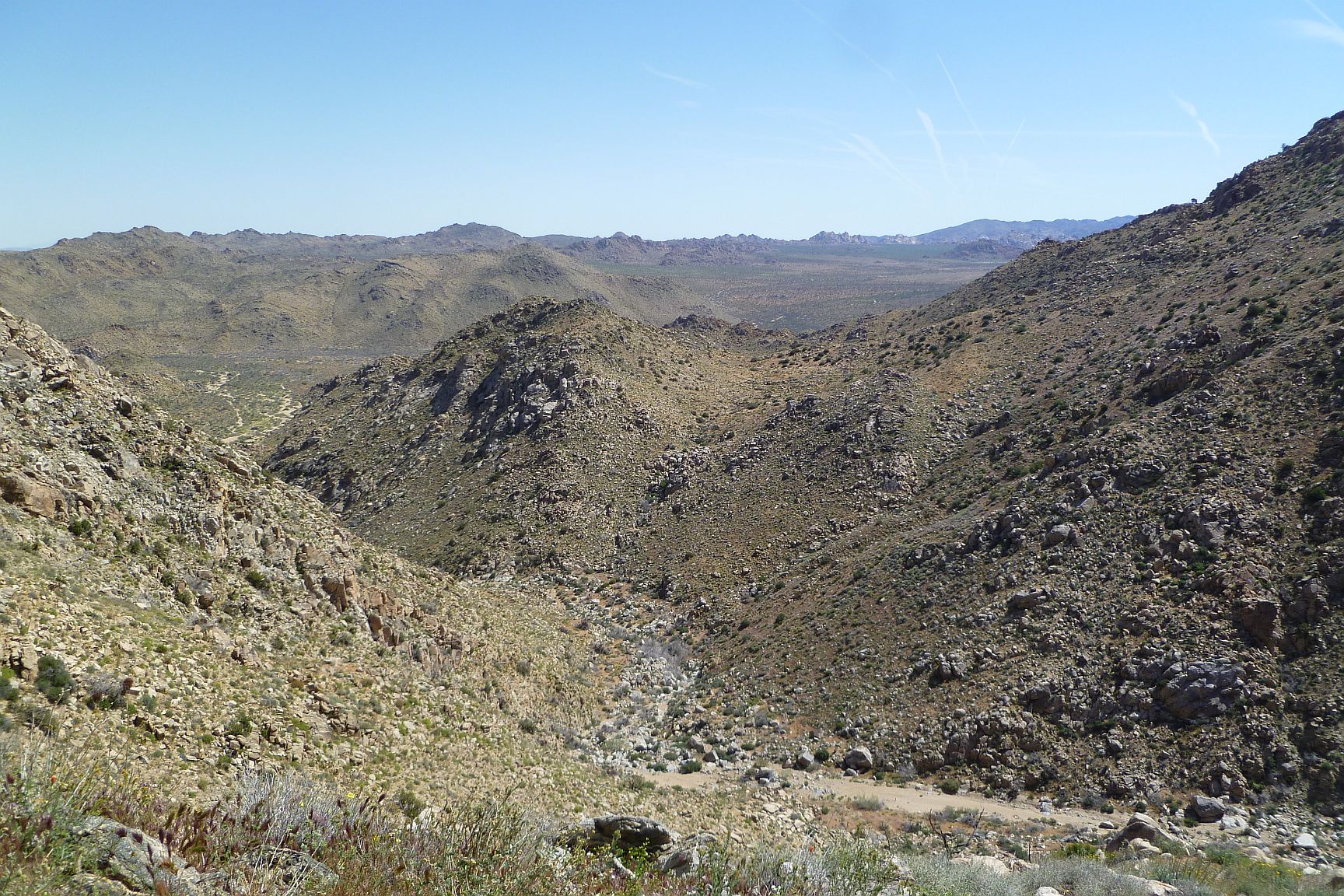
Looking easterly toward the mouth of Smith Water from up on the northerly canyon slopes. Samuelson’s Rocks can be seen in the distance, and even out to Park Road.
The southerly slopes of Smith Water. The easterly end of the easterly Acacia grove is just barely visible in the lower left of the image.
Reaching central Smith Water, probably my least favorite spot in all the world, I descended a bit and started back roughly along the 10.6 mile radius. This section was also directly above the easterly Acacia grove so I slowed down even more to check out all obvious nooks and crannies. This was one of those rare trips where it suddenly felt like I could come upon some clue to Bill at any moment and it really energized me. The Acacia grove below made sense and I could see possible climbing routes both below me and also on the opposite canyon slope.
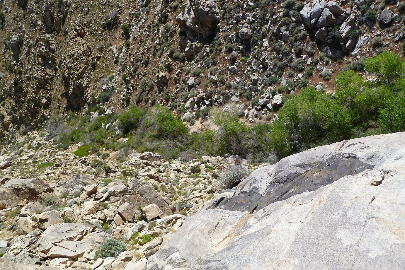
Looking down on the Acacia grove from above. The easterly end of the grove is towards the left in this picture. I postulated Ewasko did a climb from this area.
Unfortunately, as It has usually been for me, harsh reality destroys my beautiful theories. There wasn’t a trace of Bill on the southerly slopes. I had excellent vistas all the way down to the Acacias, and if Bill had made it up the southerly slopes his belongings would have migrated downhill leaving a debris field I would have had to have crossed.
I did study with binoculars a couple of potential climbing routes on the opposing, southerly slopes. They looked interesting enough that when I finished my traverse and made it back down to the canyon bottom, I climbed back up the southerly side to check them out. Again, nothing.

Yet another “Not Bill”.
So….At this point, I got nuttin’. I am completely out of reasonable ideas as to where to look further. My imagination has failed.
When I and my foolish cohorts first started this adventure, we pretty much dismissed the cell ping and focused on the area between the trailhead and Quail Mountain, where one would expect a missing hiker to be. Of course, no Bill.
The next change in thinking was to consider the cell ping, but clearly the distance couldn’t be correct, could it?, As a result we visited all areas of cell coverage the Serin tower splash maps revealed, even as far as 20 miles from the tower. Again, no Bill.
It was about the time we were wrapping up the outlying spots of cell coverage that we received information that the ping distance might actually be quite accurate, which strongly implied Smith Water Canyon. As weird as this would have seemed initially, it was starting to fit the facts, and part of the facts was knowing where Bill wasn’t. But a great many miles of searching in Smith Water have failed to turn up Bill.
I think this is due to one of two things….Either Bill crawled into a non-obvious shelter and we walked right by him, or he did something completely unexpected that never occurred to us and is somewhere else. Because animal activity would tend to scatter personal belongings even from within a shelter, I’m inclined to think it more likely the latter issue but I have no idea where that might be. I still am of the opinion that foul play or a staged disappearance, while possible, have such low probabilities that “we just didn’t look in the right place” remains much more probable.
Lacking any unexpected new ideas, I don’t foresee my making any further trips out looking for Bill. It’s just too sketchy an area to go into without some sort of a least faint hope of him being there. In the 68 trips I’ve personally made out there I managed to injure myself pretty good on two of them, because eventually, given enough chances I’m prone to do dumb-ass things. In both cases I was able to get myself out, but either incident could have been a rescue instance had the circumstances been just a little different. So yeah, lacking any good ideas I don’t think the risk/reward ratio is very good at this point. And it feels like I’m overdue to do something stupid. That said, if I had any new ideas that seemed worth a damn, I’d be out in Joshua Tree in a second.
It remains a maddening puzzle…..
GPS Mileage for this trip: 9.1 miles
Cumulative GPS mileage to date: 940.4 miles
GPS tracks for this trip in Google Earth kml format
GPS tracks for this trip in Garmin gdb format
GPS tracks for this trip in gpx format

JT88 GPS tracks are shown in dark blue. Tracks from the original search are shown in black and searches since then are shown in red. The light blue line is the 10.6 mile radius from the Serin Drive cell tower and the yellow line the 10.5 mile radius. The easterly Acacia grove is shown in green.