Date: 2/14/2013
Participants: Tom Mahood
General search area: The southerly slopes of the mouth of Smith Water Canyon and the adjacent southerly canyon rim, and area westerly of Quail Springs.
Rationale for searching this area:
Explained in way too much detail here: Current Bill Ewasko thoughts, January 2013.
Impressions of area and findings:
I think the area still holds some promise, but the unexplored areas are rapidly filling in with tracks.
Coverage level:
I moved rather slowly and carefully on this trip, more so better than usual. I’d estimate my coverage to be 80% within 75 feet of my travel path at a minimum, and in some areas a much wider swath. There weren’t any nooks and crannies along or near my route that weren’t checked.
Comments:
After Myth and company’s JT46 effort, I realized there was a significantly smaller area left to check. So I worked out a route to fill in the blanks, suitable for a solo trip. I also wanted to check an area beyond the 11.1 mile Serin Tower distance since I was going to be in the neighborhood. Finally, I was interested in having a look down the chute Patrick and I had spotted on our JT44 trip, when we reconnoitered the southerly slopes of Smith Water. I wouldn’t make the decision whether or not to descend until I actually saw the thing and assessed what it was like.
Climbing up past Quail Springs was pleasant but damn steep. A short distance to the west of Quail Springs, and well above it, the terrain flattens out considerably and becomes reasonable. Or maybe that was just a relative sensation. I don’t know, but it was an improvement. I’ve been in that area enough now to start recognizing landmarks from previous trips. While this in itself is sad, I realized that even though there are gaps on the map of GPS tracks, in many cases I could see over to previous paths.
I slowly worked up and westerly along my preplanned GPS route. I mentioned slowly, didn’t I? Yeah, it was taking a while. There were still a lots of snow patches in the shade, which made looking for anything non-earthtone difficult. But I finally got to my high point, a saddle along the edge of the canyon from which the descent began into Smith Water. Somewhere down below was the top of the chute, my immediate destination.
As I started down I was surprised how easy the descent was at this location. Steep, but open soil which allowed for easy sliding. If it were a jumbled boulder field it would have been different, but this was….OK.
I rather quickly reached the GPS point which marked the top of the chute I was interested in, and I cautiously peered down it. Yeah, it looked like a pretty bad descent but I couldn’t get a clear view of the whole thing. Then I moved just a little westerly and it was a different story. I was on a spine between the chute and another chute I had previously gone down. And the spine looked feasible.
I was faced with an interesting decision. If I returned the general way I came up, via Quail Springs, I’d have to make a substantial climb back up before I began a long, steep rocky descent. But I could see Smith Water Canyon right below and it looked so….close (Yeah, I know, this is where people get themselves into trouble). And I also knew there was a grove of meat eating bushes in the canyon below that I’d have to pass through on the way out of the canyon.
Ultimately gravity won out and I headed down. This was two pole terrain, so out came my second hiking pole for the descent. As I went down I traversed the spine between the two chutes, focusing on the one on my right. I was able to get right into it in several spots. It turned out the spine wasn’t too bad and there was again a lot of open soil. Someone with an injured leg could have possibly slid down it. By the time I reached the bottom I had completely cleared the chute and found nothing. From there it was a very long slog back to the vehicle.
It has been said that there is no sadder sight in the world than to see a beautiful theory killed by brutal fact. I think the idea that Bill’s in the southeast area of Smith Water is an extremely beautiful theory. It feels just right and every clue we have fits. But despite repeated trips into that area, and pretty good ground coverage, Bill eludes us. Are there still unchecked areas there? Sure, but we’ve covered a great portion of it, especially the obvious routes someone travelling cross country might have chosen.
I shall ponder on this problem a while.
GPS mileage for this trip: 11.3 miles
Cumulative GPS mileage to date: 653.2 miles
GPS tracks for this trip in Google Earth kml format
GPS tracks for this trip in Garmin gdb format
GPS tracks for this trip in gpx format

The overall track for JT47. Clockwise travel, with the climb near Quail Springs and the descent down the chute into Smith Water Canyon. Why do I keep coming up with these ideas??

A closer look at the SE Smith Water area. As usual, the blue line is my current track, black lines are the original search, red lines other searches since then, and the Serin 10.6 and 11.1 mile radii in green dash and purple dot, respectively.

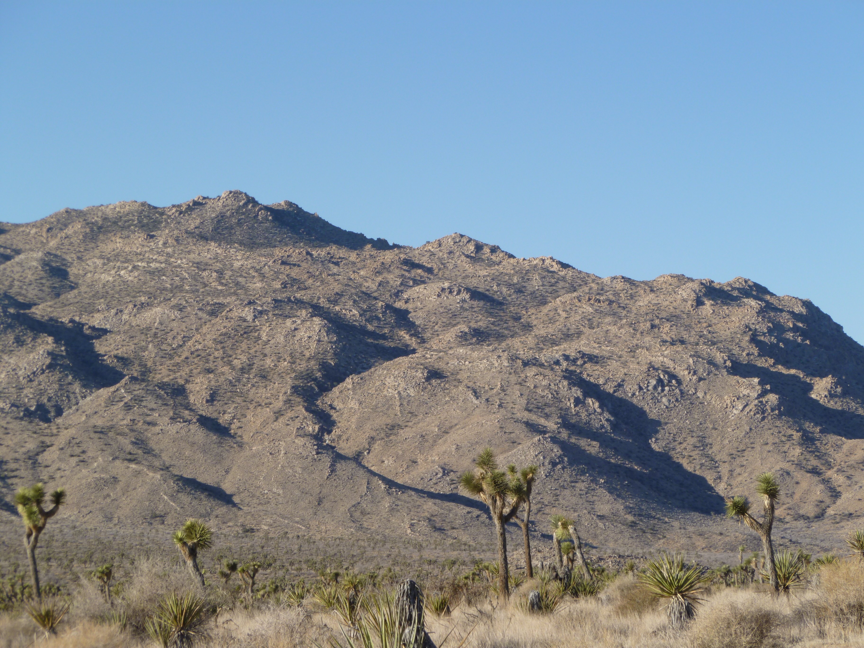
Looking westerly towards the day’s fun, on the way in.
Click on this picture for a REAL BIG image of the JT47 search area. Bigger than you need.

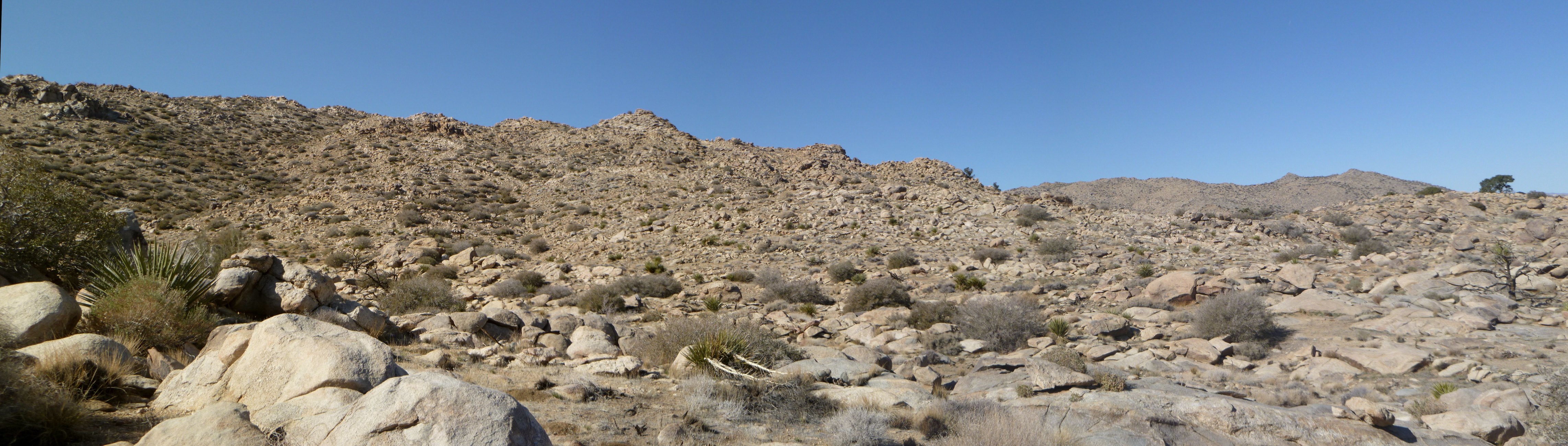
A view looking westerly the planned climb out of the flats into the search area. Quail Springs, which is dry, is at the bottom center of the bowl.
Typical terrain of the upper area before the drop off into Smith Water. The drop begins just to the left to the far right tree. The terrain up here isn’t too bad at all….once you get here.

Looking down the chute into Smith Water. Those who have been in the canyon will recognize the dry waterfall and the meat eating bushes off on the left side of the picture.
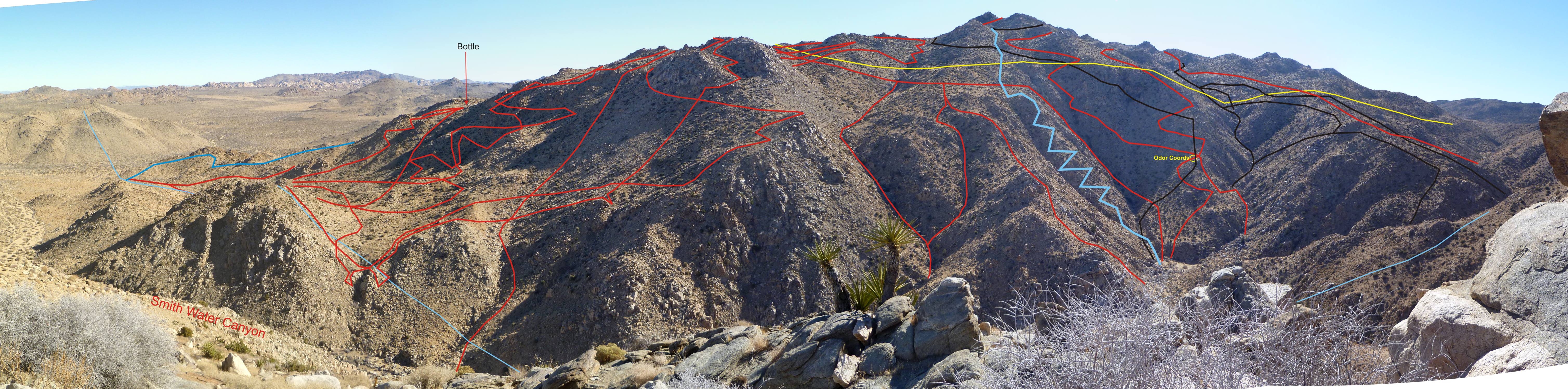
The image of the southerly slopes of Smith Water Canyon updated. The light blue line is my descent down the chute for JT47. Red lines are previous search tracks and the black lines are from the original search. The yellow line is the 11.1 mile Serin tower radius and the very light blue line is the 10.6 mile radius.