Report and photos by Adam Marsland.
Date: 6/17/2014
Participants: Adam Marsland, Donna Villareal
General search area: Washes and high ridgelines to the west of the crest line near Upper Covington Flat, also immediate area southeast of Upper Covington Flat.
Rationale for searching this area:
Searching for potential western exit points out of the primary search area following discovery of potential cell ping site west of Upper Covington Flat; also checking out previously unsearched area suggested by a poster on Mt. San Jacinto message board.
Summary:
After my previous trips to the area, I had evolved a new theory for what happened to Bill revolving around the patterns of cell reception in the area, and in the region, that would place him on the western edge of Covington Flat.
(I don’t want to waste Tom’s bandwidth detailing the ins and outs of this theory, but I have posted my ideas, the reasoning behind them, and how they’ve changed after this visit on my website here. I will continue to update this page as my thoughts on the case evolve)
The topography here falls away steeply and at the suspected cell ping site there is a wash that seemingly offers the only navigable pathway out of the area and would eventually (9.5 miles later) have taken Bill to civilization (after a fashion) in the hamlet of Sky Valley. My primary goal was to search this wash with the idea that Bill may have attempted to walk out to visible civilization by this route. Secondarily, I wanted to have a look at a spot suggested by a poster on the San Jacinto Hiking Board. I considered the latter a low probability area, but it hadn’t been looked at and it was fairly easy to get to.
The terrain west of Covington Flat is gorgeous and brutal. Trying to trek through this area would take considerable back country experience and not a little nerve. The wash in question was passable, barely, but it is hard to imagine a man weakened from sunstroke and thirst, and probably injured, getting through it. It is possible, however, to hop washes to somewhat level high ridgelines that project outward westerly into this area. This route can be followed without too much difficulty for awhile, and we found evidence that someone had tried to do just that….however, the terrain drops away precipitously and the descent from these ridgelines, while possible, would be daunting and probably disastrous in the invisible lower regions.
The remainder of the area (Upper Covington Flat) is comparatively benign with small trees dotting the easily traversible landscape. Not to mention a prodigious amount of wayward balloons.
Coverage Level:
In the washes, pretty much 100%. Excellent in all other areas. This search also continued to fill in the blanks around this suspecting ping area from previous searches in JT48, JT64 and JT65.
Comments:
I started looking at this area originally because one thing I have learned in investigating static things like old roads is that if you are looking for something and you can’t find it, it usually isn’t because there is no trace; it’s because you’re looking in the wrong place. After my little mental thunderbolt driving away from Upper Covington at the end of JT65, I returned home and pored over Tom’s site one more time. Tom also helpfully sent a Google Earth overlay of the Verizon cell reception. Very quickly a new theory began to take hold that, for me at least, had the ring of truth and the more I thought about it, the more it hung together.
I detailed (and after this trip, in some cases rebutted) the finer points of this theory in the web page I linked to above but it basically rests on the interesting fact that there is a route that would take Bill all the way from Juniper Flats Road to the suspected cell ping site found in JT64 which would not touch a cell tower and only cross one trail, at the very end (most impaired) part of the journey. Moreover, the first two-thirds of this route made a heck of a lot of sense topographically, particularly if Bill attempted a loop back to his car via Stubbe Springs, got off the trail and was injured. That meant that the wash I observed in JT65 was a potential exit point from the primary search area and opened up the entire rugged, unsearched terrain to the west of Upper Covington Flat as a potential area to look for Bill.
My aim was to follow the wash as far down as I could go safely. From Google Earth I could see that it gradually joined other washes to form a wide canyon that wound its way to empty at the small hamlet of Sky Valley. Since this was a mostly unexplored area where no one ever really goes, I waited until I could draft a friend to come with me in case we encountered difficulty.
We were extremely fortunate with the weather, which was about 15 degrees cooler than normal for this time of year. While hot in direct sunlight, there was a lot of strong wind to keep us cool though it was a bit challenging for my friend, who though an avid hiker was unused to the desert climate. For myself, it was nice to see how much I’d regained my energy and stamina in the past two months, when I made my first groggy and flabby visit to this area after a long road trip.
At any rate, we arrived at the trailhead about 11 a.m. and walked to the area I had previously visited in JT64 via an offset from Covington Crest Trail; I wanted to cover previously unsearched ground and also simulate the path I speculated Bill had taken through the area, and look at the possibility that Bill could have missed the trail when he crossed it (the most glaring problem with my theory). My immediate answer was that I could conceive of it if Bill was impaired and in a low light sun-in-eyes situation (both of which are highly likely), but it would be vanishingly unlikely otherwise.
On the way to the place we had gotten reception in JT64 I monitored my Verizon phone for service. About halfway there, we supposedly crossed into Verizon’s coverage zone (which would be the first such opportunity on my proposed track for Bill), but the phone vaccillated between mostly “no service” and occasionally one ineffectual bar that did not actually provide any reception. Once we got to the immediate area we had gotten a text out previously, however, the phone instantly lit up with texts and e-mails. One minute later, we could not get a message out, and we lost reception after only moving a few yards or so. This spot is almost exactly 10.6 miles from Serin tower, and is in a low depression area. In other words, this exactly duplicated our experience from JT64 and fits the odd characteristics of Bill’s cell ping exactly: one specific spot, surrounded by dead zones, with strong but transitory reception. 10.6 miles from Serin tower, and just downwind and in line from a known spot of coverage, out of sight of the valley below.
This confirmed Bill could indeed have walked the 15+ miles from his car to this spot without ever hitting a cell tower, pinged for 10 seconds, and moved on. Given the timeline and chracteristics of this very odd clue, I was more convinced than ever that this was the right spot.
The second part of the theory, however, the escape through the wash, quickly was ruled out. Parts of the wash were very easy going but other parts were choked with rocks and deadfall and while we could get through it with difficulty, it was hard to imagine an injured or incapacitated hiker ever making it, and we bailed after only going a half a mile or so.
What WAS conceivable, however, was someone trying to make it down the wash, failing and then making their way through paths of least resistance to the next wash over and thence to some high ridgelines that extended west jutting out over the rapidly plunging topography, and we found old, indistinct (but definite) footprint evidence that somebody, at some time, had done exactly this. I was able to make my way for a reasonable distance following these ridgelines, and a sufficiently motivated person could have made it further than I did. The flatness of the terrain on these ridgelines extending out over the abyss, however, meant that the eventual dropoffs at the end of them had to be twice as high, and given the plunging terrain I shuddered to think of what would happen to anybody who tried to get out this way.
Likewise, it was conceivable that someone, even an injured person, might have made their way down the slopes of these ridgelines to meet the washes I and at least one other person in the past had tried to follow further down. These slopes were steep, but unobstructed. But again, I could only imagine that some very deadly terrain lay just out of sight at the bottom. If someone — perhaps Bill — had tried to go this way, it would be an extremely nervy and desperate thing to do. As relatively easy as these ridgelines were to traverse, eventually they would have to go down, and I could only imagine how ugly the eventual drop to the surrounding land level would be. Regardless, while I could see someone had come from the wash up to this area, I did not see any evidence that they had gone any further than I did.
Having gone as far west as I was prepared to go without highly skilled backcountry hikers to act as backup, I did a fairly thorough search of the ridgelines and washes in the area, and then we also attempted to fill in places around the suspected ping area that might have been missed on previous searches. We did find five large vertebrae scattered in a wash in this vicinity. They looked large enough to be human, but Tom and google both suggested that they probably weren’t. Regardless, we found no other bones or debris in the immediate surroundings.
I was very frustrated. I still felt like this was where Bill’s phone pinged. But unless those footprints were Bill’s (and good luck ever finding him if they were), I couldn’t fathom where he would have gone. With a road (invisible from this point) less than a mile to the east and the steep cascading topography of the crest to the west, there wasn’t much room for Bill to be, and the immediate area had been searched at this point as much as most of Smith Water. For the moment, it was time to go back to the car and gather our wits.
There was still plenty of time left, and we weren’t totally out of energy, so after a brief period enjoying the car’s A/C we decided to check out a spot not far from Upper Covington trailhead that Ric Capucho, a poster on the San Jacinto Outdoor Recreation Forum, had suggested where Bill might be found. I couldn’t recall Ric’s reasoning but it was an easy enough place to get to and it gave me a chance to look over the topography and also kick the tires of another weak spot in my theory: namely, why did Bill trek up to Upper Covington Flat when he was (if I’m right) injured and in the next canyon over?
On the way to the area, we encountered something interesting: many long strips of fabric that, on further inspection, appeared to be the remains of a small backpack, completely decomposed except for the seams and the zippers. This was still close enough to the trailhead (probably about a half mile) that it probably wasn’t relevant, but it was important in that as I’ve looked for Bill, I’ve kept a sharp eye out for his pack, which seems to me the biggest object that might still remain. This is the first time I’ve ever actually found one (or something that might have been one), and I was surprised to see how little was left of it.
A couple of things became obvious when we got to the low rocky ridges southeast of Upper Covington trailhead. One is that the path I had posited for Bill to come into this area by was impossible for an injured person and made no topographic sense, as it crossed some low lying rocky areas. He could have come through this region, but the entry point would have been further south, which theoretically would have pinged a Verizon tower, though I had the same experience here as elsewhere: mostly no service, with occasionally one bar that didn’t actually amount to any reception.
Another thing I discovered was that Upper Covington Flat road was fairly easy to see from this vantage point (it’s virtually invisible from any point west), so if Bill got here, one would assume he would head for the road and that would be that. Lastly, if Bill had come to Upper Covington Flat to get a cell call out, it would have made more sense to stay up in these highlands, which was easy and close compared to where we had just come from. So we took a good look around this small area. It was only after we got home that I was able to check the actual spot against the cell phone radius, and it falls short of the 11.1 mile mark.
In terms of actually hitting the target of what I wanted to search, this was probably my most successful trip to Joshua Tree. It’s also the most frustrating, because my basic theory made even more sense to me than before, and yet having searched the likely places, I could not fathom where Bill might have gone. Were those Bill’s footprints in the high ridges, or just some random hiker looking for a spectacular view? More likely the latter, but I could not rule out the former, especially as those prints were following the same topographical logic we were: trying to find an easy way down.
The other thing that bugged me, particularly as I got home: why would Bill come to Upper Covington in the first place? My first idea was to get a cell call out, but as I’d said, it wouldn’t make sense for him to cross the whole flat to get to the spot where I think he pinged. He should have just stayed in the highlands, found the road, and waited for help or walked out. Also, coming up further to the south, he would have to come up a much steeper area than the wash he’d been in, and if he could make it up that, why didn’t he just turn the opposite direction, with less challenging terrain, and go back to his car?
When I was organizing my thoughts and theories and writing them down on the webpage, I realized that there are certain things we can extrapolate as almost certainties for what happened to Bill. One is that he was injured — because if not, he should have easily been able to walk back to his car in the time allotted, no matter where he was. Another is that he must have left an established trail at some point. After mulling this over I realized there is a third one: that whether Bill was on the south side of Smith Water Canyon or the western edge of Upper Covington Flat (and I can’t think of a third potential cell ping spot that makes any topographic sense whatsoever, except perhaps Quail Spring), there was something that was more pressing and important to him than getting back to his car, because to be on the 10.6 mile line he had to be traveling away from it. After two or three days in the wild – it would seem that that what was most pressing to him was calling for help…and finding water. And of the two, water might have been the most important of all, since it would enable him to stay alive and wait for help indefinitely. So it occurred to me that I should revisit the whole idea in terms of a search for water (which, it should be noted, was part of Tom’s rationale for placing Bill in SWC, though my thinking is that his situation was probably not desperate enough at that point to warrant Bill making the detour).
Looking over the topography of the wash south of Lower Covington that I believe Bill came up (and which is a cell tower dead zone the whole way), there is a point where Bill would have been confronted by some rough terrain no matter which way he went. To the right would be the easiest terrain, and that would lead back to his car. To the center and to the left would be washes draining down from Lower and Upper Covington Flats, respectively. Which way would Bill go? It occurred to me that Bill would know only one thing with certainty: that it was a long, long distance back to his car and there was no water or cell reception the whole way. Given Bill’s long-term survival depended on water, it’s possible Bill may have decided to gamble on going up hoping to find water in the near term and perhaps a call out rather than making a trek of a finite known distance he had a concrete sense of and thought he wouldn’t survive. The wash that leads to Upper Covington appears to be gorge-like and may have given the illusion of water. And once committed to that path, it makes sense Bill would have kept going up to the high ground. That may explain a trip to Upper Covington. It should have put him in a cell coverage area, but given my experience in the region, I’m dubious about that, and he certainly would not have had his phone on the whole time, anyway. (The same logic, it should be added, would apply to Quail Spring if Bill was in Smith Water after all, particularly if Bill had a map on him)
Even though it has suffered a few self-inflicted blows from this trip, this theory still rings true intuitively, and more to the point, it gives Bill much more space to rattle around in for three days than the comparatively small, boxed-in cell phone dead area between Quail Mountain and Smith Water. It also gives us the “magic ping spot” at 10.6 miles where Bill can hit the tower and then immediately disappear, whereas in Smith Water, once you hit a coverage area you tend to find another fairly close by. (We did hit one more strong spot of coverage, in one of the washes, for a moment. My companion observed the cell coverage seemed to follow wind currents)
I like this theory. It still feels right in my gut. While I wouldn’t die of shock if Tom finally uncovered Bill in SWC (particularly if it was in the area above Quail Spring) I think there’s a good probability it is at least partially right. And yet after this trip, I don’t have the faintest idea where he went, or where he would be found. To quote the estimable Tom Mahood, I need to think.
GPS Mileage for this trip: 9.6 miles
Cumulative GPS mileage to date: 789.3 miles
GPS tracks for this trip in Google Earth kml format
GPS tracks for this trip in Garmin gdb format
GPS tracks for this trip in gpx format
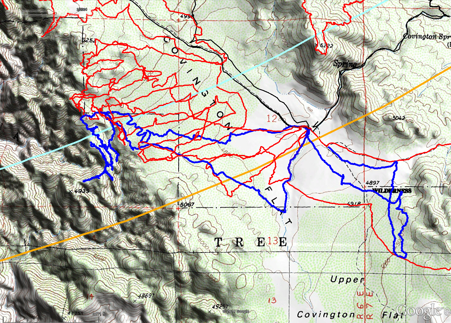
The tracks for JT66 are shown are dark blue. Original search tracks are in black, and tracks since then in red. The light blue line is the 10.6 mile Serin cell tower radius and the orange line is the 11.1 mile radius.
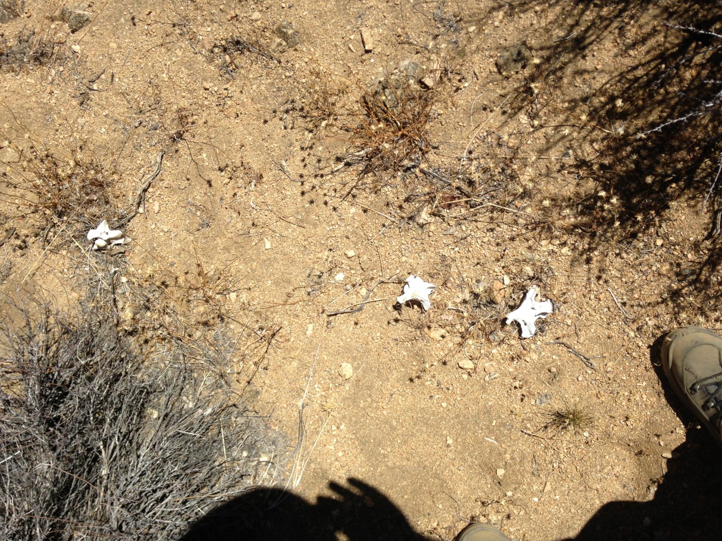
Typical animal bones found throughout the area.

Remains of a pack, or something like a pack, found not far from the Upper Covington Flats trailhead.