Report and photo by Adam Marsland.
Date: Oct. 25, 2014
Participant: Adam Marsland
General search area: Comprehensive search of the southern half of Upper Covington Flat.
Rationale for searching this area:
Scouting terrain and cell coverage to test the hypothesis that Bill may have entered Upper Covington Flat and pinged Serin Tower at a point first identified in JT64, as well as filling in gaps in the search of the area around that point.
Impressions of Area And Findings:
There is only one plausible route for Bill to enter Upper Covington and not see the nearby road to the trailhead. Taking that route, he still would be able to see Eureka Peak Road in the far distance, but not once entering the flat. The terrain and bearing towards where the road had been seen would push him in the direction of the ping zone first observed in JT64, at an angle where he may not have noticed crossing Covington Crest Trail. The patterns of cell reception noted at the southern end of Upper Covington also tend to support the theory that the cell reception zone observed in JT64 is from Serin.
Coverage Level:
Excellent at the beginning and end; the middle of the hike was more for reconnaissance but I kept my eyes open for signs of human passage.
Comments:
I felt I needed one more day to answer all my remaining questions about Upper Covington Flat and whether it was plausible that Bill might have come this way. Today was a good day to do it, and to make sure I had ample time, I drove to Yucca Valley the night before and spent the night, hitting the trail shortly before noon for what turned out to be an epic seven hour hike. I was feeling slightly ill and I had plenty of time, which meant I moved slow and kept my eyes open.
My first order of business was to pick up where I left off scouting the ridgelines of the western edge of Upper Covington Flat to the south of where I had left off on JT70; though this is well south of the maximum range for the ping, my thinking has been turning towards where Bill might have proceeded after pinging the tower, since the possible ping sites themselves have been fairly well searched. South was the only direction that hadn’t been looked at, so I had been pushing my way south. I also kept my eye open for possible exit routes to the wild areas to the west, and I was surprised to find a very long and fairly level height of land jutting rather far to the west from the southern end of the flat. I hiked as far as I easily could, which was quite a long way, and I could see the wide wash I had once thought of as a possible exit route to Coachella Valley fairly close below. I think a ridgeline descent from this point to the canyon might be feasible, though I had no interest in trying it. The view from this spot was panoramic and spectacular.
I could easily get a text out from this spot and indeed, every spot of reception (I found three, though this was the only consistent one) fit a pattern that I have seen on my previous trips to this area; the further west and south you go from the flat itself, the more likely you are to get signal — which is logical if the reception was coming from the valley below. The cell reception spots to the north found in JT64 do not fit this pattern, and I am about 99% sure at this point those spots are pinging Serin Tower. Whether Bill’s ping eminated from there is another question. But having now tracked the patterns of cell reception all the way to the bottom of Upper Covington Flat I have no doubt that it could have.
Working my way south the next question (besides looking for Bill) was if there was any way to continue down the ridgelines without encountering, or noticing, Covington Crest Trail. The answer to that is: no way. I came out almost bang at the end of the trail, and it was totally obvious, much more so than further north. The trail extends right out to the edge of the flat, no way around it. I could believe Bill could miss the trail once on the way in, but not twice on the way out too. So this would be the hard southern limit of where to look for Bill if he indeed ever came this way…which I doubt.
From this point, I struck out towards the southern part of the flat, and then coming up the higher terrain on the other side to take a look at possible entry points into Upper Covington from below/to the east and south. It soon became apparent that there was only one plausible entry for Bill to enter Upper Covington, and this was through the draw I looked at on JT70, and then through a low area just to the south of my JT70 route (which I went up, and then back down, today). The reason for this is that, besides it being by far the easiest route, this is the only place on the east side of Upper Covington from which the road to Upper Covington Trailhead, which is only a mile or two a way, cannot be seen. It’s plain as day everywhere else on the east side of the flat (and invisible from any other point in the area). Even so, as I took this route down into the flat, I noted that although the nearby road to the trailhead was invisible, its northern extension to Eureka Peak could still be seen in the far distance, though I suppose someone with a mild visual impairment might miss it.
This, however, gave me the first plausible reason for Bill to cross the flat, because the Eureka Peak Road disappears completely once you get into the flat itself. On seeing it Bill would, of course, have noted the direction, but there’d be no way to mark it once it vanished other than taking a compass bearing. I allowed myself to follow the easiest way down from that point and noted that, sure enough, that direction both went in the general direction of where the road had been seen (north, though slightly northwest of the correct bearing, which would have been more difficult to traverse), and more or less on a direct course to the area where the cell reception observed in JT64 originated. Bingo.
The old cart road that goes to the south edge of the flat (marked on USGS maps) that I had observed with difficulty last time was invisible to me at whatever point I crossed it, and this heading also crossed Covington Crest Trail perpendicular and running parallel to a nearby wash — the highest probability spot to miss it. If he did miss the trail, then the easiest straight line route would continue to nudge him towards the higher ground on the west side of the flat to the JT64 ping area — and the highlands would be attractive because they are much windier (and thus cooler) than the flat below. The whole trek was surprisingly quick and easy, and would have likely been doable for an injured man. As evidence that I was staying observant, along the way I spotted a small odd thing under a tree about thirty feet away and went to investigate — and it was half of another one of those weird silver balls I’ve been finding in this area! I have no idea what these are, but they sure have been deposited in some random places. In the same area, I found some larger than usual bones, but they appeared animal in nature and there was nothing nearby to indicate a human had been there.
Upon arriving at the proximity to where the cell ping might have originated, I decided to use what was left of my light to do a grid search. I was aware there was a small patch to the south that I had missed and it bugged me, and I also knew this was probably the last good look this area was going to get. The only unusual thing I noticed this time was that there were a lot of sheltering trees that showed signs of having been cleared out and sat/lain under. There were animal tracks nearby, and the number of them was such they couldn’t have all been created by Bill, but I could not rule it out either. This is one thing that has always bugged me about this case — Bill was out three nights and it is fairly easy to see if someone or something has scraped out a bivouac. The number of such spots in this area was unusual.
So, to sum up — It all fit. I had proved to my own satisfaction that the spot discovered in JT64 could have been the source of Bill’s ping. I had found a plausible entry point to Upper Covington Flat, and even more importantly, a plausible reason for him to go to the JT64 ping location: traveling north to try to intersect Eureka Flat Road which he would have observed in the distance (with that and the nearer Upper Covington Road remaining resolutely invisible his entire route from that point on, he’d have to dead reckon it). There were even plausible bivouac sites at both the JT64 ping site and also in the highlands where the draw entered the east side of the flat. And he could have come all the way from his car to this area without ever pinging a cell tower once, easily. Yes, the multiple visits to Upper Covington had proved to me that it was totally plausible Bill had come this way and pinged the tower from the site observed in JT64.
And having done the field work and demonstrated my theory holds water, I don’t believe a word of it.
Possible though it may be — is — I do not think Bill was ever in Upper Covington.
There are three reasons why.
1. He isn’t anywhere near the ping spot! After today, I can definitely say that the proximate area has been cleared. There are only two spots, maybe about thirty feet in total, that I can think of that I haven’t looked at, and Tom’s been around here too. I’ve had a look at the most probable routes south and he isn’t there, and it’s not a logical direction for him to go. The canyons to the west would be suicidal and the entries treacherous. The direction it makes sense for Bill to have gone is further north, towards Eureka Flat Road, but I’ve looked up there and so has Tom. If he IS around here somewhere, that’s where he probably is. But there isn’t enough uncovered ground that way to make me want to go take another look.
2. If Bill came this way I must have virtually walked in his footsteps crossing the flat today, and other than that kooky silver ball, I saw no signs of human passage, no footprints, refuse, nothing. He should have spent at least one night along this route. Along that route, plainly visible, up on the east side of Upper Covington there is an absolutely PERFECT rock formation for sheltering a sleeping man — it could not have been laid out better. I had a real sharp look at it, and at the area around it. I saw no trace of any human having been there.
3. For Bill to have come into Upper Covington, unless he went over some pretty rugged terrain for no logical reason, he must have come up the draw I explored today and on JT70, and that requires him to come up from Lower Covington Flat itself, NOT from the canyons south of Lower Covington, which I had theorized had been a bushwhack route and in which there is a place where Bill could have taken a wrong fork. I will definitely be taking one more look at the maps to confirm this, and it’s true he could have turned up this draw from the south without hitting the Riding and Hiking Trail (barely), but why on earth would he if he’s already arrived at Lower Covington and easy terrain? The route up the draw IS totally doable from what I can see…but logic dictates he’d stick to Lower Covington. Since there’s, like, a trail and a road and all there. Even if he did come from the south, stopping just short of the trail and the road beyond to head west up the draw, he’d have fought his way up some nasty terrain to get to that point. Why would you abandon the easy ground of Lower Covington to climb up some more washes? There may be a reason, granted — but I can’t imagine what it would be. Looking for water? Maybe. That’s about the only possibility that makes sense to me.
So, where’s Bill?
I think at this point there’s one plausible area left, and that’s the area extending due south of Quail Spring (which makes me feel somewhat better about accidentally blundering into that vicinity on JT55). A missing piece of the puzzle (Ric Capucho jogged my memory about this idea, which I’d had early on and forgotten) may be that, according to Tom, there was a lone helicopter in the air around Quail Mountain Sunday morning, roughly four hours after the ping. This could have provided the impetus for Bill to backtrack from his location above Smith Water Canyon back toward Quail Mountain, to attract the attention of the helicopter. This area is rugged and has been more lightly searched than the area within the ping zone, and barring a trip up the canyon that forms the eastern boundary of this area, was only searched in the initial rescue operation by helicopter, and then not for several days afterwards, at which point Bill was probably dead. Also, frankly, there are no other plausible directions for Bill to go from the ping zone above Smith Water Canyon.
I think Bill has to be in the area south of Quail Spring and southeast of the Smith Water Canyon “ping zone”. And I think if he is, Tom will find him in short order.
If he’s not, well…something really, really weird happened.
GPS Mileage for this trip: 11.1 miles.
Cumulative GPS mileage to date: 824.21 miles
GPS tracks for this trip in Google Earth kml format
GPS tracks for this trip in Garmin gdb format
GPS tracks for this trip in gpx format

JT72 GPS tracks are shown in dark blue. Tracks from the original search are shown in black and searches since then are shown in red. The light blue line is the 10.6 mile radius from the Serin Drive cell tower and the orange line is the 11.1 mile radius.
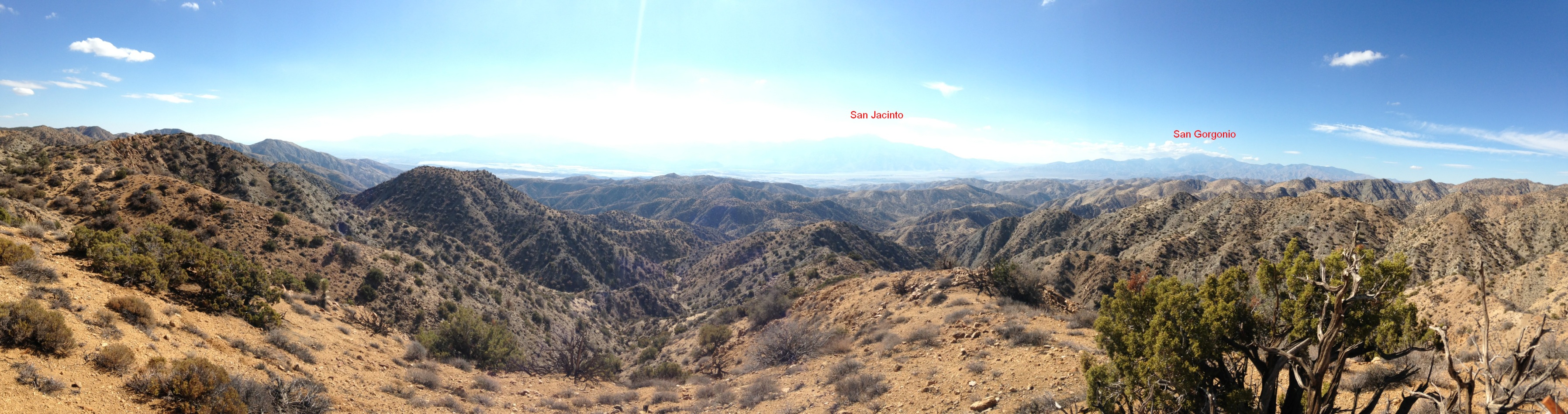
Panorama from height of land jutting west into the canyons from the southwest edge of Upper Covington Flat looking west and northwesterly.