Report and photos by Adam Marsland.
Participant: Adam Marsland
General search area: West southwest of Upper Covington Flat
Rationale for searching this area:
Filling in gaps in search of this general area.
Impressions of Area and Findings:
As with previous trips, the flat area is open ground interspersed with large bushes and small treas, and the canyon areas to the west are steep, yawning and nasty.
Coverage Level:
Good in the primary search area. Didn’t look so hard on the way in and out (this ground has been covered numerous times).
Comments:
As I did earlier this year, I capped a long and extremely grueling coast-to-coast road trip for my day job with a search for Bill, because that’s just how I roll. I stopped by Joshua Tree on the way home from Phoenix, my goal being to fill in the area (particularly the height of land) south of where both Tom and I have been searching, and proximate to an isolated spot of cell coverage that I believe (but Tom does not) originates from the Serin Tower, and lies exactly 10.6 miles from it. I also wanted to check and see if there were more plausible entries to the wild canyon areas to the west south of where we’ve already looked.
The terrain that didn’t involve trying to descend into canyons was fairly benign, and I had good coverage and tried to fill in the blanks as much as possible. I found absolutely nothing. The only signs of human passage in this area were what’s apparently a radio device, likely a radiosonde, buried in the ground high on a ridge, and a small metallic ball buried in the ground, for what purpose I do not know. (I found a half of a similar ball on the ground not far away.)
I tried my best to cover as much of the unsearched ground as possible with special attention to trees and such that might offer cover. It’s worth mentioning that despite being theoretically in Verizon’s cell coverage zone, there is absolutely zero reception in the entire area I looked in today, not even when Coachella Valley was in plain view below. A few times I caught bars, but when I tried to call or text out, nada. The more I look into it, the more I believe the wisps of coverage in low lying areas just north of here (encountered in JT 64 and 65) originate from the Serin Drive cell tower. It just doesn’t make sense that they’d be coming from the valley below when there’s no reception anywhere there’s a line of sight, and these isolated reception spots, in a depression, lie in a direct through line to Serin and a known spot of coverage to the north.
Having said that, I’m far less convinced that Bill was ever here, and the reason is simple: he oughta be around here somewhere if he was, and as far as I can see, he’s not. What would change the calculus would be finding a plausible entry into the canyons and thus into the wild area to the west, where Tom has begun looking (which is all to the good, and even better that it’s not me). There were a few spots to the south that neither he and I had checked out yet, and I wanted to see if there was an easier way to get in.
As far as I could see, there isn’t — although I was able to get close enough to the canyon we searched in JT66 just a bit south of the point where we gave up on it where I thought I could get in, but getting out would have been another matter, so I dropped the question. It is possible Bill could have gotten in at this point, and proceeded down the canyon. The approaches further south are a lot uglier. You could theoretically get in, but I’m less certain you could get out. I got part way down a few times and decided I liked being alive too much to pursue the matter. That’s of course sadly not relevant in Bill’s case. I do think it’s theoretically possible he could have gotten into the canyon further south, but not really likely. It might be worth a look. A real careful one. It was interesting, by the way, to note that after only a few months our footprints in the wash from JT66 were now only depressions in the sand. Apparently there’s been some water flow in the meantime.
I had hoped to look at the southern part of Upper Covington Flat and get the lay of the land (and also check for cell coverage), but I ran out of daylight and time. On the way back, I did note that there is a large flat area south of the cell reception spot with larger trees and more cover than you usually get around here. It would be a good place to hang out if you were in bad shape and trying to stay out of the sun. I did look as thoroughly as I could but light was fading at that point. If I get out this way again I’ll try to poke around further.
Apropos of nothing, a friend of mine who also does a bit of armchair detective work had a look at the Ewasko data and made an interesting point that occasionally, a cell phone with dead batteries will, after some time, light up briefly when you try to turn it on. This might explain the peculiar timing and brevity of the ping. This idea, which makes sense to me, renders other spots more plausible from a timeline perspective. What makes this area compelling to me is that the isolated cell reception area is just the right distance and size, plus it requires a much longer journey from Bill’s car in an almost entirely dark cell zone, which fits the timeline better. But as I’ve said before, once he gets here, there’s not too many places to go. No matter how you slice it, whether you think he’s here or in Smith Water or somewhere else, Bill ought to found in or around one of these possible ping areas, since there’s nowhere to really travel on from any of them. And he’s just not. It’s weird.
GPS mileage for this trip: 5.9 miles
Cumulative GPS mileage to date: 806.1 miles
GPS tracks for this trip in Google Earth kml format
GPS tracks for this trip in Garmin gdb format
GPS tracks for this trip in gpx format
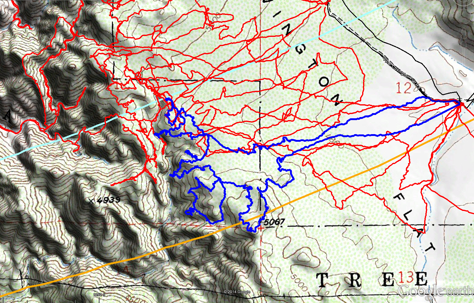
JT70 tracks are shown in dark blue. Previous search tracks are shown in red. The light blue line is the Serin Drive cell tower 10.6 mile radius and the orange line the 11.1 mile radius.
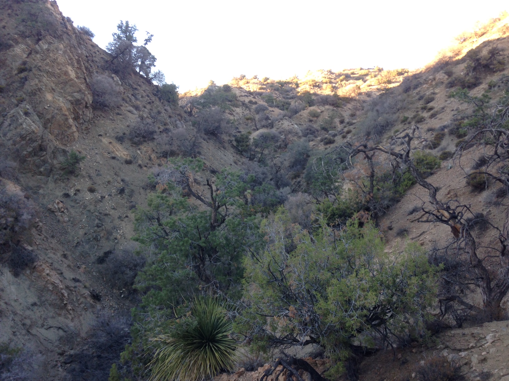
Typical terrain of the canyons coming off upper Covington Flat.
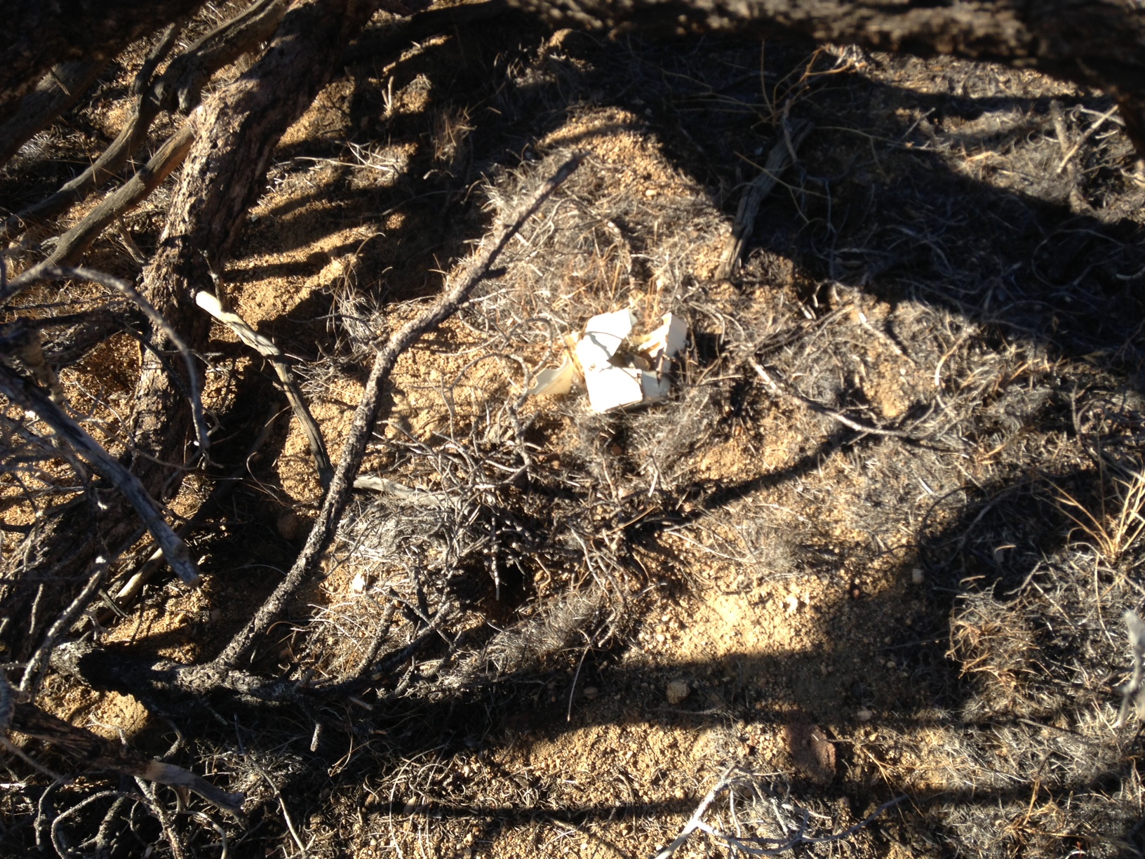
An old, half buried radiosonde. Finding radiosondes is a good indicator you’re in very lightly traveled areas.
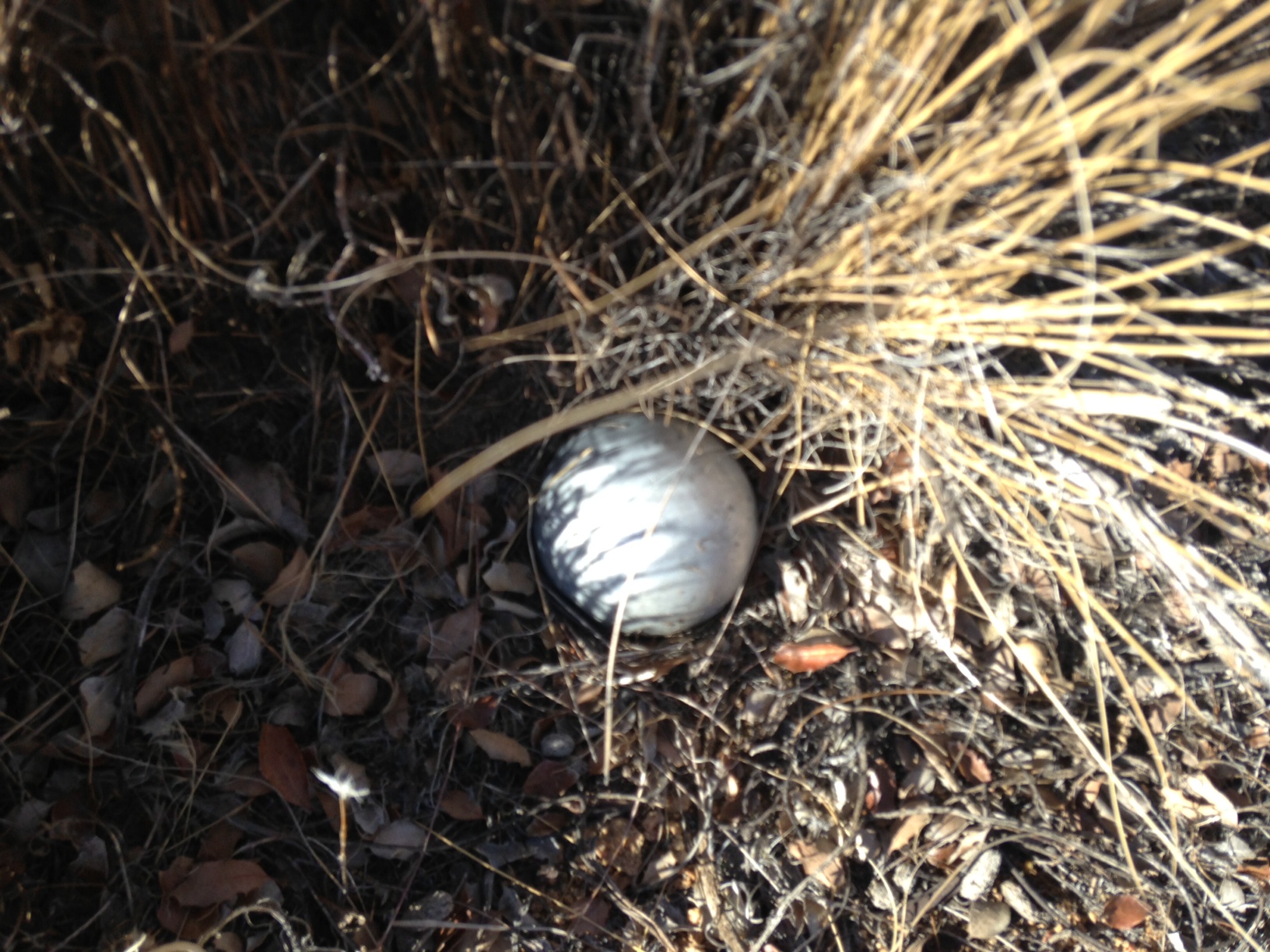
Mystery ball. This was about the size of a tennis ball, and of a silvery, plastic material. It felt hollow and had two dime sized dents in the buried portion. A half sphere, of perhaps aluminum, was found about 50 yards away.