Report and photos by Adam Marsland.
Participant: Adam Marsland
General search area: Western edge of Upper Covington Flat, Upper Covington Flat, draw separating Upper and Lower Covington Flat.
Rationale for searching this area:
Continuing to work my way into the more southerly areas of Upper Covington Flat.
Impressions of Area And Findings:
The Flat area and the ridges bounding it are relatively easy to traverse. The canyons to the west are extremely rugged and dangerous. The mountains between Lower and Upper Covington Flat are more rugged than I expected, but traversible with care.
Coverage Level:
Good on the parts of the search focused on the west edge of Upper Covington. After moving east, the search became mostly reconnaissance and coverage level declined as light fell.
Comments:
Today crystallized a lot of my recent thinking about the Ewasko mystery. Rather than waste Tom’s bandwidth with it all, I have created another webpage and done a data dump here: www.adammarsland.com/ewasko2.html.
My goal today was to continue to kick the tires of my theory that Bill might have gotten into this area and pinged the Serin Drive tower at the location first discovered in JT64, working my way further south into Upper Covington. I did not expect to find very much today, but it turned out to be one of the most interesting and productive searches to date, and after a brief misadventure I ended the day feeling I had a better sense of what exactly happened to Bill.
The questions (some of which have been ongoing) I wanted to answer today were:
1. Is there, as Verizon’s coverage map implies, actually cell coverage in the southern part of Upper Covington Flat?
2. Is there a plausible (e.g. not suicidal) entry point into the canyons that lie to the west from this area?
3. Could Bill have proceeded south from the possible JT64 ping location and then expired in this area, possibly while looking for a way out to the west (even though this would seemingly be a backtrack)?
4. Could Bill plausibly have crossed Covington Crest Trail without seeing it (necessary for him to get into this area)?
5. What are the possible entry points into Upper Covington for Bill, and how navigable are they?
Things got interesting right off the bat when, leaving Upper Covington Trailhead to start searching immediately south of where I left off in JT70, I found another radiosonde device, this time not buried but just lying on the ground. Upon arriving in the vicinity of the height of land I explored on JT70, I first checked a chute I had seen previously that had looked like it might be an easy way to get into the canyons to the west. It wasn’t. Abandoning that idea, I then followed some animal paths south along the ridgeline of the western edge of the flat.
From there, I was able to cross a saddle to an isolated height of land that jutted out to the west above the canyon areas. From here I had a good view of the surrounding terrain and all of the possible descents into the wild canyons to the west looked ugly (though some were theoretically possible if you were determined enough). More significantly, for the first and only time today, I was able to get a call out (I received a few text messages nearby as well). The call failed in the middle, so the coverage is not consistent, but this is the only area along the crest so far where there’s been actual coverage. Unlike the spot discovered further north on JT64, I do not believe this originates from Serin — this spot was in actual view of Palm Springs and extended further west towards it than the surrounding terrain, so I believe this location is the furthest reach of the cell reception from Coachella Valley.
Although the descents to the west were ugly, I was able to safely drop into a canyon between this bluff and the main land mass of Covington Flat. Here I found part of another one of those mysterious silver balls found on JT70. This one also had two dents in it but (unlike the previous examples) a hole drilled in the top.
A short way following the canyon down convinced me that this was not going to be a happy way to go, so from here I climbed up out to the western edge of Upper Covington Flat. I was also able to send and receive texts at some point in this general area, but not once I re-entered the flat. I was interested to note that although the terrain was very steep and somewhat slippery, it wasn’t a particularly dangerous or difficult ascent, just requiring a lot of huffing and puffing. Going down would have been another thing.
Once I got to the top and started resuming my search of the ridgeline, I immediately spotted something that got my heart pumping: a man-made object with nearby bones. This is what I am always searching for out here, and never find – some kind of debris field which would separate the remains of a hiker from that of, say, a wild animal.
Further investigation revealed that the bones were almost certainly animal, and that the object was a discarded can of whipped cream or cheese whiz, and that their proximity to one another was a coincidence. No connection to Bill. But given this is the first time I’ve seen anything like this, it confirms to me that if a hiker did pass away, once you got in the vicinity, it should be easy to spot.
From here I scouted around a bit trying to find a seemingly man-made object (the shape suggests a claim marker) I had marked on google Earth (as it turns out I was too far north and will take a look for it on my next outing), and poked around a bit more. Light was starting to grow dim and I really wanted to take a look at the opposite side of the flat and check out one of the two potential entry points into Upper Covington for Bill to see if it was navigable, so I started crossing the flat towards the east. From this point I was more focused on making time so I did not do as thorough a job searching, though I kept my eyes open.
One of the big flaws in the theory that Bill came to this area is he would have had to have crossed Covington Crest Trail without seeing it. I knew what to look for, so as I was traversing the flat I took video of where I crossed to see how visible it was if you didn’t know it was there and were traveling perpendicular to it. Judge for yourself:
Interestingly, along the way I also encountered the very faint remains of an old road heading south through the flat (this kind of thing is a hobby of mine). The road is easily traceable on aerial photographs, though it is almost invisible from the ground. I’m curious as to what the purpose of this road was. It seems to peter out at the south edge of the flat.
Arriving just as the sun was setting at the east edge of the flat, I started to ascend the draw that leads down into Lower Covington. The terrain got more rugged but it wasn’t too bad. My first impression was the draw area would have been a darn nice place to hang out. It had a more Alpine vibe than the flat below and some interesting rock formations that could form a shelter. I examined a few of these. Notably, the road into Upper Covington Flat was visible from here (it’s basically invisible from any point to the west, even from the highest points of land).
Once I started down the wash that eventually leads into Lower Covington, it became apparent that it would have been an intermittently pleasant, but somewhat rough, trip up from below. It could have been done, but the geography and logic dictate that if Bill did come up into Upper Covington, he would likely have entered at the south end up a canyon wash from below. I have a theory about how and why this might have happened which, again, I’ve detailed on my own webpage and won’t waste Tom’s bandwidth with. I do believe Bill could have gotten into Upper Covington through the draw I checked out today, but that it’s unlikely that he would have.
Night was beginning to fall in earnest and so I started up the rocky face of the north side of the draw, figuring based on my previous trip to this general area (JT 66) that this would be an easy scramble over the rocks and back into the flat towards my car. Big mistake. As it turns out, I was much further than my car than I thought, and instead of scrambling over one rocky low mountain, I found myself in the middle of a whole range of them, with higher and more uneven terrain to get over than I’d bargained for.
I had a somewhat harrowing half hour trying to traverse this area safely in the dusk and in that period of time caught a vivid glimpse of what Bill’s first night out was probably like. As I always do when traveling alone, I’d left my location and plans with someone on the outside along with a specific check-in time after which the rangers were to be called. The problem was, the text I was able to get out very clearly stated that I was on the west side of Upper Covington Flat. No one would then expect to find me an hour or so later wandering around in the never-visited low mountains that lie on the EAST side of the Flat. And, of course, there was no cell reception (contrary to what is shown on Verizon’s coverage map).
I’d made a dumb but understandable mistake — when you’re in an area you don’t get to visit very often, you want to push your day as long as possible and you don’t always correctly factor in your return time. As I scrambled around in the fading light it didn’t escape me that this was probably exactly the scenario Bill faced. With dusk descending (I did have a flashlight, but it wasn’t very powerful and I really wanted to keep an arm free for balance), you need to make good speed to take full advantage of what light you do have, but your ability to scout the terrain ahead of you is greatly diminished and so your likelihood of hitting ground you don’t dare traverse in the dark is increased…and of course the faster you go, and the darker it becomes, the more likely you are to hurt yourself. As long as you don’t put your foot in the wrong place, you’re OK. But the minute you are injured, a mile becomes a million miles and if you’re in a place where no one expects you to be, you’re on your own.
I was very mindful of this fact and while I moved as quickly as I dared I was still darn careful, and having a good walking stick kept me out of danger. I knew which way to head, but I had to backtrack a couple of times when the land plunged unexpectedly, which was really vexing. For that brief period I had a pretty good idea of how Bill got into trouble — and I was in a way, way better position to deal with the situation than hew would have been. The terrain was not bad enough to get me killed, and one way or another I would have been OK. If I didn’t have a walking stick, if I was 10 miles from my car instead of two, if I wasn’t somewhat familiar with the surrounding area (even if I’d been surprised by the terrain immediately around me), if I hadn’t left specific information about where to find me — bad, bad news. As it was, I wasn’t worried about my long term survival, but given my reasons for being out here, I didn’t want to become the subject of a search, even a short one, myself.
One more thing I came to understand – because I misjudged the distance I had blundered into an area that was rarely visited and wasn’t really on anyone’s radar. If you have an expectation of how things lie, and it’s inaccurate, it would be easy to get disoriented. I realized how easy it was in a low light situation to get into a spot you’d never go in the daytime, and think you were someplace you weren’t. For me, it wasn’t a huge deal. I had GPS and even without it I knew where the car was. But I could easily see how such a situation could snowball and in your desperation trying to get out before night falls and having an inaccurate sense of your own location, not only hurt yourself, but unwittingly put yourself in an area that doesn’t seem to make logical sense — where you’d be unlikely to be found and unsure of your position.
I feel like after today, I have a much better grasp of what happened to Bill. Sadly, that doesn’t help me understand where he is. I do want to continue to look further south in Upper Covington though. There’s a lot more to this area than meets the eye.
GPS Mileage for this trip: 7.0 miles.
Cumulative GPS mileage to date: 813.1 miles
GPS tracks for this trip in Google Earth kml format
GPS tracks for this trip in Garmin gdb format
GPS tracks for this trip in gpx format
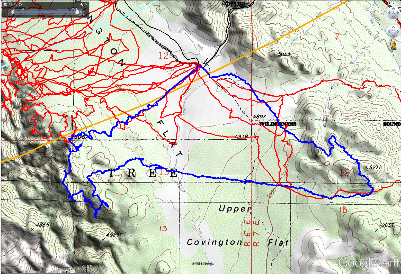
JT71 GPS tracks are shown in dark blue. Tracks from the original search are shown in black and searches since then are shown in red. The light blue line is the 10.6 mile radius from the Serin Drive cell tower and the orange line is the 11.1 mile radius.

Another weather radiosonde

Another strange silver ball with a hand to provide scale.

This is the kind of thing you’re always looking for and never see: man made objects near bones. In this case, a coincidence.
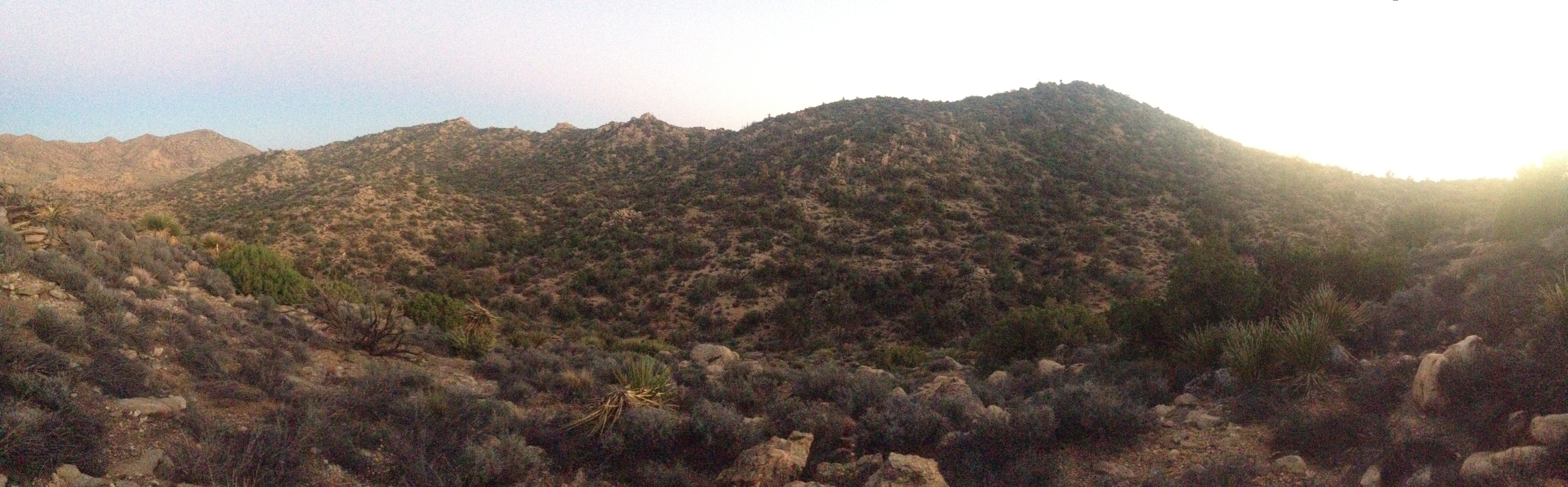
Panoramic photo of the draw between Lower and Upper Covington. Slightly rugged but navigable terrain.